FIG COMMISSION 5 TECHNICAL SEMINAR ON REFERENCE FRAMES IN PRACTICE

- REFERENCE FRAMES, DATUM UNIFICATION AND KINEMATICS

1-2 May 2016 at Rydges Latimer, Christchurch, New Zealand

The technical seminar aimed at surveyors, spatial professionals, students and operational geodesists who are interested in learning more about practical aspects of reference frames from some of the world’s leading geodesists and geodetic surveyors. As well as covering reference frame basics, the two-day seminar focused particularly on dealing with deformation and datum unification.

The Technical Seminar Reference Frame in Practice - Reference Frames, Datum Unification and Kinematics was held at the Rydges Latimer in Christchurch, New Zealand, on 1-2 May 2016 in conjunction with the 78th FIG Working Week 2016, 2-6 May 2016. The seminar was organized by IAG (International Association of Geodesy), FIG (Fédération Internationale des Géomètres), UN-GGIM-AP (UN Global Geospatial Information Management for Asia and the Pacific), ICG (International Committee on GNSS) and NZIS (New Zealand Institute of Surveyors). The seminar was attended by over 50 participants from 18 countries.

Five participants were funded by the International Committee on Global Navigation Satellite Systems (ICG) United Nations Office for Outer Space Affairs (UNOOSA).

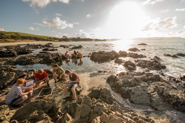
The funded participants together with Convenor Mr. Nic Donnelly, New Zealand.

Group photo

The event is supported by -


Proceedings

Sunday 1 May 2016

08:30 – 09:00 Welcome and Opening Remarks

Mr. Nic Donnelly (Convenor), Prof. Rudolf Steiger (FIG Council), Prof. Volker Schwieger (FIG Comm 5), Mr Gary Johnston (IAG), Dr. John Dawson (UN-GGIM-AP), Miss Rachelle Winefield (NZIS)

09:00 – 10:30 Session 1: Introduction to 3D Reference Frames / Datums

Prof. Chris Rizos (Australia) - presented by Mr Nic Donnelly (New Zealand)
Global reference systems and frames: ITRS / ITRF / WGS-84; transformations; determination of ITRF; contribution of geodetic techniques to ITRF: VLBI, GNSS, DORIS, SLR; the relationships between global/local reference frames and global positioning technologies.
[handouts]

10:30 – 11:00 Morning Tea

11:00 – 12:30 Session 2: Introduction to Vertical Reference Frames / Datums 

Prof. Bill Kearsley  (Australia)                                        
Gravity and geopotential numbers; physical heights (dynamic, orthometric, normal); reference surfaces (geoids and quasigeoids); levelling datums; GNSS heighting.
[handouts - 2a] [handouts - 2b]

12:30 – 13:30 Lunch

13:30 – 15:30 Session 3: Kinematic Frames and Deformation Modelling

Dr Chris Pearson (New Zealand):
Deformation Modelling 1
Kinematic vs plate-fixed frames; sources of deformation; observing deformation (CORS, GNSS campaigns); dislocation modelling; example of HTDP software for modelling in USA.
[handouts]

Dr Chris Crook (New Zealand):
Deformation Modelling 2
Role of deformation models in transforming between global and local frames; user requirements for deformation modelling; forward and reverse patches; example of New Zealand deformation model.
[handouts]

15:30 – 16:00 Afternoon Tea

16:00 – 17:30 Session 4: Case Studies 1

Mr Basara Miyahara (Japan) and Dr Koji Matsuo (Matsuo):
Case study of Japan
Semi-dynamic datum of Japan; deformation model of Japan, including the 2011 Tohoku earthquake; geoid and gravity change due to large earthquakes including the Tohoku earthquake.
[handouts]

Dr Dan Roman(United States):
Case study of USA
Current horizontal and vertical datums in USA; proposed new kinematic datum; GRAV-D project for a centimetre geoid; proposed new vertical datum.
[handouts

Mr Graeme Blick (New Zealand):
Case study of New Zealand
New Zealand Geodetic Datum 2000; airborne gravity collection and new vertical datum; requirements for a modern geodetic datum.
[handouts]

19:00 – 22:00 Seminar Dinner – Rydges Latimer

Monday 2 May 2016

09:00 – 10:30 Session 5: Case Studies 2

Brief Datum Case Studies – ICG-supported delegates
Brief presentations from ICG-supported delegates discussing current geodetic infrastructure, reference frames and plans for the future in their countries; discussion of challenges for developing nations.

Charisma Cayapan  (Philippines)
[handouts]

Joanna Kuczynska-Siehien (Poland)
[handouts]

Andrick Lal (Fiji)
[handouts]

Niraj Manandhar (Nepal)
[handouts]

Asakaia Tabuabisataki (Fiji)
[handouts]

Dr John Dawson(Australia):
Case Study of Australia
GDA94 and its relationship to ITRF (14-parameter transformation); user requirements for modernised reference frames in Australia; proposed two-frame system (plate-fixed and kinematic); deformation modelling.
[handouts]

Mr Neil Ashcroft (Singapore) – Presentation on behalf of Leica
[handouts]

Mr Paul Drummond (New Zealand) – Presentation on behalf of Trimble
[handouts]

10:30 – 11:00 Morning Tea

11:00 – 12:30 Session 6: International Geodesy Initiatives

Dr John Dawson(Australia):
APREF and UN-GGIM
Asia-Pacific Reference Frame; relationship to ITRF; benefits of connecting to APREF; contributing to APREF; role of UN-GGIM in geodesy; United Nations resolution on geodetic reference frames and infrastructure. [handouts ]

Mr Larry Hothem (United States):
Geodetic Initiatives at International Organization for Standardization (ISO)
Role of ISO; ISO/TC211 (Geomatics); Geodetic Standards; Geodetic Registry.
[handouts ]

Mr Nic Donnelly (New Zealand): SNAP Least Squares Adjustment Software
Introduction to the freely available SNAP geodetic adjustment software;reference frame transformations; utilising deformation and geoid models; coordinate calculation via least squares adjustment.
[handouts]

12:30 – 13:30 Lunch

13:30 – 15:30 Session 7: Geodetic Infrastructure and GIS

Mr Richard Stanaway (Australia):
A template for the development of a modern national reference frame
Physical infrastructure, connection to ITRF, estimating a velocity field/deformation model, vertical datums, geoid models, estimation of transformation parameters from legacy datums, local plane grids, GIS configuration using proj4 and wkt formats.
[handouts ]

Ms Ruth Neilan (New Zealand):
The International GNSS Service
Introduction to the products and activities of the International GNSS Service (IGS).
[handouts]

Dr Suelynn Choy (Australia):
Multi-GNSS
A brief introduction to Multi-GNSS.
[handouts]

15:30 – 16:00 Afternoon Tea

16:00 – 17:30 Session 8: Geodetic Software

Dr John Dawson (Australia):
SINEX Manipulation Software
SINEX manipulation for geodetic applications.
[handouts]

Mr Ryan Ruddick (Australia):
RTKLIB Software
Introduction to RTKLIB open source GNSS software.
[handouts]

Dr Chris Pearson (New Zealand):
SNAP Least Squares Adjustment Software – Nepal Case Study
Use of the SNAP software for doing calculations using a deformation model after the 2015 Nepal earthquake.

17:30 Closing Remarks – FIG Commission 5