SWEPOS® - THE SWEDISH NETWORK OF PERMANENT GPS REFERENCE STATION (Status February 2001)Gunnar HEDLING, Bo JONSSON, Christina LILJE and Mikael LILJE, SwedenKey words: AbstractSince 1st of July 1998 the Swedish network of permanent GPS reference stations, SWEPOS, is operational in IOC mode, i.e. positioning in real time with meter level accuracy and by post-processing with centimetre level accuracy. Future plans are for monitoring in real-time on the centimetre/decimetre level. Twenty-one of the SWEPOS-stations are mounted on bedrock and have redundant equipment for GNSS-observations, communications, power supply etc. Another ten stations are mostly located on the top of buildings and have less redundant equipment. The main task for these stations is real-time RTK services. All the SWEPOS stations have real time connections to the control centre in Gävle through leased lines (using the TCP/IP protocol). The purpose of SWEPOS is to:
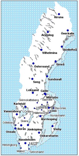
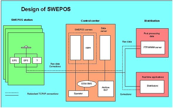
To investigate the conditions for a national service for real-time positioning on the centimetre/decimetre level, the National Land Survey, Onsala Space Observatory, the Swedish National Testing and Research Institute and Teracom (the broadcasting company for public radio and television in Sweden) have decided to form a project called NeW-RTK. The National Land Survey in collaboration with the local authorities, universities and governmental agencies also carries out pilot projects for Network-RTK in three areas. These areas are located in the most southern part of Sweden, the Stockholm area and the western part of Sweden. The tasks for these projects are to study the conditions for a service which gives an accuracy on the centimetre level with respect to the modelling of the atmospheric effects, multipath errors, predicted orbit information, reference station separation, and the distribution channels GSM and DARC on the FM-Radio network. The possibility to establish a Nordic Positioning Service is studied in a Nordic project under the responsibility of the Nordic Geodetic Commission (NKG). An agreement on exchange of data between the Nordic countries for real-time services as well as post-processing services will be signed in a near future. The SWEPOS-stations Onsala, Visby, Mårtsbo, Vilhelmina and Kiruna are included in the European network of permanent reference stations, EPN. Onsala, Borås and Kiruna are also included in the International GPS Service Network, IGS. 1. INTRODUCTIONThe development of the Swedish GPS network of permanent reference stations (SWEPOS) started in 1991 and currently 31 stations are in operation. The SWEPOS network was designed and built by the National Land Survey together with Onsala Space Observatory. During the years 1991 and 1992 the locations for twenty stations were reconnoitred and six stations became operational. The remaining 14 stations became operational in the summer 1993 which meant that SWEPOS at this time consisted of 20 stations. In 1996, the 21st station became operational. This station is located at the Swedish National Testing and Research Institute in Borås. These stations are all considered to be complete SWEPOS stations meaning that they are acting as a basis for the Swedish National Reference Frame. All equipment at these stations is doubled and they are mounted on bedrock. The average baseline length between the complete SWEPOS stations is 200 km. In connection with the development of RTK-services as well as testing of network-RTK, additional stations have been established. These are Västerås, Göteborg, Malmö, Helsingborg, Örebro, Skinnskatteberg, Hälleforsnäs, Uppsala, Nynäshamn and Stavsnäs. The distribution of the SWEPOS stations can be seen in figure 1. 2. DESIGN OF THE SWEPOS NETWORK AND DATA FLOWAll the SWEPOS stations are connected to a central node, or control centre, using TCP/IP connections. 1 Hz raw observation data and RTCM data (DGPS and RTK) are sent via the communication channels to the control centre. The control centre thus has access to all the observations in real time and provides both real time data to distributors and observation data for post-processing directly to the end user. Currently GPS measurements in Ashtech raw data format and RTCM message types 1,2,3,18,19 and 22 are transferred in real time via leased lines using the TCP/IP protocol to the control centre at the National Land Survey in Gävle. Data in RINEX format for post-processing can be fetched from the control centre through a WWW/FTP-server. Distributors of real time DGPS and RTK can receive SWEPOS real time corrections in the RTCM format from the control centre via a distribution server and a TCP/IP connection. Today the raw data and the DGPS corrections are quality checked at the control centre but so far no particular test of the RTK data is performed. Applying the DGPS corrections to raw data from an adjacent reference station and a subsequent position computation and comparison with the known co-ordinates performs the check of the DGPS corrections. The Teqc software is used for quality checking of the raw data. Some selected baselines are computed every hour as a quick check of the post-processing data. The design of the SWEPOS-network can be seen in figure 2. The development from an experimental network to IOC status has been financed by the following governmental agencies: the National Railway Administration, the National Road Administration, the Swedish Civil Aviation Administration, the National Maritime Administration, the Telecommunication Administration, the Swedish State Railways, the Swedish Defence and the National Land Survey. The development and operation of SWEPOS are both the responsibility of the National Land Survey.
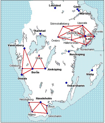
Figure 1: SWEPOS-network
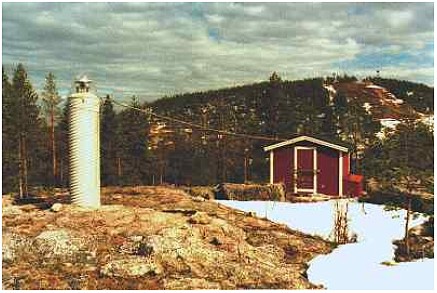
Figure 2: Design of SWEPOS 3. THE SWEPOS-STATIONS3.1 Complete SWEPOS stationMost of the original 21 SWEPOS stations were built in a similar way. A typical complete SWEPOS station can be seen in the picture below.
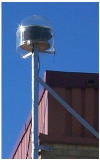
Figure 3: The SWEPOS station Överkalix
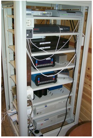
Figure 4: Inside a SWEPOS station In order to find good bedrock, an undisturbed line of sight to the GPS satellites and safe surroundings, most of the original 21 stations are situated in the countryside of Sweden. A three metre high concrete pillar can be seen on the left of figure 3. On the top, a Dorne Margolin antenna is placed under a radome made of clear acrylic. Due to the winter conditions in Sweden, the pillar is heated electrically to a constant temperature of about 15 degrees Celsius. To monitor the movements of the pillars, a small precision network is established around the pillar using steel bolts as markers in the bedrock. 3.2 Simplified SWEPOS stationIn connection with the development of RTK-services as well as testing of network-RTK, additional stations have been established. These new stations are mostly established on the top of buildings, typically belonging to local authorities. Leased lines are also used to connect these stations to the control centre. The positions of the simplified SWEPOS stations are computed in the same way and together with the complete SWEPOS stations. The position of the simplified SWEPOS stations is checked by daily computations of all stations in the SWEPOS network. Data is collected from all stations every second and a 5 degrees elevation mask is used.
Figure 5: The simplified SWEPOS station Västerås 4. THE INTERACTION BETWEEN SWEPOS AND GLOBAL/EUROPEAN REFERENCE SYSTEMS (OFFICIAL EUREF AND IGS SITES)The National Land Survey and Onsala Space Observatory has been active in international projects. The European countries have collaborated in building up a network of permanent GPS stations as well as computing national realisations of the adopted European three dimensional reference system ETRS 89. This work is done under the IAG Subcommission for Europe (EUREF). EUREF is also engaged with the establishment of a common vertical reference system based on the national levelling networks and the European GPS campaign EUVN. The realisation of ETRS 89 in Sweden is called SWEREF 99 and replaces SWEREF 93. SWEREF 99 was (certified) accepted by EUREF in June 2000 and is defined by the 21 complete SWEPOS stations. The SWEPOS stations Visby, Onsala, Martsbo, Vilhelmina and Kiruna are included in the European network of permanent reference stations, EPN. Data is delivered every hour to the data centre at BKG (Federal Agency for Cartography and Geodesy) in Germany. Data in the EPN network is processed at a number of analysis centres in Europe and the results from these computations are combined to one solution per week, which is available on the EUREF web-site. The data from the Nordic block of EUREF sites is processed at the Nordic Commission of Geodesy (NKG) processing centre at Onsala Space Observatory. Onsala, Borås and Kiruna are also included in the network for the International GPS Service (IGS). 5. SWEPOS SERVICESData from the SWEPOS network is available for the end user via the following services
5.1 Data for post-processingSWEPOS data is available on a WWW/FTP server in RINEX-format. The following data files are available:
Quality checked data is available on the WWW/FTP server for download within one hour after the observation on the SWEPOS station. Data is charged according to a subscription system, see below.
5.2 Automatic Computation Service on the SWEPOS WebThe National Land Survey has developed an automated processing service in order to facilitate the use of SWEPOS for accurate static post-processed point positioning. The Bernese GPS software and a webpage/email is used for the computations. The position for any site in Sweden can be computed by submitting an observation file containing dual frequency data in RINEX format to the Automatic Computation Service via the SWEPOS Web-site. The observation file must also contain approximate co-ordinates for the observed site, antenna height and information about the type of antenna. The computation service will compute a position for the observation site based on the five closest SWEPOS stations, models for the SWEPOS- and user antennas and precise ephemerides. When the processing is completed (typically after 5-10 minutes) the Webb page is updated and a text file with a summary of the processing is sent to the user by e-mail. The final co-ordinates are delivered in the national reference system SWEREF 93 (soon changed to SWEREF 99), a realisation of the European reference system ETRS 89. The users have to transform the results to the desired local reference system if this is required. The following position accuracy can be expected:
5.3 The DGPS-service Epos, operated by TeracomEpos is a DGPS service operated by the Swedish state company Teracom. Teracom, which also is the Swedish broadcasting company for public radio/TV, broadcasts the corrections via the FM network on the RDS channel of the public channels three and four. An accuracy of 1-2 metre is achievable over most land and sea areas of Sweden. 5.4 The DGPS-service Mobipos, operated by Generic MobileMobipos is a single station DGPS service operated by the Swedish company Generic Mobile. Generic Mobile broadcast the corrections via the FM network at the DARC (Data Radio Channel) channel at the public channel three. An accuracy of 1-2 metre is achievable over most land and sea areas of Sweden. 5.5 The network WADGPS-service, operated by FugroOmniSTAR is an international Wide Area DGPS service operated by the multi-national company Fugro. OmniSTAR is a world wide service using geostationary satellites for the distribution of the corrections. The elevation to the geostationary satellites is low at high latitudes, which reduce the availability especially for land applications in northern parts of Sweden. An accuracy of 1-2.5 metres is achievable over most land areas world wide. 5.6 The RTK-service Ciceron, operated by TeracomCurrently single station RTK data is broadcast from eight SWEPOS stations. No modelling of the error sources is performed. It is therefore only possible to use the RTK service up to approximately 20 km from each station. The RTK data is distributed on the DARC channel on the FM-radio network at the public channel four. 6. ON-GOING DEVELOPMENT PROJECTSIn order to attain an efficient real time positioning service which gives a position accuracy on the centimetre level it is necessary to combine data from a number of stations in a network solution, see figure 6.
Figure 6: Coverage with single station RTK and network RTK For RTK the coverage of a reference station is a circle with the radius 10-20 km depending on the influence of activities in the atmosphere. By using Network-RTK the distances between the reference stations and so the coverage area can be increased. In order to develop a Network-RTK service for parts of Sweden, development projects are going on in co-operation with local authorities, governmental agencies, universities and Teracom. The SWEPOS facilities are used for data collection and data distribution. There are also plans to exchange data from all the Nordic stations for real time as well as post-processing services. The development projects are described below. 6.1 Project NeW-RTKNeW-RTK is a collaboration project between the National Land Survey of Sweden (NLS), Onsala Space Observatory, the Swedish National Testing and Research Institute and Teracom. The project was scheduled to end 1st of February 2001 and the main task of the project was to test different systems for network RTK in SWEPOS and to use the DARC channel on the FM-radio network as distribution channel. The final task is to find out the possibilities for the establishment of a nation wide RTK service, providing an accuracy on the centimetre/decimetre level. For test purposes a platform has been is established in the south west of Sweden. The nominal baseline length in SWEPOS is about 200 kilometres. However, the network in this area is denser with several baselines shorter than 70 kilometres. The test area currently consists of six stations; Vänersborg, Jönköping, Göteborg, Onsala, Borås and Skara. In the test area RTCM data is broadcast via DARC. The data rate with DARC is between 4 and 9 kbps depending on coding of the data and demand of real time parameters. During the tests the FM station in Borås is transmitting the network RTK data. It is also possible to broadcast the data via GSM. So far Network-RTK softwares from Geo++, Terrasat, Onsala Space Observatory and Roberton Enterprices Ltd are installed at the SWEPOS control centre. Since all the softwares are in more or less advanced development stages it is not possible to present any detailed information about our experiences so far. 6.2 The projects SKAN-RTK and Position Stockholm-MälarenThe purpose of these projects is to obtain experiences of the operation and performance using currently available Network-RTK systems. In these two projects the partners are a number of local authorities, Onsala Space Observatory, University of Lund, National Road Administration, National Rail Administration, National Land Survey and the SWEPOS co-operation group. The set up of these projects is that real-time data is collected from a number of SWEPOS stations and some temporary reference stations to the SWEPOS control centre and entered into the Network-RTK software GPS Network from Terrasat. Since there is no standard format for Network-RTK data the GSM cellular phone is used as distribution channel. The user dials the SWEPOS control centre, where the GPS network software is installed, and the approximate position is transferred from the GPS receiver. The GPS Network computes a corrected RTK data set and sends it via the GSM channel back to the user. In the first part of the SKAN-RTK project a lot of work was required for the connection of some brands of GPS receivers to the GSM modem. The use of satellite almanacs and predicted ephemeris in the GPS Network software also required some extra attention. The surveying teams in the field have had both good and not so good experiences. But all the surveyors, who are involved in these projects, are convinced that the Network-RTK concept is a very efficient concept for surveying of details. More detailed results from the project will be published later this year.
Figure 7: The three test platsforms for network-RTK existing at present in Sweden. From top to bottom are the areas for the projects Position Stockholm-Mälaren, New-RTK and SKAN-RTK. 6.3 Nordic Positioning ServiceThe Directors of the Nordic Mapping Authorities have agreed to exchange data for post-processing as well as real-time services from the Nordic networks of permanent reference stations free of charge. The end-user or distributor is charged according to the fees in each individual country. If funds are available the long-term goal is to establish
At present there are funds allocated for transfer of know-how between the Nordic Mapping Authorities and free exchange of software developed at respective Mapping Authorities. 7. CONCLUSIONSince 1st of July 1998 the Swedish network of permanent reference stations, SWEPOS, is operational in IOC mode, i. e. positioning in real time with position accuracy on the meter level and by post-processing on the centimetre level. Future plans are aiming at positioning in real-time on the centimetre/decimetre level. Collaboration in the area of Network-RTK between local authorities, governmental agencies, state companies and universities development projects are going on in three geographical areas in Sweden. An important question is whether a standardised Network-RTK message for broadcasting can be developed. Future plans are real time positioning services which gives positioning accuracy on the centimetre/decimetre level in selected parts of Sweden. These services will be established by SWEPOS in collaboration with local authorities. REFERENCESEurenius B, Jivall L (1998): The Use of SWEPOS and GPS in Local Control Networks, Presented at the XXI FIG Congress, Brighton, 1998, Commission 5, 318-330 Jivall L, Lidberg M (2000): SWEREF 99 - an Updated EUREF Realisation for Sweden (2000), Report on the Symposium of the IAG Subcommission for Europe (EUREF) held in Tromsö, 2000. Jivall L et. al. (2000): SWEPOS Automated Processing Service, Report on the Symposium of the IAG Subcommission for Europe (EUREF) held in Tromsö, 2000. Ottoson C, Jonsson B (1998): GPS Positioning with cm-level Accuracy in Real Time, Proceedings of the XXI FIG Congress, Brighton, 1998, Commission 5, 43-56. Vollath U et.al (2000): Multi-Base RTK Positioning Using Virtual Reference Stations, Proceedings of the International Technical Meeting, ION GPS-2000, Salt Lake City, Utah, 123-131. Wübbena G, Bagge A, Seeber G, Böder V, Hankemeier P (1996). Reducing Distance Dependent Errors for Real-Time Precise DGPS Applications by Establishing Reference Station Networks. Proceedings of the International Technical Meeting, ION GPS-96, Kansas City, Missouri, 1845-1852. Web sites:
BIOGRAPHICAL NOTEMr. Gunnar Hedling is a Senior Research Geodesist at the Geodetic Research Division of the National Land Survey of Sweden. He received a M Sc. in applied physics from Lund University in 1986. He has worked with different GPS applications during the last 15 years. Mr Bo Jonsson is graduated with a B. Sc. in mathematics, physics and astronomy from University of Lund in 1969. Courses in Geodesy at the University of Uppsala in 1974. He is working as GPS Program Manager and Deputy Head of the Geodetic Research Division of National Land survey since 1996. Mr Jonsson is secretary in the Presidium of the Nordic Geodetic Commission. Mrs. Christina Lilje graduated as a land surveyor from The Royal Institute of Technology, Stockholm, Sweden in 1993 with main subjects concerning Geodesy, Photogrammetry and GIS. She has worked at the National Land Survey since 1993, except 1998-1999 when she was working with technical support at Ashtech Europe. She is working as a research geodesist at the Geodetic Research Division with GPS and particularly RTK and network RTK. Mr. Mikael Lilje graduated as a land surveyor from The Royal Institute of Technology, Stockholm, Sweden in 1993 with main subjects concerning Geodesy and Photogrammetry and GIS. He has worked at the National Land Survey since 1994. He is working as a research geodesist at the Geodetic Research Division and mainly with the ongoing third precise levelling of Sweden. Mr. Lilje is the secretary for FIG Commission 5. CONTACTGeodetic Research Division 17 April 2001 This page is maintained by the FIG Office. Last revised on 15-03-16. |