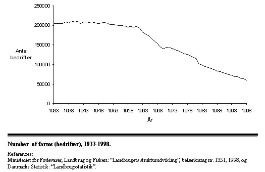
RESTRICTIONS IN LAND USE - INFORMATION AND CONTROLBodil EKNER, DenmarkKey words: Restrictions; Habitats; Regulations; Control; Information. AbstractThe rural area is not only a resource for agriculture. In many countries it is also from this area the population gets the Drinking - water. The environment, the nature, the biological diversity and the cultural heritage must be protected. All the different demands for use of the rural areas do not always consist with each other and the problem is how to at the same time both use and protect the rural areas. In Denmark we work with these problems both in the regional planning and in our legislation but these tools are not good enough. It is a very important task to ensure that the landowners know about the regulations and know the consequences for the current and the future use of his/her land. Unfortunately knowing about the conditions for using land is not enough. The landowners must also act in accordance with the conditions. In Denmark we therefore have a control-program with control in the fields or via air-photos and with obligatory reports from the landowners on use of fertilizer and manure and the crops of each parcel of land. INTRODUCTIONThis paper will mainly deal with regulations in the rural areas of Denmark. The rural area in Denmark covers totally 2.691.000 Hectares (1996, The Danish Statistic) The rural area is not only a resource for the Agriculture. In Denmark as in many other countries it is also from this area the population of the country gets the Drinking - water. The environment, the nature, the biological diversity and the cultural heritage of the country must be protected. As many of the 14 Danish counties are poorly wooded, we also have a "Re-forestation program". The rural areas are also for recreational use to the growing population of the cities. There are many wishes to the use of the rural areas. So many that we often conclude the area should be much bigger or the use strictly regulated if all the wishes should be fulfilled at the same time. It is not easy both to use and protect the rural land at the same time. The rural areas are in focus especially due to the environmental problems from the agricultural use of the areas. This use influences conditions of living for animals, plants and human beings. The intensification in production, the development of new ways of production and the bigger and bigger farms (economies of size) have -especially the last 30-40 years- caused a homogeneous landscape, an extensive loss of natural and semi-natural habitats and of many plant- and animal species. This development has also caused that we to day only have a few people living on each farm. The development in number of farms in Denmark
Denmark is an intensively cultivated country of which today farmland covers 61.5 percent (56,4 percent is in agricultural rotation) forest and plantations 12 percent and natural and semi-natural habitats as lakes, meadows, heath and dunes 12 percent. Small habitats as hedges, dikes, field boundaries, edge of ditches and stone fences covers only 2.8 percent and semi-natural habitats only 5.5 percent of the farmland in Denmark. Although we to day have a lot of restrictions in land use we know that the future will bring us much more and also that bigger and bigger farms, and this will have an appreciable influence on our landscape and our agricultural production. TO DAYS REGULATIONS OF THE USE OF THE RURAL AREASIn the report "Agriculture and Spatial Planning" the regulations of the rural area is described as three different types of regulations:
GENERAL REGULATIONS IN LAWGeneral regulations are such regulations as e.g. include all farms, or all constructions (maybe only in a city or in the rural area) or all woods. The Planning Act The Planning Act regulates all uses of the Danish area. The Act has the aim to secure that the planning in Denmark unites all interest of the society and contributes the protection of nature and the environment so that the development of the Danish society can take place in a sustainable way. The Planning Act divides Denmark into three zones: the Urban Zone, the Rural Zone and the Zone for Holiday Cottages. In the Rural Zone usually (not the very big) constructions for Agriculture, Forestry and Fisheries can be build without special permissions, except constructions for animal production which may harm Environmentally Sensitive Areas (EAS) or areas of Special Scientific Interest (SSSI) or may cause nitrate seepage to the Ground Water. If an implementation of a project (constructions or a buildings) may cause damage on sensitive areas, SSSI-areas or ground Water, the project must go through a planning process "an Environmentally Feasibility Study" (VVM). The project can only be implemented if the VVM has given the result that the project or maybe the project with some changes would not make any harm to the environment. The Protection of Environment Act The objectives of the act are mainly to prevent and combat pollution of the air, the land and the underground. The Act prescribes that those who runs factories or farms and the like which may pollute have to make different deprecating installations which can ward off the risk. To protect neighbours to animal-farms against noise and odour from the farm the act contains some conditions for the distance between a stable/container for manure and e.g. a dwelling, a village and a city. Big animal farms shall have a special approval (IPPC) with conditions for running the farm. To protect land and groundwater has been laid down in the act that a dairy-farm must have (owned or rented) at least 1 hectare for each 2.1 equivalent animal1 on the farm (for spreading the manure) and pig farm at least 1 hectare for each 1.7 equivalent animal. In the year 2002 the farmers will need more land. To secure that the manure only is spread when the vegetation need manure each animal farm must have containers big enough to keep all the manure from the farm for 9 month. 1) 1 dairy-cow is 1,18 equivalent animal, and 3 sows or 30 slaughter-pigs are 1 equivalent animal The Agricultural Holdings Act This Act regulates the use of farms and who is allowed to buy a farm. The act has many conditions to be fulfilled by those who acquire a farm. E.g. the acquirer must be at least 18 years old and a citizen of EU. He/she must take permanent residence on the farm, have an agricultural education and manage the farm himself/herself if the farm is bigger than 30 hectares. If the farm consists of more than one holding (1 person and his/her nearest family can only together be the owner of 3 holdings) the road distance from the dwelling in which the farmer lives to the other holdings must not exceed 10 kilometres. The Act also regulates how big a holding must be by amalgamation (125 hectares) how big an area each farmer must manage (375 hectares) and how many animals he/she can have on each holding (depending on the size of the holding) and on his/her farm (750 equivalent animals). The Act does not regulate which crops the farmer can cultivate. Agricultural use of Fertilizer and Manure and the Cover of Vegetation Act To minimize the leaching of nitrate from the soil and optimize the benifits of fertilizer and manure the use is regulated (the amount of nitrate the farmer must use depends on what sort of crops he/she grows and in which region his/her fields are situated). And besides other regulations it is also laid down that 65 percent of his/her farmland shall be covered with green plants at wintertime. Every year in September and Mars the farmer must make a plan showing which crops he will grow in the different fields of the farm (starting in September and ending in March), the use of fertilizer or manure and which fields he/she will set aside. The year after in Mars he/she shall fill out a fertilizer and manure return and send it to The Plant Directorate for control. Protection of Nature Act The objectives of this Act are mainly
The most important of the regulations in the Act are Area - Based Regulations (see later) but also a great number of general regulations in the Act matters. According to the Act beaches and other stretches of coast shall be open for passage on foot, occupancy for a short period of time and bathing if there is no residential buildings within a distance of 50 meters. Public owned forests shall be open for passage on foot and bicycle and for occupancy if there is a legal means of access thereto. In privately owned forests, passage on foot shall only be permitted on paths and established roads and bicycle passage only on paths with a consolidated surface and established roads and only from 7 a.m. until sunset and it is prohibited to stay within 150 metres from residential and operations buildings. Uncultivated areas shall be open for passage on foot and for occupancy (not near to residential buildings) if there is a lawful means to access thereto (for private areas only between 7 a.m. and sunset). Established roads and paths in the countryside shall be open for foot and bicycle passage. Restoration and creating areas for animals, plants and landscape take place on areas acquired by the National and Forest Agency. The Agency has a right to use compulsory purchase if it's impossible to buy. Safeguarding of Watercourses Watercourses and their adjacent areas is regulated in several laws and departmental orders so as the Watercourse Act, the Water Supply Act, the Protection of Environment Act, the Protection of Nature Act and the Ochre Act. Together these regulations shall e.g. ensure that water from the fields can drain off, that the quality of the watercourses and the lakes (the Water Environment) come up to the aims in the Regional Planning (see later), and that the farmers can get water for watering the crops. Besides the mentioned acts we have other with only a few regulations. Among these I will mention the conditions for getting the Hectare subsides. To get the hectare subsides the farmer must make a declaration of the size of his/her fields what sort of crops there are on each field and the size of the set aside area. Mistakes or dishonest in the declaration so as wrong size of a field means loos of subsides. In Denmark the farmers can also loose some of the subsides if he/she has used to much fertiliser (which can be seen in the fertilizer-return) or does not keep the 2 meter protected zone along watercourses and lakes (Cross Compliance) REGULATIONS GIVEN BY SPATIAL PLANNINGIn the rural areas it is mostly the regional planning which has an interest. The County and the Municipal Councils must follow the planning. The landowners are not obligated to follow the planning. However on areas on which "forestation is unwanted" (where it is not allowed to plant wood), areas for creating new Wetlands (where it is not allowed to build) and areas for protecting Drinking- Water (where we soon will get some still unknown restriction in land use) the planning is binding. In the regional planning you will find which uses the County Councils prefer and wishes on the different areas of the county. When a landowner or others want to get a permission to e.g. build a house or a factory, he or she will not get the permission if the wanted use do not fit into the regional plan. The regional plans shall have guidelines for
These guidelines are in force when anyone ask for a permission to e.g. build a house, a big stable, make an industrial construction, make use of raw materials and the like. AREA - BASED REGULATIONS LAID DOWN BY LAW OR ASSIGNED FOR SPECIAL PROTECTIONSArea based regulations are mostly decided to protect habitats, landscapes with special qualities, Environmentally Sensitive Areas and areas where it's necessary to protect drinking water. Habitats protected by Law After the Protection of Nature Act it is prohibited to alter the state of natural lakes of more than 100 square-meters and of watercourses or parts of watercourses that have been designated as protected watercourses. The prohibition does not apply, however to any normal maintenance of the activity in the watercourse. It is also prohibited to alter the state of heats, bogs, marshes, moors and the like, salt marches, swamps and coastal meadows, humid permanent grasslands and uncultivated, dry meadows, when such habitat types total more than 2.500 square-meters either separately, jointly and in connection with a protected lake or watercourse. The prohibition is against e.g. to drain, to cultivate. Use of fertilizer is also prohibited unless the area has been fertilized before the protection was decided. If so you can use fertilizer as it was used before the decision. The protected habitats is registered on maps but as the Nature is changing so an area that to day is a meadow (without grassing) to morrow will be an area with shrub are the maps only attended as a guide. If there are any differences between the map and the reality it is the reality which counts. The maps are only made as a tool for the administration. It is also prohibited to alter the state of walls of stone, earth and the like and to alter the state of ancient monuments. Parcelling out, land registration and transfer of ownership of land whereby new boundaries are established through ancient monuments is also prohibited and so are soil treatment, the application of fertilizer and planting on the monuments and within 2 meters from them. After the regulations in the Watercourses Act it is prohibited to cultivate the field and so is soil treatment, planting, regulating of the conditions of the ground, fencing and building within 2 meters from some of the watercourses and lakes. Protecting Lines Within 100 metres2) of the beginning of continuous land vegetation is it prohibited to alter the state of beaches and other stretches of coast. It is also prohibited to erect fences and to place caravans and the like on such areas. And as for old monuments also here parcelling out, land registration and transfer of ownership of land whereby new boundaries will be established, is prohibited. It is prohibited to place buildings, caravans and the like within 150 metres from lakes (with a surface area of at least 3 hectares) and from some watercourses and within 300 metres from forests. In the protected area along lakes and watercourses it is also prohibited to plant or alter the surface of the ground. Within 100 metres from ancient monuments it is prohibited to change the state of the area, to erect fences and to place caravans and the like. It is also prohibited to erect buildings more than 8.5 metres tall within 300 metres from a church, unless the church is surrounded by urban settlement in the entire protection zone. 2) 300 metres at some coasts Nature Conservation The Nature Conservation Board may adopt conservation orders on land areas and bodies of fresh waters mainly with compensation to the landowner. Such areas covers today about 4 percent of the rural areas. For each area is decided what shall be protected and what is allowed to the owner and what isn't. Also the dune areas is under conservation. It is prohibited to alter the state of dune conservation areas, Such areas shall not be fenced and grassing is not allowed. It is also prohibited to place caravans and the like in such areas. Parcelling out, land registration and transfer of ownership of land whereby new boundaries are established are prohibited. International appointed safeguarding In Denmark we have acceded to the Ramsar-convention and have selected 27 areas (both on water and land) as Ramsar-protected. We have also implemented the EF Bird Directive and the EF Habitat Directive. All these areas are shown on the maps of the Regional Planning and the reason for selection of the areas is described for administration of the necessary regulations. We have also established areas for the wild animals free of hunting and other disturbances but no National Parks. Protecting of Drinking Water Areas under which drinking water for to day and for the future will be formed is marked on the maps of the Regional planning and on the next generation of plans it will appear which of these areas it will be necessary to protect specially and from what (nitrate, pesticides). After the publication of the Regional plans the extent of protection shall be decided and also which instruments we shall use. Areas where it's possible to get subsidies The common policy in EU is using subsidies to get an influence on the development. Taking about the rural areas and Area-based regulations the most important is subsidies for forestation and subsidies for environmentally friendly agriculture in Environmentally Sensitive Areas (EAS), and among these the subsidies for 20-years set aside. Round areas where we have created new wetlands it is necessary for getting the optimum of nitrate-removal that the farmers enter into a contract on environmentally friendly agriculture. To ensure that we get the best possible result we use land consolidation. In that way those farmers who have a need for land on grounds of the size of their livestock get normal areas while farmers with other interests can get the EAS-areas with possibility to get subsidies. Information and ControlAlthough we have a lot of regulations in the rural area it is still possible to do something on your land without a permission e.g. to cultivate the land (maybe only in a special way) and build small production buildings for agriculture, forestry and fishing not houses for living (normally). If someone had build a house (or other construction) without the necessary permissions from the Municipality-Council or the County-Council he/she can be forced to take it away again if it is not possible to get a following permission. Is it easy to control that people do not make constructions without permissions? Because of the small size of the country and the many roads it is normally easy to se what has been build but we also now and then take an air-photo and compares it with earlier photos and the given permissions. Control of the fulfilling of the conditions for hectare-subsidies is to day done mainly by comparing of the size of the fields given by the landowners in his/her application with the size on maps made of air-photos. Every year some of the receivers of hectare-subsidies are controlled by measuring their fields and controlling their crops and set aside. At the same time we also can control their livestock and their use of manure and fertilizer. The information about the livestock, the fields and much more is feed into a computer so that the information can be used of the local authorities and also the local commissions for agricultural development which administrate the Agricultural Holdings Act. Of course it is necessary that the authorities can control the landowners but it is in many ways more necessary that the landowners know what restrictions there are on their land. Until a few years ago it was only the authorities that knew anything of this. A landowner could of course go to the county administration and get the information but only a few did. After a long period of discussions it was about 3½ years ago decided that the County administration within two years should inform every landowner in the rural area of the position of all protected area on his/her land and which consequences these regulations had. The information should be given by sending a letter to the landowners. But before the end of the two years the decision was changed. In the meantime so many had got the possibilities to get to the Internet that the information instead of being send by post was laid on the homepages of the 14 Counties. To day no landowner can excuse his mistakes with ignorance of the position and consequences of the protected areas on his/her land. CONCLUDING REMARKSAll this regulations will in my opinion not be enough in the future. The farmers who is the section of the Danish population which owns the biggest part of the rural area have need for more land to spread the manure from the intensive animal-farms especially when the conditions for spreading the manure is tightened in 2002. At the same time some of the other part of the population declare that the farmers can not control the rural areas as these areas belongs to the society so that those who not owns any land also shall have some users rights. The model is maybe the Swedish "all men's right" but it is not easy to have such rights in an intensively used landscape. To try to make some solution we have formed some Task Forces and committees which each of them will give our "Folketing" (Parliament) some ideas of how to regulate the rural area of Denmark in the future. REFERENCESAgriculture and Planning (Landbruget i Planlægningen) The
Directorate for Agriculture and Fisheries, 1996 Minutes from the 4th meeting in the Wilhelm Committee, 2001 National Strategy for a Sustainable Development, Agriculture, Fisheries and safety of Foods, Ministry of Food, Agriculture and Fisheries as on part of a coming governmental report, 2001 Papers to the 5th meeting in the Wilhelm Commitee , 2001 Papers from the Task Force on information of landowners, 1997-1998 Several Danish Acts. BIOGRAPHICAL NOTEBodil Ekner, born 1941 in Varde, Denmark CONTACTBodil Ekner 18 April 2001 This page is maintained by the FIG Office. Last revised on 15-03-16. |