REFORM OF LAND CADASTRE IN LITHUANIARomualdas KASPERAVICIUS, LithuaniaKey words: AbstractMain aim for every Government is to create legal, financial and organisational circumstances for real property. To search new ways that persons entitled to restitution of ownership in land and who are not able to work it, the right of ownership transfer to the others or sell to those who have possibilities to work it. It is very important to pass laws and to improve the existing ones which must determine how land market should function and to create circumstances for more effective operation of the land market. Laws, regulating the restitution of citizens' ownership in land and legislation on land reform, should be stable. Very important to reform existing and create a unified real property cadastre and registration system. Management of cadastre activity and registration of land and buildings (apartments) should be made in one organisation but not in different ones. The creation of effective and secure real property administration system is an essential thing for the successful market functioning and welfare of the country's economy. 1. INTRODUCTIONAfter the reestablishment of independence of Lithuania, significant changes took place in a short time. Very important laws on restoration of ownership rights in real property, laws on land and other real property registration, on taxation and other laws and sub-legal acts were passed. Existing laws, providing for the integration of land and other real property cadastres and registers, is a basis for the security of restituted ownership rights in creating confidence between private owners, farmers, business men and banks. There are greater possibilities that banks will provide credits under reasonable interest rate and business men will invest more money to the economy of the country and agriculture. The existing institutional structure for the management of land and other real property is not convenient for users and it does not meet the interests of the public and the state in developing land and property market in Lithuania and integrating Lithuanian agriculture and economy into the European Union. Main strategic objectives for the reforming of existing cadastre system are the following:
2. ORGANISATIONS RESPONSIBLE FOR REAL PROPERTY ADMINISTRATION SYSTEMThe structure for land reform, real property privatisation, land survey works, land and other real property cadastre, national mapping split among separate ministries and organisations:
State Land Cadastre and Register (SLCR) is a most important organisation in reforming existing and establishing new Real Property Administration System. SLCR is a governmental organisation which methodically guide Real Property Cadastre and Register. It also provides services of surveying, technical support and training for it's Branch Offices while carrying out Land cadastre, registering ownership rights to restituted land (forest), privatising land, buildings, apartments and engineering equipment. Very important part of SLCR - Central Real Property Databank. It's main task to storage Real property data, to provide information service to clients, technical support and training to Real Property Cadastre and registration system. Legal situation on payment for search of information and registration is solved by Government. 3. CADASTRAL SURVEYINGWhile performing the restitution of ownership rights to land (forest), land privatisation and selling, it is necessary to determine the size and location of a land parcel. Land parcel boundaries are fixed very quickly and economically in a graphic way on a map by using the best available maps. Usually land use maps of former collective or state farm, made on the basis of 1:10,000 topographic map, are used for rural areas. From 1993 smaller farming land areas (2-3 ha) were started to be drafted into maps in scale 1:5000. Precise geodetic surveys are usually made in cities and settlements. Land in urban areas is far more expansive than in rural areas or maybe citizens inherited the traditions that a privatised or bought parcel should be surveyed precisely with geodetic instruments. Though, according to the existing laws land privatisation can be done in cities and settlements without geodetic precise surveying with geodetic instruments. The location of a household - land parcels can be plotted graphically by using the best large scale map. Maps in scale 1:1000 or 1:2000 are used in urban areas but some city centres have maps in scale 1:500. According to the existing Governmental decision new land owners should pay for the precise land parcel surveying themselves before registering sold land in Land Register. All procedures of property formation are described in a Land Cadastre Law, what was adopted by parliament in 2000. Mean fee for the precise survey is about 200 Lt (50 $) for one parcel in urban area and about 100 Lt (25$) for one hectare of farming land in rural area. 4. LAND CADASTRE MAPSRegional GIS groups were established in 1998 in the SLCR. The main purpose of these groups is to compile a consolidated land cadastre parcel map on GIS data base background and digitised administrative boundaries of land parcels in cadastral areas and these boundaries are drawn graphically after preliminary or precise survey. Now 42 Lithuanian districts or 98% of the whole territory of Lithuania are digitised. Lithuania is divided into cadastral units and there are 1396 of them. Boundaries of cadastral units usually coincide with natural features and administrative boundaries. A map in scale 1:10,000 will be produced for each cadastral unit. In addition a map in scale 1:5000 is being produced for settlements. Land cadastre units maps are compiled on the basis of new topographic map and cadastral information is put on these maps. Parcels GIS data base, actually, is the second part of Land Register where graphical data about each parcel is registered. Each parcel after geodetic surveying must be co-ordinated with GIS group before it is submitted for legal registration. There is a need to have a sufficient financing in order to have proper large scale maps for urban areas and information necessary for services provision, land use and city development. Each cadastral unit is divided into blocks. A number which unique
in the block is given to each land parcel.
Boundaries of cadastral units in municipal boundaries coincide with administrative boundaries. If administrative boundaries change the boundaries of cadastral units and blocks will be changed correspondingly and will be co-ordinated with the boundaries of formed properties (parcels). 5. REGISTRATION OF LAND AND OTHER REAL PROPERTYWhen private ownership was introduced there was a need to secure rights to land and other real property and cadastral surveying started to be made and cadastral maps were used which were prepared by using the best available maps in scale 1:10,000 and larger scale maps. The main task is the creation of unified register for rights in land and other real property. That is why both owners and bankers trust more real property registration system and the investments can be stimulated. Primary registration of land and other real property made a great progress in Lithuania but for the full integration of land and buildings registers there will be a need of additional human and technical resources, efforts and diplomacy. In order to support Real Property registration and management there is a system created which operates in 11 CLCR Branch Offices and 37 Districts Client Service Bureau. 5.1 Local Land RegisterLocal Land Register is on PC-based system for land ownership registration handled by the 47 CLCR Branch Offices and 37 Districts Client Service Bureau. Every hour a new records in the local databases is sending to the central system at the State Land Cadastre ad Register for analysis, checks of data and etc. The legal register consists main data about owner, characteristics of land parcels, restrictions on land use, easements, servitude's, buildings, pledging and mortgage. From the System different kind of print-outs can be made such as land parcel register certificates, certificate of transactions. 5.2 Central Real Property Register DatabankThe core of Real Property Register is being developed at the State Land Cadastre and Register. There are also some possibilities for communication to the central system. Central system is connected to the Statenet (a TCP/IP based communication network) and through this network CLCR Branch Offices and Districts Client Service Bureau can access the central system, and through this network Internet can be accessed. Statenet is also used by agencies such as Economic Police, State Security, General Prosecutors office if they need to access the central system. SLCR have built a user interface to the central system by using Internet techniques. In order to access the information via this solution user have to have identity and a password. 5.3 Integration of Land Register with Other RegistersThe integration element is property unit identifier - for parcel and building. Through this identifier connection with GIS database is ensured. Other integration element (cross-reference) is parcel and building central co-ordinates. For the effective functioning of Real Property Administration System and benefit to the public the following issues should be solved:
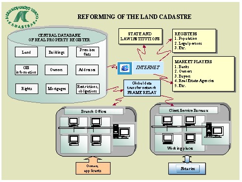
5.4 Real Property RegistrationRegistration of ownership have recently been running at some 9,000 - 10,000 per month, a 10% improvement on the average one month earlier, and there are now approximately more than 900,000 entries about parcels and 3.1 mln. entries about buildings, apartments and etc. within the system. Early estimates suggested that there might be 2,5-3,0 million parcels and 3,3 - 3,5 million other property units. If the current monthly level of registration were continued then it would take 2-3 further years to complete the major entries. The easier registrations are likely to have been completed early, consistent high levels of entry will generate greater errors and those will need to be checked and validated, and the intention to create - full Real Property register will create initial delays, though the final Register will be far more efficient. 5.5 Real Property Administration System TomorrowFor the moment there are going very active development concerning the implementation of the Real Property Cadastre Law and also about the new Civic Code of Lithuania. These changes may entail amendments and changes in the proposed regulations. We are expecting that some of these uncertainties will be within the nearest future. There are several difficulties regarding joining information about land and buildings into one register. The Building Register was handled at 12 regional centres. Not all information about buildings is registered either. The identifiers in the Land Register only now are compatible with the identifiers in the Building register. So, in order to connect this information manual work will have to be done. Real property administration system in Lithuania is creating on a basis of Guidelines from the United Nations and the experience from Northern and Western European Countries with regard to the existing conditions and traditions in Lithuania Creating modern computer based systems speed up the restoration of ownership rights to land and complete the Land reform. The number of land parcels to be legally registered is increasing and at the same making the land market more active and secure. Real Property Cadastre and Register is creating considering a good communication with other cadastres and registers operating in Lithuania All data about real properties and rights to them registered in the Real Property Register shall be recognized as correct and complete, unless invalidated in the manner prescribed by law. The State Land Cadastre and Register is responsible, by the procedure prescribed by law, for the correctness and security of the data stored in the Data Bank Real Property Administration system is created for the Lithuanian citizens and legal entities but not only for the State to make the system more convenient for the citizens to register the acquired real property and rights to it. Basic aim of Cadastre reform - to create modern multipurpose cadastre system. In connection with proposals of Cadastre 2014 and decisions of Lithuanian government Developing of system is going according the following scheme:
6. SUMMARY
REFERENCES
CONTACTRomualdas Kasperavicius 20 April 2001 This page is maintained by the FIG Office. Last revised on 15-03-16. |