REFORM OF PROFESSIONAL REGULATION - A NECESSARY PREREQUISITE FOR CADASTRAL REFORMKeith C. BELL and Elizabeth O'KEEFFE, AustraliaKey words: Cadastral Reform, Professional Regulation, Land Administration Reform. 1. INTRODUCTIONCadastral reform has emerged as an issue of global, regional, national and sub-national significance. The Bathurst Declaration, the United Nations/International Federation of Surveyors (UN/FIG) Conference on Land Tenure and Cadastral Infrastructures for Sustainable Development, and the FIG Cadastre 2014 publication highlights the importance of the agendas for cadastral reform. The cadastre is acknowledged as fundamental for sustainable development and the fiscal stability of nations. Australia's cadastral system is essentially state-based and is the foundation for the economic well-being of the community. We know land administration and cadastral systems play a key role in society by providing the underlying framework supporting our relationship with the land. The cadastre has been regarded as '…the quiet achiever of the nation's economic and social institutions' (Source: Jones et al, 1999). The current cadastral systems are driven by a societal dependence and need for sound and secure information on land. Cadastral surveyors are central to the Victorian cadastre and land registration system due to the nature of the information they record. Cadastral surveyors provide the link to land title information such as ownership, rights, restrictions, valuation and improvements that underpins the land registration system. Such information is critical if land parcels are to be identified with certainty and the government is to provide security of title in land and therefore the indefeasibility of title, by maintaining an accurate record of registered interests. Government regulation of surveying in Victoria came about as a result of the 1885 Royal Commission on Land Titles and Surveys in Victoria because of the failure of the unregulated market in delivering reliable surveying services. Surveying regulation aims to minimise the risk to the cadastre by ensuring that only competent surveyors define land boundaries and effect changes to the cadastre. Cadastral reform underpins the reform of land administration systems and impacts on all elements of land administration. Cadastral reform is directed towards improving the operation, efficiency, effectiveness and performance of the land administration systems in a nation, state or region. The scope of reform extends beyond surveying and mapping, and most certainly includes data standards for land information systems. Victoria, through its Property Online initiative, is pursuing an innovative reform agenda that embraces innovation in the institutional, physical and information infrastructures of the cadastre. This agenda will provide significant benefits to industry, community and government over the coming years. Property Online is Victoria's response to Cadastre 2014. The Reform of Land Surveying in Victoria project is the key initiative for the reform of the regulation of land surveying. It is the result of a review of the State's regulatory system for land surveying. The review recommended an overhaul of administrative processes; revisions to the statutory and organisational responsibilities; addressing inefficiencies of the existing system; and an update of the relevant legislation. 2. THE ROLE OF THE VICTORIAN CADASTREThe cadastre is vital to the Victorian economy and the social infrastructure. The Victorian economic framework relies significantly on the land economy and property market, which depend on the cadastre for their successful operation. The Victorian land and property market, currently valued at approximately $430 billion with an annual turnover of $25 billion, is worth more than three times the Victorian GDP. Much of our social interaction, cohesion and community development is also underpinned by the cadastre. To expand, the cadastre underpins three key elements of the Victorian property market and the legal fiscal framework:
The cadastre provides the basis for disseminating land information to users and also provides accurate information for a range of land information data sets. The processes of cadastral surveying aim to preserve parcel boundaries in the cadastre and to improve the definition of those boundaries. They are fundamental to processes that provide spatial data and parcel attributes to the broader community beyond the traditional land market. 3. NATIONAL INSTITUTIONAL ARRANGEMENTS AND ISSUESFour key bodies provide leadership for various elements of cadastral reform at the national level in Australia:
ANZLIC is the peak intergovernmental council for land information in Australia and New Zealand. As such, ANZLIC is a collective national committee representing an extensive community of coordination arrangements that facilitate the unity of views and interests of spatial data users and producers across government and the public sector. ANZLIC was originally established in January 1986 as the Australian Land Information Council (ALIC) by agreement between the Australian Prime Minister, State Premiers and Chief Ministers and later formally included New Zealand. ANZLIC arose from the need to focus on national coordination of land information management. ANZLIC is currently developing a broader agenda for land administration issues which will draw upon the developments of the other intergovernmental bodies. In addition to providing a jurisdiction coordinating structure, ANZLIC provides the overarching framework for other relevant coordinating bodies, such as ICSM and PSMA. ICSM, the successor to the National Mapping Council, was established by the Prime Minister, State Premiers and the Chief Minister of the Northern Territory in 1988 and later joined by the Australian Capital Territory and New Zealand. The committee's agenda was broadened to include surveying. The Committee generally meets every six months and assigns projects and research to working groups defined by their specific fields of expertise. Membership of these working groups comes from key government, academic, and private organisations from within Australia and New Zealand. ICSM is an important forum for the exchange of information and ideas in the national interest and for trans-Tasman matters. ICSM assists both countries fulfil their obligations to the international surveying, mapping and charting community. ICSM is responsible for developing national standards for many aspects of cadastral surveying and mapping. An early ICSM initiative was to develop a national cadastral data model. This initiative is important for jurisdictions developing digital cadastral mapping databases to achieve national consistency. More recently, ICSM has created a sub-committee to address cadastral reform. A draft discussion paper covers the status of cadastral reform in Australia and prescribes recommended actions to promote and progress cadastral reform. ANZLIC is also looking at the proposed agenda and, with ICSM, will continue to liaise with FIG on cadastral reform matters. ICSM's Geodesy working group has also been very active in the development of geodetic standards including the Geocentric Datum Australia 1994 (GDA94). The geodetic framework is essential for underpinning the cadastral infrastructure on a nationally consistent basis. PSMA is a national intergovernmental consortium formed in 1993 that comprises all public sector mapping agencies of the Federal, State and Territory level to integrate the best available map data, for a national digital map base of Australia. PSMA has developed a nationally consistent dataset comprising cadastral and topographic mapping information to underpin the national census. In addition, PSMA has recently developed a national cadastral dataset and is preparing to develop a national address file. These national data sets are essentially used in geographic information systems to support a wide range of demographic, social, economic, fiscal, planning and other decision making. Of greatest significance to this paper is RSBANZ. Of all intergovernmental bodies dealing with the cadastre, RSBANZ is the longest established and deals specifically with land surveying and its regulation. The initial agenda of RSBANZ was restricted to reciprocity of the registration of land surveyors between jurisdictions. The agenda has now broadened and key initiatives include:
Victoria, through its lead land administration agency, Land Victoria, plays a strong leadership role on each of the intergovernmental bodies. 4. CADASTRAL REFORM IN VICTORIA - INSTITUTIONAL ARRANGEMENTSFundamental to cadastral reform in Victoria has been the implementation of revised institutional or machinery of government arrangements. Land Victoria, established in 1996 has brought together, within a single group, the responsibilities for land titles, surveying, mapping, valuation and Crown lands. The statutory positions of Surveyor General, Valuer General, Registrar General and Registrar of Titles are within Land Registry in Land Victoria. Land Victoria is a group within the Department of Natural Resources and Environment (DNRE). The Department is responsible for balancing the development and protection of Victoria's natural and cultural resource base. Its role includes resource and industry development, land identification, and the protection, conservation and management of Victoria's natural and cultural environment. One of Land Victoria's major tasks is the re-engineering of the State's cadastral infrastructure to prepare it for the challenges and demands of the next decade. In general terms, it is necessary to ensure that:
Property Online is a Land Victoria initiative that aims to provide the practical framework enabling Government to assemble, link, integrate and deliver land information and transactions electronically to industry, business and the community. Property Online seeks to capitalise on the work that has been done to automate land information across various government agencies and also seeks to identify and drive the value-added opportunities which become possible now that the property information and core datasets are effectively in place. 5. DRIVERS FOR REGULATORY REFORM5.1 Maintenance of Professional CompetencyThe current Victorian regulatory system for surveying has been identified as requiring significant re-engineering. In line with the Reform of Land Surveying Project and changes to the Surveyors Board of Victoria, the process of registering surveyors will be streamlined and more efficient. The current system provides for ongoing registration such that upon issue in Victoria, the Registered Surveyor has a 'licence for life'. This lifetime licensing does not require cadastral surveyors to demonstrate their professional competency at any point following the issue of that licence. Further, licensing arrangements do not require or encourage the maintenance of professional competency within the surveying industry. 5.2 Risk Monitoring and Quality ManagementThe Government is in the business of regulating cadastral surveying to ensure that the information submitted by cadastral surveyors to the Land Registry does not diminish the quality of the cadastre. The occupational regulation of surveyors is the means by which the Government has traditionally sought to ensure this objective. However, occupational regulation can not of itself influence the quality of the inputs to the cadastre. Current arrangements do not allow Government to determine if the system is in fact working well and delivering those outcomes for which regulation exists. The inability of the current system to deliver a practical understanding of the real level and nature of errors and omissions made by the profession has lead to Government adopting a risk management approach by auditing cadastral surveys beyond legislative requirements. This auditing is in addition to examination of survey plans prior to their incorporation into the cadastre. However, this current risk management approach attempts to manage risk late in the process, that is, after the surveys have already been performed and submitted. Reform needs to provide appropriate mechanisms for professional competency and for the monitoring and measurement of risk to Victoria's systems of land registration. Largely in response to this requirement is the proposed introduction of periodic licensing or practising certificates in conjunction with Continuing Professional Development (CPD) program, which will be arranged by industry via a Recognised Professional Body (RPB). 5.3 Technological AdvancesIndustry adoption of technological advances, such as electronic lodgement and registration of plans, GPS, GIS and Internet, is not readily encouraged under the current regulatory system. The Government's ability to determine how well equipped the surveying industry is to harness these new technologies may be limited by the lifetime licensing arrangements. Compulsory CPD is seen as conducive to the wider adoption of new technology. 5.4 Responsiveness to Customer NeedsResponsibility for managing customer issues needs to be addressed by a RPB. Presently, customers have an inadequate interface to the surveying industry and encounter difficulties in satisfying their information requirements and engaging a surveyor. New regulatory arrangements should encourage industry to assume greater responsibility for customer needs and to develop formal complaint making and complaint resolution procedures in conjunction with Government. 5.5 Disciplinary ActionThe current regulatory system does not provide appropriate mechanisms for either industry or Government to undertake effective disciplinary action. The key limitations to the present situation are that disciplinary action cannot be undertaken consistently and often results in some level of customer dissatisfaction. It is proposed that the RPB will provide both industry and Government with appropriate and satisfactory mechanisms for disciplinary action. 5.6 Ageing ProfessionThere are approximately 1000 registered surveyors in Victoria, who currently lodge almost 10 000 plans and 1000 Crown surveys to the Land Registry annually. A recent questionnaire to Victorian surveyors indicates that 77% are over the age of 45. This implies that in the next ten years there will be far fewer surveyors in industry as many of these surveyors retire. Over the past 5 years in Victoria there has been on average only 6 new surveyors registered per annum. Therefore a diminished supply of surveyors is anticipated. The future demand for surveyors and the implications of technological improvements with respect to the demand is not known and can not be readily identified. In addition, the implications of technological improvements with respect to demand are also unknown. Demand is a function of the property and development cycle. Generally, it is too late to address the issue of supply of surveyors when the need is present. A period of 6-8 years is required to educate, train and register an individual from school leaver through to licensed surveyor. Synchronisation of the surveying response to the property cycle is desirable, though unlikely to eventuate. 5.7 Broader Stakeholder Expectations and RequirementsFeedback from the broader land development and property market stakeholders has identified several key issues for survey reform. The Victorian representative organisations comprise Institutions and Associations of the Property, Real Estate, Master Builders, Development, Conveyancing, Housing, Law, Engineering and Mining sectors. The most commonly raised issues were:
5.8 Alignment with the Victorian Reform Agenda for Land AdministrationReform of land surveying in Victoria is essential to ensure that the surveying profession can adapt and contribute to changes in the land administration infrastructure being pursued by the State Government. Land Victoria has primary responsibility for land administration in Victoria. Property Online is an initiative of Land Victoria that will enable Victorians to create the maximum benefit from land, now and into the future. Property Online will be a statewide network of land information and transaction services. It will enhance the decision making of all Victorians by: Electronic delivery of integrated land information, such as Environmental Information
Facilitating electronic land transactions, such as
The key reform initiatives that have been or are currently being implemented by Land Victoria through its business units as part of Property Online include:
It is vital that the agenda for reform of land surveying is aligned with the State Government's broader reform of land administration agenda. The broad range of legislative, institutional and technological changes involved in the reform of the State's systems of land administration systems need to be aligned with to the requirements of the surveying industry and stakeholders. 6. REFORM OF LAND SURVEYING IN VICTORIAAs Australia's surveying industry enters its fourth century, Victoria is driving a land surveying transformation that comprises a new consumer focus and the industry taking responsibility for professional matters. The Victorian Government, the reform pacesetter in rewriting laws little changed from the 1880s, is nearing the end of a consultative process through which many of its surveying regulatory duties are expected to be taken up by the private industry next year. The initial impetus for reform arose from the Government's analysis of National Competition Policy issues in the early 1990s. However there is now a wider emphasis on general improvement to the land surveying industry. Surveyor General Victoria, on behalf of Land Victoria, is engaged in a partnership with the Institution of Surveyors Victoria (ISV), the Association of Consulting Surveyors Victoria (ACSV) and the Institution of Engineering and Mining Surveyors Victoria (IEMSV) to develop and implement the preferred vision for the future of surveying in Victoria. They are working together with a broad group of stakeholders including academics and surveying interests in other government agencies. The vision that is evolving retains the best features of the existing system as well as offering improvements to the cadastral infrastructure and the potential to incorporate the advantages provided by new technology. In line with National Competition Policy, Victoria has identified that there is a net public benefit in retaining regulation of land surveying in order to protect the integrity of the cadastre. However, communicating the fundamental importance of the cadastre to central agencies and higher level Government is difficult. This is further complicated by the lack of understanding of the role of surveyors. The primary objective of this project is to progressively introduce a better system for the regulation and administration of land surveying in Victoria. This system will be more efficient and streamlined and will enhance the existing underlying survey principles. It will protect and enhance the quality of the cadastre and provide for self-regulation of the survey profession. The key deliverables of the Reform of Land Surveying project will be:
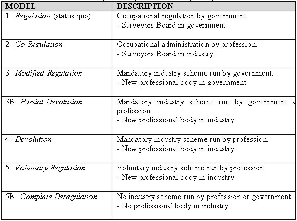
The major role for Government will be to set the standards and quality assure the inputs to the cadastre and the geodetic infrastructure. The Surveyor General's role, in terms of its regulation, is as the principal administrator of land surveying is to develop policy for the active development and maintenance of the cadastral surveying infrastructure. As custodian of the surveying elements of the cadastre, the Surveyor General has primary responsibility for the surveying of boundaries for both Crown and freehold land. This project promises to deliver many benefits to the community, industry, the surveying profession and Government. There will be continued integrity and efficiency of the Victorian land registration system with improvements made to the quality of the data inputs and the physical infrastructure that supports the Victorian cadastre. It is envisaged that more responsive professional administration will result from the Recognised Professional Body (RPB) managing the surveying profession and promoting professional best practice. Surveying customers will have access to better and user-friendly information with a transparent complaint resolution scheme. Victoria will contribute to the development of a national land surveying agenda that will hopefully progress towards a national system of registration and national standards for competency and changes to the cadastre. There is growing support for addressing many land surveying issues in a national context. Most importantly, the RBP will be fully accountable to Government. 7. REGULATORY ROLES AND RESPONSIBILITIES [IN REGULATION]Several models have been developed and documented by the industry and Government partnership for the regulation and administration of surveying in Victoria. The models outline revised roles for both industry and Government and stipulate the domain and responsibilities of the controlling body for registration ie. Surveyors Board or a RPB. The seven models developed facilitate the progressively greater reform of the existing framework. A table of these models from the current regulated system through to complete deregulation is shown in Table 1. Table 1: Seven Models for Survey Reform (Source: Gen Group, 2000)
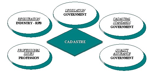
The result of the industry and Government partnership is the development of a preferred model for the regulation and administration of surveying in Victoria. The preferred model is No. 4 - Devolution. However, the final decision is a matter for the Government and will be subject to financial, legislative and policy requirements. Figure 1. depicts the key surveying aspects of the cadastre and the proposed roles and responsibilities of industry and Government in protecting and maintaining its integrity.
Figure 1: Proposed Regulatory Roles and Responsibilities and the Cadastre (Source: Bell, 2000) 7.1 Role of GovernmentThe primary role of Government will be to focus on the setting of policy and standards in order to protect the cadastre. The Surveyor General's role as the principal administrator of land surveying is to develop policy for the active development and maintenance of the cadastral surveying infrastructure. The Reform of Land Surveying Project aims to establish future quality management procedures for surveys that 'change the cadastre', rather than relying solely on the Government regulation of surveyors, as is now the case. Government will set necessary standards and guidelines, and quality assure the inputs to the cadastre and the geodetic infrastructure. The crucial roles and responsibilities of Government within the preferred model include:
7.2 Role of IndustryIt is envisaged that more responsive professional administration will result from a RPB managing the surveying profession and promoting professional best practice. Victoria will contribute to the development of a national land surveying agenda that will hopefully progress towards a national system of registration and national standards for competency and changes to the cadastre. There is growing support to address many land surveying issues in a national context. Most importantly, the RPB will be fully accountable to Government. The RPB would primarily manage the land surveying profession instead of Government. It has been accepted that the practitioners should have responsibility for managing their affairs to extend their skills and expertise, improve the profession's standing in the community and enhance the quality of surveying work, particularly as it affects the changes to the cadastre. 8. CONCLUSIONCadastral or land administration reform is gathering pace throughout the world. FIG has provided major stimulus for reform, capitalising on the growing global trends of investment in land economies and support for sustainable development. Victoria is driving its own cadastral reform agenda. The Reform of Land Surveying in Victoria project will arguably provide the most significant and far reaching changes to the State's surveying industry. The outcomes of this project will fundamentally change the administration of surveying for the first time in almost 150 years, since conception of the State's system of Government. It is timely to remember that land surveyors continue to provide the primary inputs to the cadastre and are the major users of and contributors to the land surveying infrastructure. Land surveyors must continue to ensure that the products and services they produce remain relevant and meet the needs of all consumers, not only in the property-related markets, but also the land information user community. Reform of the regulation of land surveyors is fundamental to cadastral reform. REFERENCES1885 Royal Commission on Land Titles and Surveys, Victoria Bell, K.C., (2000). Cadastral Reform in Victoria. Summary Paper Presented at the Survey Conference 2000, Marysville, Victoria. Bell, K.C., (2000). Intergovernmental Committee on Surveying and Mapping Draft Discussion Paper: Cadastral Reform. Draft response to - Action 99/76 (Agenda Item 6.7.1 Cadastral Reform), Version 1.1. Bell, K.C., (2000). Vision for the Cadastral Surveying Infrastructure of Victoria. Internal Land Victoria Discussion Paper. Land Victoria. Melbourne. Bell, K.C., (2000). Reform of Land Surveying in Victoria: Challenges for Government and Opportunities for the Profession. Paper Presented at the Second Trans Tasman Surveyors Conference 2000, Queenstown, New Zealand. Bell, K.C. and C. J. Lester (1999). Reform of Land Surveying in Victoria: Protecting the Integrity of the Cadastre. Internal Land Victoria Briefing Paper. Land Victoria. Melbourne. Department of Natural Resources and Environment, (1999). National Competition Policy Review of the Surveyors Act 1978: Government Response. Internal Land Victoria Paper, Department of Natural Resources and Environment, Victoria. Department of Treasury and Finance, (1996). Investment Evaluation Policy and Guidelines. Department of Treasury and Finance Internal Guidelines Paper, Victoria. Edwards, N., (2000). Survey Reform in Victoria. Summary Paper Presented at the Survey Conference 2000, Marysville, Victoria. Gen Group, (2000). Survey Reform Government Business Case. Gen Group Internal Summary Paper for Land Victoria, Gen Group, Victoria. Green, R.P., (2000). Rejuvenation of an Ageing Profession. Summary Paper Presented at the Survey Conference 2000, Marysville, Victoria. Jones, A. Rowe, C. and P. Kentish, (April 1999). ICSM Discussion
Paper: Cadastral Reform. Intergovernmental Committee on Surveying and
Mapping. Kaufman, J. and D. Steudler, (July 1998). Cadastre 2014: A Vision
for a Future Cadastral System. FIG Commission 7, Switzerland. Southbridge, (1997). National Competition Policy Review of the Surveyors Act 1978. Southbridge Internal Review paper for Land Victoria, Southbridge, Victoria. United Nations / FIG, (March 1996). The Bogor Declaration. FIG
Commission 7, Bogor, Indonesia. United Nations / FIG, (17-23 October 1999). Bathurst Declaration: Land Tenure and Cadastral Infrastructures for Sustainable Development. FIG, Bathurst, New South Wales, Australia. United Nations / FIG, (October 1999). Technical Papers of the International Conference on Land Tenure and Cadastral Infrastructures for Sustainable Development. FIG, Melbourne, Australia. BIOGRAPHIC NOTEKeith C. Bell was appointed the 24th Surveyor General of the Australian State of Victoria in August 1999. The Office of the Surveyor General Victoria is a division within Land Victoria, of the Department of Natural Resources and Environment. Keith is also the Chairman of the Surveyors Board of Victoria, the Registrar of Geographic Names and is one of Victoria's Commissioners for Electoral Boundaries. Previously, Keith was the General Manager of the Australian Capital Territory Government's Land Information Centre (ACTLIC) for three years and prior to that a senior manager in the Australian Surveying and Land Information Group (AUSLIG) in the Australian federal government. He has also worked in the Queensland State Government. Victoria is currently reforming its regulatory system for land (cadastral) surveying, which includes the introduction of new legislation, regulations and standards. Regulatory reform is a key component of Victoria's broader reform agenda for the cadastre, which is seeing the transformation of largely paper-based information infrastructure into a modern spatial data infrastructure with effective institutional and regulatory frameworks and technology-efficient business processes. Keith has responsibility for the Reform of Land Surveying in Victoria project. In addition, Keith as the Victorian representative on the Intergovernmental Committee on Surveying and Mapping for Australia and New Zealand, is the Chairman of the Cadastral Reform Permanent Committee. His early career included working offshore as a hydrographer and in the geophysical exploration industry. In addition Keith has served in the Australian Army, in both the regular and reserve forces. Originally from the Australian state of Queensland, Keith Bell is a licensed surveyor and chartered professional engineer. He is a graduate of the Queensland University of Technology and in addition holds a Master of Surveying and Mapping Science from the University of Queensland, Master of Business Administration from Deakin University and Graduate Diplomas in Management and Human Resource Management from the University of Canberra. Keith is a Fellow of the Institution of Surveyors Australia (ISAust), the Institution of Engineers Australia (IEAust) and also the Australian Institute of Management (AIM). Also, he is a Member of the American Society of Civil Engineers (ASCE) and the Mapping Sciences Institute of Australia (MSIA). This year, 2001 marks the 150th anniversary or sesquicentennial of the Surveyor General of Victoria. Elizabeth O'Keeffe is the Executive Director, Land Victoria, within the Victorian Government's Department of Natural Resources and Environment. Land Victoria helps Victorians to maximise the economic and social value that can be created from land. Land Victoria has around 800 staff (550 in Melbourne; 250 spread across Victoria), and an annual budget of around $100 million. It generates annual revenues in excess of $140 million. Land Victoria: provides the fundamental surveying and mapping reference framework for the state, and authoritative geospatial (land-related) information; records, maintains and safeguards information about the location and definition of land and its boundaries; provides accurate information by identifying and registering interests in public and private land and supplying valuation information and advice; and provides the framework for the management, use and development of Crown land and ensures a balance between development and protection of natural and cultural assets. Land Victoria's major area of growth is in delivering land information and transactions online. Key information infrastructure projects include: the Land Channel, launched in 1998, which offers integrated land-related information and maps to business and home customers, and will eventually offer full land transaction facilities; automating 2.4 million paper-based land titles to provide faster titles registration and search services and to enable this information to be accessed remotely; a standard parcel identifier project which uses a standard key to bring together information from different datasets about the same piece of land; and a property information project which aims to produce complete land, property and mapping information for Victoria. Future initiatives include: Vendor Statement Online which sets up an electronic collection process for vendor statement and other property information; an E-conveyancing project to bring all elements involved in a property transaction online, including settlement and lodgement. Elizabeth O'Keeffe has previously been responsible for Crown Land Management, corporate resources, portfolio and policy coordination and legislative programs within central and line agencies for the Victorian and Commonwealth Governments. CONTACTKeith C. Bell, RFD Elizabeth O'Keeffe 21 April 2001 This page is maintained by the FIG Office. Last revised on 15-03-16. |