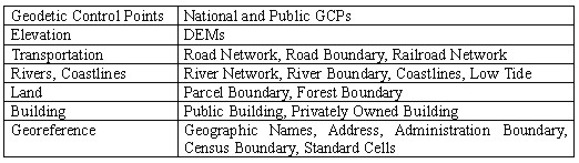
CURRENT STATUS OF GIS RELATED ACTIVITIES IN JAPANKazuo INABA and Eiichi TAMURA, JapanKey words: GIS, Spatial Data Framework, Standard, Clearing House. 1. INTRODUCTIONIn this paper, Japan's recent GIS-related activities are described in its entirety. The paper covers five topics. The first topic is digital map preparation, which was introduced about 25 years ago. At that time, there was no such concept as spatial database, and efficient map digitization was the main research problem. The second topic is a study for the promotion and dissemination of GIS in Japan. Two reports were published in this study and the summaries of the reports are provided. The third topic is recent GIS-related activities by the Japanese government. Information on current activities and the policy of Japanese government are presented in this section. The fourth topic is about the Spatial Data Framework, which was developed under the new concept of spatial database. The fifth topic is about related research activities in our organization. 2. DEVELOPMENT AND PUBLICATION OF MAP DATA2.1. OutlineThe development process of GIS infrastructure in Japan can be explained in four phases. Phase I began in the middle of the 1970s when the government started preparation of digital geographic data for only limited users such as central and local governmental organizations and researchers at universities. Phase II arrived when the Geographical Survey Institute (GSI), Ministry of Land, Infrastructure and transport (MLIT) began to publish digital cartographic data sets in 1993. Phase III started in 1995 when the government reached a consensus that the active encouragement of GIS development was necessary. At present, Phase IV is approaching when the preparation of spatial database in accordance with a standard is important. In this section, phases I and II are explained. Phase III is explained in section 4. Phase IV is described in section 5. 2.2. Development of Digital National Land InformationThe Japanese government has been developing digital geographic information since the mid-1970s. As its initial activity, GSI began to develop the "Digital National Land Information" in 1974 in cooperation with the National Land Agency, and was nearly completed in 1980. Its accuracy corresponds to approximately 1:200,000 paper maps. It consists of DEM, land-use data, boundaries of local governments, major roads, railways, rivers, coastal lines, public facilities, etc. The purpose of this project was to supply basic digital geographic data necessary for national land development planning and regional planning by the central governmental agencies and local governments. It has also prepared the "Detailed Digital Land Use Data" to support the policy making of building land administration in collaboration with the Economic Affairs Bureau of MOC since 1981. It is a data set of grid cells for land use (10m square on the ground) for three major metropolitan areas (Tokyo area, Osaka area, and Nagoya area), and each area is surveyed repeatedly every 5 years. These data sets have been highly reputed for they have enabled quantitative analysis of national land. However, they have been specially prepared for administrative purposes, therefore they have not been disclosed to the public but used only by administrators within the central and local governments and researchers at universities. 2.3. Publication of Digital Geographic InformationIn June 1993, GSI launched into the publication of digital cartographic data sets called the "Digital Map Series". It was extremely epoch-making. Since then, the variation and number of published digital cartographic data and software that apply those data have increased, and as a result, people have gradually come to recognize the benefits of geographic information. Nine kinds of "Digital Map Series" are available at present. They are "Digital Map 10000 (total)," "Digital Map 25000 (shore lines and administrative boundaries)," "50 m mesh (elevation)," "250 m mesh (elevation)," "1 km mesh (elevation)," "1 km mesh (average elevation)," "Digital Map 25000(Map Image)," "Digital Map 2500(Spatial Data Framework)," and "Digital Map 200000 (shore lines and administrative boundaries)". They are text files and distributed via CD-ROM with simple software for quick browsing of the image of inside data. A detail explanation of "Digital Map 2500 (Spatial Data Framework)" is given in section 5. 3. STUDY FOR THE PROMOTION AND DISSEMINATION OF GISToday, the Japanese government is making great efforts towards the development and utilization of GIS, recognizing the necessity and important role of GIS in this highly advanced communications-oriented society. In order to establish new strategies related to GIS, during 1995-96, the headquarters of MOC and GSI have jointly organized the GIS Research Committee which comprises of several professors. 3.1. First ReportThe First Report by the Committee was presented on February 2, 1996. The title of the report is "Plans for the Development of National Spatial Data Framework throughout Japan". Its contents are summarized as follows. 3.1.1. Urgent need for preparation of a National Spatial Data Framework The growth of the "Information Highway" makes it all but impossible to ignore the fact that we have truly entered the computer age, or age of information. Aside from the novel aspects of the information highway, this era offers an unprecedented opportunity to maximize efficiency in social areas. Yet most attention has been focused on the popular aspects of the highway. An equally important factor is the "National Spatial Data Framework". The Spatial Data Framework, which uses geographic information as a base, deals in all data that can be classified geographically. 3.1.2. Spatial Data Framework needs to be standardized It is essential to standardize the Spatial Data Framework in order to ensure efficiency and accessibility in the following three areas. a) Standardization of the National Spatial Data Framework As some public organizations have already made electronic maps, it is highly likely that some will prepare the Spatial Data Framework suited to their unique needs. It is needed to standardize Metadata, which indicates Spatial Data specifications in detail. This standardization, which will be easily referred to, will make it possible for users to judge whether or not it meets their unique needs. b) Standardization of Geo-reference In order to correspond Spatial Data to geographic locations, it is necessary to give precise axis coordinates of latitude and longitude. Most Spatial Data indicates addresses in conventional form. Therefore, it is necessary to shift to geo-reference standards, using an address-matching system which replaces conventional addresses with coordinates. c) Standardization of Software In GIS, which processes Spatial Data, there are various systems at work; these systems are developed to meet individual user needs. However, certain basic functions are used in all systems in common, regardless of user interest. In all probability, standardizing these basic functions would help to broaden the appeal of GIS, thereby promoting its use. 3.1.3. Spatial Data Framework promotion policy a) Sponsorship of the Spatial Data Framework MOC is expected to take a leading role in promoting the preparation and standardization of the Spatial Data Framework. GSI, which is under MOC jurisdiction, is responsible for the country's basic map information, as well as public facilities, such as the nation's roads and rivers. In this endeavor, the Ministry of Construction should work closely with a team of other government agencies. Support will also be offered to regional public offices which, in order to improve their administrative services, will be called upon to prepare minute Spatial Data Framework. To lighten the financial burden of these offices, there will be cost-sharing plans among Spatial Data Framework users, along with financial support from the government. b) Building a system of information exchange A system of information exchange, which will link users and data suppliers in one network, is a viable method with which to address user inquiries. Such a system, referred to as "Clearinghouse," enables users to properly locate and utilize the Spatial Data Framework. c) Renewal of the Spatial Data Framework If the Spatial Data Framework is to be effective in the long run, it will need to be modified or renovated as the need arises. This and other options will require a new framework for the maintenance and administration of the Spatial Data Framework. d) Financing the preparation of the Spatial Data Framework Apart from the initial large investment of money, the Spatial Data Framework will also require funding for management, maintenance, and ongoing modifications. The government should ensure that funds are allocated not only in this endeavor, but also in the basic promotion of the Spatial Data Framework throughout the country. e) International standard As the growth of information systems or the worldwide web is creating a new era in which people can access information in real time regardless of distance, an international standard on geographic information must be sought. To this end, Japan is participating in the international standardization activity of the ISO (International Organization for Standardization) on GIS. Such participation in international standardization projects, as well as close cooperation with domestic fields such as business and academia, should be supported and encouraged continuously. f) Conversion of accomplished concept The Spatial Data Framework will, in the foreseeable future, eliminate the need for paper to be used to transmit information formally; instead, information, such as maps or any paper documents, will be transmitted electronically. Aside from being more efficient, such changes will serve to promote the use of Spatial Data Framework. g) Preparation of an information communication network In order to expand the utilization of GIS, there is a pressing need for the preparation of a high capacity information communication network, such as the optical fiber network. 3.2 Second ReportThe Second Report was disclosed on May 30 the same year, which states: 3.2.1. Need for GIS introduction GIS is the most important information system that utilizes the rapidly-developing Information Highway. It is indispensable for executing high quality administrative services in diverse fields such as registration affairs, supplying administrative information to the citizens, information exchange among administrative organizations and regional inhabitants, and crisis management in the case of a disaster. In order to guarantee a rich and comfortable social life, and to realize effective and highly transparent administration, administrative organizations should immediately establish Spatial Data Infrastructure and tackle appropriate measures for the importation of GIS . 3.2.2. Administrative measures to be taken place Spatial Data Infrastructure is so important in the era of the Information Highway that official bodies, such as GSI, facility administrators, local governments, and public utility enterprises, should take the lead to develop it. It is necessary for the central and local governments to discuss the establishment of a new framework for the effective revision of Spatial Data Infrastructure that can be achieved automatically through their respective routine activities, so as to assure the mutual utilization of revised information. Besides, in order to secure mutual and flexible use of various informations, it is essential to standardize metadata and location referencing by liaisoning with international standardizing activities. Government, local governments, and the private sector should widely recognize that spatial data, which are prepared by themselves under the proper standards, have important meaning as infrastructure, and should open it to the public. In order to obtain information on the existence of these data and share their benefits, a system that connects data creators, managers, and users via network, namely a clearinghouse, should be established. Measures for the accelerating the positive utilization of GIS by administrative organizations, development of a high-speed communication network, and necessary legal institutions should be discussed. It is desirable that GSI, together with other governmental organizations, local governments, and facility administrators, promote the preparation of the Spatial Data Framework, and complete it for the most part by the beginning of the 21st century. 3.2.3. Immediate actions for the promotion of the above-mentioned measures In order to promote the policy so that it can be dealt with smoothly, it is necessary to start a model pilot project to encourage the understanding and popularization of GIS and Spatial Data Infrastructure, clarify institutional and technical issues for the promotion of mutual utilization of Spatial Data Infrastructure, and take measures to solve those issues. Through these reports, the Committee clearly indicated the importance of GIS for the development of society, and the government was requested to make increased efforts towards the development of Spatial Data Infrastructure and standardization of spatial data for GIS. 4. RECENT GIS-RELATED ACTIVITIES BY THE JAPANESE GOVERNMENT4.1. Liaison Committee of Ministries and Agencies Concerned with GISA Liaison Committee of Ministries and Agencies Concerned with GIS was established in September 1995 to promote the efficient development and effective utilization of GIS within the Government with the close cooperation among the Ministries and Agencies. The Cabinet Councilor's Office, Cabinet Secretariat, was designated as the secretariat of the Liaison Committee, and assisted by the Geographical Survey Institute (GSI) and the National Land Agency (NLA). The Committee has two task force groups, i.e. Spatial Data Framework Task Force Group and Basic Spatial Data Task Force Group, each of which has a few working groups to discuss more specific topics in detail. 4.2. Long-term Plan for the Development of NSDI in JapanThe Liaison Committee developed a Long-term Plan in 1996 for the development of NSDI in Japan. The Plan specifies actions to be taken by the Government during a two-phase period starting in 1996 up to the beginning of the 21st century. The first phase focuses on the definition of NSDI in Japan as well as standardization of metadata and clarifying the roles of the central government, local governments, and the private sector, rather than actual spatial data development. The implementation of NSDI including spatial data development for NSDI is expected to take place in the second phase. Approximately three years have been designated for each phase, i.e., first phase (1996-99) and second phase (1999-2001). 4.3. Pilot Study by Local Governments for the Implementation of the Long-term PlanThe definition of NSDI, one of the main subjects of the first phase of the Long-term Plan, requires intensive research on the availability, utilization, restriction and distribution of maps and spatial data in local governments, because they develop and maintain most of spatial data sets in Japan. GSI and NLA are conducting a collaborative pilot study in fiscal year(FY) 1997 with four local governments to do such research. The main topics of the pilot study include: which spatial data item should be included in the Spatial Data Framework of the Japanese SDI; who should develop and maintain such data items; and which information would be most suitable for indirect georeferencing. The result of this pilot study was summarized in Interim Report of the Long-term Plan at the end of FY 1997. Additional Ministries, i.e., the Ministry of International Trade and Industry (MITI), the Ministry of Posts and Telecommunications (MPT), and the Ministry of Home Affairs (MHA) joined the pilot study in FY 1998 starting in April 1998. The research topics of these Ministries in the pilot study are as follows: MITI will develop new information systems with GIS and foster related industries; MPT will focus on the development of a spatial data search engine through computer networks, spatial data encryption methods to protect private information, and spatial data compression for efficient data distribution; and MHA will investigate technological and institutional issues of local governments related to NSDI development. The results of these pilot studies were incorporated into the final report of the first phase of the Long-term Plan, which will direct the implementation of NSDI during the second phase. 4.4. Interim Report on the Implementation of the Long-term PlanThe Committee compiled an interim report on the activities during the first two years of the first phase of the Long-term Plan. The report reviews the subjects specified in the Long-term Plan and the actions actually taken by the Committee. It also clarified the issues to be focused on by the Committee during the last year of the first phase. The report was published and distributed to the public at the end of March 1998. 4.5. Final Report of the First PhaseThe Committee adopted the Final Report of the First Phase of the Long-term Plan on March 30, 1999. The Final Report entitled "Standards and Development Plan of National Spatial Data Infrastructure" includes two standards of Japanese NSDI (i.e., a technical standard that is based on ISO/TC211 standard drafts, and a list of data items adopted as the framework data) and a development plan for the second phase of the Long-term Plan. The technical standard included in the Final Report was developed through collaborative research between the Geographical Survey Institute and 53 private companies during the three-year research period starting 1996 and second phase is now continuing (explained below). Table 1 shows the list of data items for the Japanese framework data. Table 1. List of Data Items for Spatial Data Framework
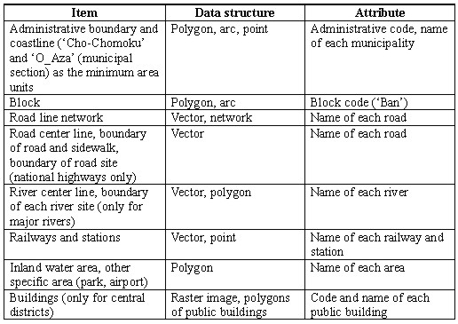
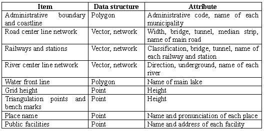
5. PREPARATION OF SPATIAL DATA FRAMEWORK*Together with these activities, GSI has prepared a new type of digital cartographic data sets called a Spatial Data Framework (SDF). There are two types of SDF. One is SDF2500 which is for city planning area for all of Japan, the other is SDF25000 which is for whole Japan. 5.1. SDF2500Table 2 indicates the content of SDF2500. Table 2. Contents of the Spatial Data Framework 2500
Data development area for each year is as follows.
The characteristics of these data sets are that they:
The data sources for these files are:
These data sets have been published from April 1997 for the use of unspecified individuals at an appropriate price, just as the Digital Map Series. They are also distributed free of charge to every local government that provided data sources. The whole planned area was covered in March 2001. 5.2. SDF25000Table 3 indicates the content of SDF25000. Table 3. Contents of the Spatial Data Framework 25000
Data development started in 2000 and is expected to complete in 2002. SDF25000 covers whole area of Japan and will be published from October of 2001. 6. STANDARDIZATION OF GIS DATA6.1. International standardInternational organization for standardization (ISO) started established Technical Committee for GIS standard(TC211) in 1994. TC211 has been continuing discussion on this issue. Japan participated in ISO/TC211 from the beginning of this activity and contributed to the development of standards. The ninth plenary meeting was held in Kyoto on September 1999, and the twelfth plenary will be held in Lisbon on March 2001. 6.2. National Standard of JapanBased on the need to develop a GIS standard for Japan, which is in accordance with that of ISO/TC211, GSI started research on Japan's GIS standard in 1996. This research was also intended to provide a technical backbone for the Japanese SDI standard discussed by the Liaison Committee of the Government. Fifty-three private companies joined this three-year research project funded by the Ministry of Construction as one of the projects of the collaborative research program with the private sector. Two kinds of standards were developed through this research: spatial data exchange standard and spatial data development standard. Six working groups were established for the exchange standard to discuss 8 work items including data structure, data quality, georeferencing, metadata, and cataloguing. Spatial data development standard includes a guideline to develop specifications for spatial data development contracts. The final draft of the standard was developed at the end of FY 1998 and adopted as part of the NSDI Standards by the Government Liaison Committee. After completion of the final draft in FY 1998, GSI and thirty three private companies entered into the second stage of this research activity. The goal of second stage is to refine the draft produced in FY 1998 and make it available in practical use. The guideline for a product specification of GIS data is also being developed in this second stage. 7. OTHER ACTIVITIES OF THE GEOGRAPHICAL SURVEY INSTITUTE7.1. Research on Development of Geographic Information Directory Database (GIDD)The Long-term Plan developed by the Government pointed out the necessity for National Spatial Data Infrastructure and specifies the need to establish a clearinghouse system for spatial data. GSI has been developing a Geographic Information Directory Database (GIDD) as a five-year research project since April 1994. This database is designed to provide directory information (i.e., metadata) of spatial data through computer networks, and to become a clearinghouse node by developing a search environment of distributed databases. The metadata standard, which is currently used in the GIDD, is developed as one of the work items of the Spatial Data Exchange Standard of "Research on GIS Standardization" described above. This standard can be considered as the Japanese localization of ISO/TC211 15046-15115 Metadata by making modifications on, for example, spatial reference, addressing, and language (i.e., Japanese). A prototype of GIDD with limited search capability is now in the process of practical testing. This prototype provides 229 records, experimental metadata of Digital Map 10000 (Total) in Japan. GIDD has the ability to make a query using 12 attributes such as title, keyword, longitude, latitude, and producer as well as a combination of these attributes using logical operators. Retrieval result will be shown in a list of URL and we can retrieve metadata through WWW. The URL of GIDD is http://giddsurv.gsi-mc.go.jp/gidd/. Based on the result of these tests, we will enhance its search capability and support distributed environment. 7.2. 3D GIS Study with AUSLIG and the University of AdelaideThis cooperative research, started in 1997, has two main purposes. One is to develop a precise three dimensional measurement system of urban features using an airborne laser. Compared with conventional photogrammetric methods, this system enables us to acquire 3D data with high spatial and temporal accuracy. GSI mainly takes charge of this study. The other, mainly pursued by the Australian side, is to develop an interactive 3D GIS model for urban planning. A prototype has been already created. This study aims to improve the user interface by embedding data and scientific models within the current 3D GIS environment to allow creation and then verification of urban planning scenarios in real time. 7.3 Clearing HouseA Clearing House is one of important tool for finding and using of geographic data. In Japan several organizations are developing their clearing house. GSI has developed its clearing house and opened it March 2000. The clearing house adopts Z39.50, so we can retrieve geographic data from sites located in many countries through this clearing house. The concept of this function is illustrated in Figure 1(next page). 8. CONCLUSIONDevelopment of geographic information infrastructure cannot be achieved without collaborative efforts by all the worldwide organizations and individuals concerned. We hope our experiences might be helpful for the development of geographic information infrastructure of other countries.
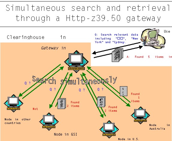
Figure 1 Clearing House developed by GSI REFERENCE
BIOGRAPHICAL NOTEKazuo Inaba has graduated from Tokyo University in 1977 and entered into Geographical Survey Institute in 1979. He is now the Head of Planning Division, Topographic Department. Eiichi Tamura has graduated from Tohoku University in 1991 and entered into Geographical Survey Institute in 1993. He is now Deputy Head of Topographic Division, Topographic Department. CONTACTKazuo Inaba Eiichi Tamura 14 April 2001 This page is maintained by the FIG Office. Last revised on 15-03-16. |