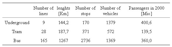
SPATIAL INFORMATION MANAGEMENT (SIM) FOR BERLIN URBAN TRANSPORT SYSTEMDr. Martin SCHEU and Detlef ROSENBAUM, GermanyKey words: 1. BVG - THE LARGEST GERMAN LOCAL PUBLIC TRANSPORT COMPANYThe Berlin Transport Authority (BVG) is the largest municipal public transport system in Germany. The BVG transport system consists of underground lines, tram routes and bus routes [Table 1]. The BVG supports public transport for more than 3,3 Mio inhabitants in the area of Berlin and Brandenburg and spreads over 1000 km².
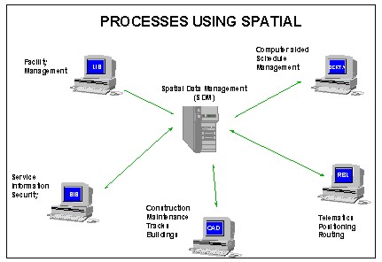
Table 1: Transport capacity of BVG The customer-oriented company concept of the BVG concentrates on providing extensive service, cleanliness and safety. The 14.500 employees of the BVG endeavour every day to ensure that passengers arrive at their destinations on time and in a comfortable manner. In addition, the BVG regularly renews its fleet of vehicles and introduces comprehensive technical innovations, such as a computer aided operating and guidance system (RBL). The BVG passenger guidance system in the uniform corporate design and special displays in the vehicles, such as route indicators, makes orientation on the Berlin transport network easy and comfortable. 2. BVG - PROCESSES USING SPATIAL DATAVarious BVG-processes generate certain spatial data, which are important for the entire company. One of the main tasks is the harmonisation of these different GIS-applications [FIG.1]. Harmonising and combining different spatial data sources, supported by modern internet/intranet -technologies, offers process acceleration. The BVG-GIS-project started in 1997 analysing all existing GIS-applications and data sources. Since 1998 first implementation steps using relational database management system (RDBMS) and web technologies have been carried out.
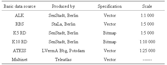
Fig.1: Harmonisation of GIS-applications 3. GEO-REFERENCED BASIC DATA SOURCESBVG-GIS differs between two types of spatial data sources. Basic data are produced and distributed by external institutions [Table 2]. Due to existing contracts all basic data are licensed for shared use in the entire company.
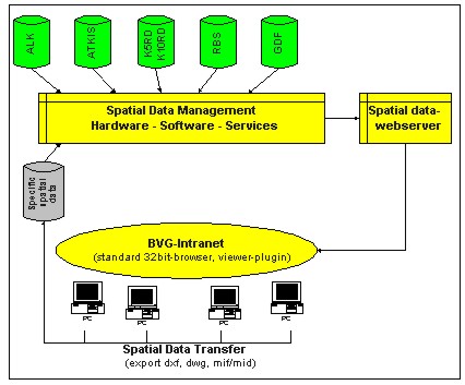
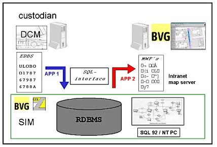
Table 2: Basic data sources used by the BVG Asset data describe company facilities and the transport network. These data are explored from existing applications and transferred to the spatial information management. 4. BVG GIS AND DISTRIBUTION STRATEGYThe BVG IT-network includes nearly 3.000 PC-clients. A company intranet supporting WWW-services has already been established. Using this existing IT-infrastructure, investment for GIS-implementation and data distribution will be minimised. Also costs for training and information distribution are reduced because BVG staff are used to intranet-applications. BVG GIS is easy to use and meets the requirements of the staff. Distributing and visualising of spatial data comprises the following components [Fig. 2]:
Spatial Information Management (SIM) is a complex strategy (SCHEU, 2000), this paper focuses on the management of Berlin´s Digital Cadastral Map (ALK-vectordata). BVG-GIS depends in particular on DCM as the major basic topography.
Fig.2: Distribution and visualisation components BVG-GIS uses standard tools providing following features [Fig.3]:
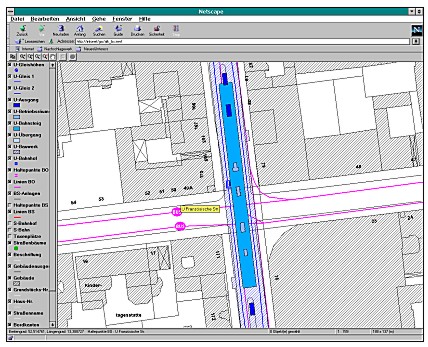
Based on the ALK basic topography the integration of specific spatial data has been started in march 1999. Full operability of BVG GIS was achieved at the end of 1999 (ROSENBAUM & SCHEU, 2000).
Fig.3: Screenshot from BVG-GIS-solution 5. FIRST DATA TAKE ON AND UPDATE OF DCMBVG uses GIS to map and associate their assets to the boundaries depicted in the digital cadastral map. First data take on of DCM processed 1.4 Mio features with 9 Mio points and 8 Mio arcs. These data were transferred by ASCII-filesystem (1.2 GB in format EDBS). An SQL-interface pre-processed and stored the data in a relational database management system.
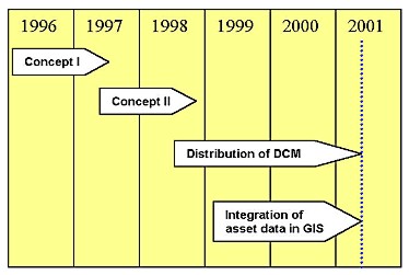
Fig.4: Incremental update and SIM In the past changes have been transferred by supplying the users with a refresh copy of their complete map base. Alternatively the supply of refresh copies for lesser areas based on tiles or other predefined areas were also used. These refresh methods effectively hid the changes from the users who required a more transparent update method to allow an assessment of the impact of the changes on associated spatial data. BVG uses an incremental update, its benefits are clearly argued by DOMINGUEZ et al. (1994). Since 1998 the ongoing process of maintaining the currency is handled in this incremental process, referring to unique feature identifiers (UFI) (HESSE & JACOBY, 1995). 6. CONCLUSIONSBVG GIS implementation is divided into four steps shown in figure 5. Establishing of intranet GIS and basic data distribution is finished. Integration of specific data takes place in different departments. One of the main tasks for the future is to ensure the topicality of basic and asset data.
Fig. 5: Implementation steps of BVG-GIS GIS is used as a strategic tool in most companies. BVG realises several projects (RBL, BERTA, LIS, FAHRINFO), which are using geo - referenced data from different sources. GIS technologies are supporting various purposes. They are useful tools to increase the value of spatial data by combining basic and asset data sources. REFERENCESDOMINGUEZ, G.; LAWFORD, G.; WILLIAMS, D. and CARROLL, D.: The Generation of Incremental Updates and their Role in Helping Your System's Bottom Line. Proceedings of AURISA 94, the Annual Conference of Australasian Urban and Regional Information Systems Association Inc. Sydney, Australia. November 1994. HESSE, W. and JACOBY, S.: Incremental Updates, Unique Feature Identification and Version Management in Modern GIS. Proceedings of AURISA 95, the Annual Conference of Australasian Urban and Regional Information Systems Association Inc. Melbourne, Australia, 1995. ROSENBAUM, D. and SCHEU, M.: Strategy for and Implementation of a Company-wide GIS, GIM International, Vol. 14, No. 10, page 56-57. SCHEU, M.: Geo-Informationssysteme mit großmaßstäbigem Anwendungsbezug, Habilitationsschrift, DGK Reihe C, Dissertationen, Heft Nr. 522, München 2000. SCHEU, M.; EFFENBERG, W.; WILLIAMSON, I.: Incremental update and upgrade of Spatial Data, Zeitschrift für Vermessungswesen (ZfV) Vol. 125, No.4, page 115-120. BIOGRAPHICAL NOTEDr. Martin Scheu received his Dipl-Ing. in surveying in 1990 and a Ph.D. in GIS in 1995 from the Technical University Berlin. After finishing his postdoctoral thesis in 2000 he was appointed as head of the grit branch office in Berlin. His special area of work involves the capture and maintenance of spatial data in GIS. He is a core member of the FIG task force on standards and member of the national DVW-Working Group 3 (SIM). Dipl.-Ing (FH) Detlef Rosenbaum holds the diploma of mechanical engineer from the Technische Fachhochschule Berlin. He started his career in industry in 1984 introducing integrated computer based technologies in design and production. Since 1996 he is teamleader GIS at Berliner Verkehrsbetriebe (BVG). CONTACTDr.-Ing. Martin Scheu Dipl.-Ing (FH) Detlef Rosenbaum 30 April 2001 This page is maintained by the FIG Office. Last revised on 15-03-16. |