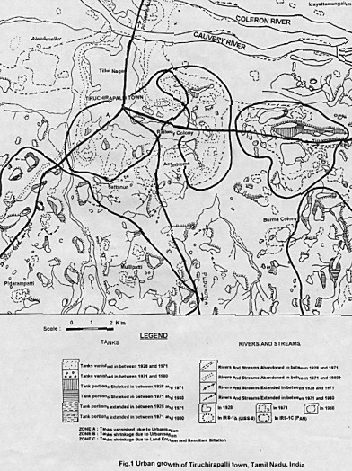
MONITORING URBAN EXPANSION OF TIRUCHIRAPALLI TOWN OF TAMIL NADU STATE, INDIA USING IRS-1C SATELLITE DATADr. Sankaran RAJENDRAN and V.A.CHANDRASEKARAN, IndiaKey words: Urbanisation, Water Resources, IRS-1C, Tiruchirapalli Town, India. AbstractUnplanned city growth is an indicator of rapid industrialization, which usually reduces the quality of the environmental health of a region - sometimes disastrously. Monitoring provides the planners and decision - makers with required information about the current state of development and the nature of changes that have occurred. The study on development of urban lands and the changes in the surface water resources in and around Tiruchirapalli town, Tamil Nadu has been monitored by using IRS-1C PAN (1:25,000; 1997), IRS-1A LISS-II (1:50,000; 1989) satellite data, Aerial Photos (NRSA, 1:20,000; 1979), the Town and Country Planning map (1980) and Survey of India Toposheets (1971 and 1928) with limited field checks. The study highlights the changes in urban development changing the surface water resources. Mapping of the surface water and urban resources in the study area have been interpreted in view of developing urban land and different zones were identified viz. zones A, B and C which are illustrate the changes in surface water resource due to urban growth. 1. INTRODUCTIONIn India as well as in most developing countries, the excessive growth in population and the increased trend towards urbanization have led to many evils such as haphazard growth of industries, unplanned housing and utility networks, conversion of precious agricultural and forest land into urban land etc. Urban Land is one of the important resources provided to man by which necessary human activities are performed. An-accurate and up to date information about the urban land is indispensable for scientific planning and management of urban resources of an area taking into consideration the potentials and the constraints to the environment. The rational planning and management of urban is possible through the regular survey of the land use helps in delineating land suitable for various activities. The IRS-LISS and PAN sensor provides high ground resolution and specified spectral resolution data for detailed studies of urban land use and for monitoring land use changes. This study was undertaken for mapping the unplanned development in the Tiruchirapalli town region including its peripheral zones using IRS data and to provide up to-date information to the planners so as to fill up the gap between urban growth and information collection process. The fundamental problem involved in producing accurate land use maps of urban areas arises from the fact that urban areas are complex assemblages of a disparate set of land cover types including man-made structures, vegetation types and water bodies - each of which has different spectral reflectance characteristics. In visual analyses of remotely sensed images, particularly aerial photography, the spatial pattern of these land cover types is often used to distinguish between categories of urban land use. For example, their particular mixture of buildings, roads, grass and trees can often recognize residential areas; by contrast, parkland is primarily composed of grass and trees (Barr 1992, Tonjes 1999). Recently, several studies have attempted to use the spatial mixing of land cover types within urban areas as a means of mapping land use. The studies by Whitehouse (1990) and Barnsley et al.(1991) have utilized various forms of (per-pixel) spatial re-classification techniques applied to an initial (land cover) segmentation of urban areas. The fundamental basis of these techniques is that it is possible to obtain some measure of the density and distribution of land cover types that is characteristic of a particular urban land use (Barnsley et al.1991). Grouping pixels with different class (land cover) labels on the basis of these measures can therefore delineate areas of similar land use. All three studies attempt this through the use of a type of convolution kernel which either sums the density distributions of the constituent cover types (White house 1990) or measures their spatial arrangement (Barnsley et al.1991) within the kernel. Although promising results have been obtained using these algorithms, the use of a pre-defined kernel places an undesirable restriction on the nature of the spatial searching employed. In particular, it is doubtful whether a single kernel of any size can adequately characterize the complex spatial distribution of the cover types contained in all of the land use categories likely to be found within a typical urban scene (Barr 1992, Tonjes 1999). Besides using pixel-based approaches for image segmentation, we could use road and other linear features that can be derived from GIS data in image segmentation to support land use classification. The conventional pixel-based approaches for land use classification can be applied in a first step. The results will be used as indicators to determine the possibilities that an area, which is surrounding by linear feature from GIS data, can be classified as a certain class. Further measurements will be made based on types of land cover, derived by a pixel-based approach, as well as the proportions and compositions of each type. Since a number of those indicators are not fit the normal distribution, a fuzzy approach can be deployed to assess classification reliability (Molenaar 1996, Hootsmans 1996, Cheng 1999a). 2. GEOGRAPHY OF THE STUDY AREAThe present river Cauvery lights the study area Tiruchirapalli town situated in Tiruchirapalli District, which is one of the important rivers in Tamil Nadu (Fig.1). The study area covers the part of toposheets of Survey of India (1971) No.58 J/9, 10, 13, 14 within the 10o41' - 10o52' North lattitudes and 78o37' - 78o50' East longitudes. It is centrally located in Tamil Nadu state, India. The northern part of the area is a vast stretch of flat flood plains of Cauvery alluvium with morphology associated with meandering river system. The slope of the area is 1 to 2 degree (very gentle). It is 280m above Mean Sea Level. The soil types of the study area are river alluvium, red sandy soil, black soil and red soil. The Cauvery and its branch Coleroon are the most important rivers in this area. Eighteen kilometers west of Tiruchirapalli town, the river Cuavery splits into two branches, of which northern branch called Coleroon while the southern branch retains the name Cauvery. It falls within the Tiruchirpalli taluk and the most of the study area covers the Manachanallur, Andanallur, Thiruverumbur blocks of Tiruchirapalli districts. The average annual rainfall is 700 mm. The temperature is generally very high during summer and it ranges from 29.1 to 38.2 degree Celsius. According to 1998 census, the total population of the Tiruchirapalli town is around 24 lakes of which 71.52% are workers and the rest are a non-worker. The area has a good transport system of road network and well connected by the adjacent towns namely Tanjore, Perambalur, Namakkal, Madurai and Pudkottai. It also has the good communication facilities. Geologically, the region mainly comprises of charnockites, gneisses and granites of Early Proterozoic age. Thin strips of recent alluvium occur on either side of the rivers Coleroon and Cauvery, which flow in an easterly direction in the northern part of the study area. Ground water occurs under phreatic conditions both in the alluvium and the weathered crystalline and the depth to water table ranges between a minimum of 0.4 m and a maximum of 17.85 m (Sathyamoorthy et.al, 2000) 3. MATERIALS AND METHODSIt is important the planning for the growth of cities and to study the growth tendencies in its relation to the physical environment. In this frame, conventional techniques, i.e. the analysis and interpretation of aerial photography has demonstrated its 'applicability to map urban areas, as seen in Santos et al.(1981), Welch (1982). The use of remote sensing techniques together with Geographic Information Systems (GIS), became more and more fundamental instruments for the analysis of urban phenomena and to obtain relevant information for the physical planning of the territory, as shown in works by Foresti (1990), Escada (1992), Vieira & Kurkdjian (1993), Costa (1996), Valerio Filho (1998)and Serafim (1998). So, the objective of this paper is to monitor the dynamics of urban growth in areas of the occupation, using remote sensing technique. In the present study, the IRS-1C PAN (1:25,000; 1997), IRS-1A LISS-II (1:50,000; 1989) satellite data, Aerial Photos (NRSA, 1:20,000; 1979), in the form of paper print and diapositive supplemented by Survey of India (SOI) topographic maps (1971 and 1928) and maps prepared by the Town and Country Planning, Tiruchirapalli (1980) have been analysed with limited field checks which led to delineation of various changes in urban land use categories. The data were interpreted visually and as well as analysed through computer techniques. The satellite images were interpreted with the elements of image interpretation such as shape, size, tone, texture, pattern, site and association. (Compbell, 1987). The IRS-1A LISS-II (FCC) diapositive was enlarged optically with the instrument Procom to the scale of 1:50,000 and further enlarged and super imposed on the other IRS-1C PAN data hard copy imagery. Different types of urban land use categories were transferred on the standard base map prepared with SOI toposheet and Town and Country Planning, Tiruchirapalli. The changes in land use and land cover were finalized on the basis of ground verification with the help of town map of Tiruchirapalli on the scale of 1:12,500. 4. RESULTS AND DISCUSSION4.1 Development of Built-up LandsThe interpretation of multi-date satellite and other data helped in the preparation of urban sprawl map of the study area. The study of the spatial growth of the city over the years has revealed that the built-up area has spread along the five main transportation corridors in a radial pattern viz. Tanjore, Madurai, Pudukottai, Dindugal and Perambalur, in the process devouring agricultural lands and water bodies. The decrease in agricultural area is due to conversion of urban land use or discontinuation of agricultural lands and water bodies is more apparent to urban uses. The loss of these agricultural lands and water bodies is more apparent towards the east, south and south-west of Tiruchirpalli town where the town growth is more. 4.2 Expansion of Tiruchirapalli townThe industrial development in the Tiruchirapalli town is parallel with the urban expansion, which became the dominant characteristic of the spatial organisation. This characteristic can be seen both in the increase of urban population as well as at the territory occupied by these activities. Being so, it is necessary to know the features and effects of urbanization to understand the significance of this phenomenon but also to gather information for urban and regional planning. The population of Tiruchirapalli Town has increased to 14% in 1961, 23% in 1971 and 17% in 1981. The increase in 1971 is much high. The increase in population caused heavy demand for residential house, which reflects the development of housing colonies. The urban development of this town is very fast in 1971 because of the growth of residential, commercial, industrial and recreational lands. Up to 1997, the changes in the urbanization are not many however little changes existed (Fig. 1) and 1971 onwards the development has been steady. The cross references about the Housing Board and private colony development analyses show in 1971, the number of house sites are 1630 and after 1982 it has increased to 2527 sites and it represents the fast growth of urban development of this town (Annammal, 1989). In this study, the interpretation shows that the residential and commercial lands have also developed, where as the tanks and rivers have dried up. 4.3 Changes in Surface Water ResourcesIn the present river Cauvery, the depletion in the surface water resources in rivers and tanks has been identified and it is caused by the growth of urban lands, land erosion, siltation, etc. Developing of building lands necessitates the filling up to tank beds and river portions. Negatively, it changed the surface water resource. Hence, the decreasing of annual rainfall and increasing city population is also cause such changes. Changes in rivers and streams are clearly indicating the variation in the rainfall (Sathiyamoorthy, 1991). The mapping of the surface water resources change in the study area has been interpreted. Figure.1 shows the different zones (zones A, B and C), which illustrate the urban growth. The details are as follows. ZONE - A: Zone -A is the heart of the city, in which the development of building lands, has caused the disappearance of tanks. ZONE - B: Development of building lands in tank areas creating the shrinkage of tanks. ZONE - C: Development of buildings and industries, land erosion and siltation causing the shrinking of tanks. From the interpretation, it is observed that the moderate growth of towns in the study area. The intra and inter-regional variations were less in the growth of towns. The town is recorded with moderate to fast urban growth. This was owing to the industrial concessions given to backward regions. The large towns in the area are increased by the commercial and industrial activities. The regional variation is not sharp. The intra-regional variations in growth are mainly associated with acceleration of economic activity, transportation network, administrative and government interventions. 5. CONCLUSIONThe results of this study based on IRS data suggest that visual interpretation of imagery is reliable and effective technique for detection of urban change. The mapping of the urban developments and surface water resources in and around of Tiruchirapalli town has been studied, which shows the development of urban lands had brought changes in surface water resources. Effective conservation measures are to be taken to safeguard the agricultural lands, water bodies, natural forest cover, etc. from depletion and for its optimum utilization. Similar studies can be under taken for other cities also to estimate the quantum of damage caused to the environment by urbanization for its effective management. ACKNOWLEDGEMENTAuthors are highly thankful to Director, Institute of Remote Sensing, Anna University, Chennai and the Director, Town and Country Planning Office, Tiruchirapalli for their kind help in providing reference data and valuable suggestions. APPENDIXFig.1 Urban growth of Tiruchirapalli town, Tamil Nadu, India
REFERENCESAnnammal (1989) "Environmental Management in Tiruchirapalli Municipal Area" semi on the state of Tiruchy Environment, Bharathidasan University, Trichirapalli - 23. 25 -51. Barnsley, M.J., Barr, S. L., nd Sadler, G. J.,1991 Spatial Re-classification of Remote Sensed Images for Urban Land Use Monitoring. Proc. Spatial Data 2000, 17-20 September 1991,Oxford University, (Nottingham: Remote Sensing Society), 106-117. Barr, S. L., 1992. Object-based Re-classification of High Resolution Digital Imagery for Urban Land-Use Monitoring. International Archives of Photogrammetry and Remote Sensing (ISPRS, Washington, D.C.1992). Vol. XXIX, Part B7, Commission VII,969-76. Compbell James C (1987) "Mapping the Land Aerial Imagery for Land Use Information" Scientific Publishers, 4 Cheng, T., 1999a. A Process-Oriented Data Model for Fuzzy Spatial Objects. Ph.D. Thesis Wageningen Agricultural University (WAU), ITC, Enschede, The Netherlands, ISBN 90-5808-038-2,ITC Publication 68 Costa, S.M.F.,1996.Metodologia alternativa para o estudo do espaço metropolitano, integrando as tecnologia de SIG e sensoriamento remoto -Aplicação à área metropolitana de Belo Horizonte. São Paulo. Dissertação de Doutorado - Escola Politécnica da Universidade de São Paulo.179. Escada,M.I.S.,1992.Utilização de técnicas de sensoriamento remoto para o planejamento de espaços livres urbanosde uso coletivo.(Dissertação de Mestrado em Sensoriamento Remoto)- INPE,São José dos Campos,133, (INPE-5441-TDI/487). Foresti,C.,1990.Proposta metodológica para o estudo ambiental e da estruturação do espaço urbano em áreas metropolitanas. In: SIMPÓSIO BRASILEIRO DE SENSORIAMENTO REMOTO,6.,Manaus,AM.24-29 jun., Anais. 2, 336-340. Hootsmans, R.1996. Fuzzy Sets and Series Analysis for Visual Decision Support in Spatial Data Exploration. Ph.D. Thesis Utrecht University, The Netherlands, ISBN 90-6266-134-3. Molenaar M., 1996. A Syntactic Approach for Handling the Semantics of Fuzzy Spatial Objects. in: Burrough P. A. etal. (Eds),Geographic Objects with Indeterminate Boundaries, 207-224, London: Taylor &Francis Ltd. Mumbower, L.; Donoghue, J., 1967. Urban poverty study. Photogrammetric Engineering, 33(6): 610-618. Santos,A.P.;Foresti,C.;Novo,E.M.L.M.;Niero,M.;Lombardo,M.A.,1981.Metodologia de interpretação de dados de sensoriamento remoto e aplicações no uso da terra.São José dos Campos,INPE.61 (INPE-2261-MD/016). Sathyamoorthy S. (1991) "Integrated Ground Water studies in and around Tiruchirapalli, Tamil Nadu" Published Ph.D Thesis, Bharathidasan University, Tiruchirapalli - 24. Sathyamoorthy, Subramanian.Vand Balasubramanian. A (2000) Groundwater resources evaluation in and around Tiruchirapalli, Tamil Nadu, Proceedings of the "Ground Water xploration Techniques" National College, Tiruchirapalli, 208-217. Serafim, C. R.,1998 Monitoramento do crescimento urbano em áreas de risco à erosão na bacia hidrográfica do córrego Pararangaba no município de São José dos Campos-SP.(Dissertação de Mestrado em Planejamento Urbano eRegional-UNIVAP),São José dos Campos.99. Tonjes, R., Growe S., Bucker J.and Liedtke C.-E.,1999.Knowledge-Based Interpretation of Remote Sensing Images Using Semantic Nets.Photogrammetric Engineering &Remote Sensing , 65, 811-821. Valerio Filho,M.,1998.Técnicas de Sensoriamento remoto e geoprocessamento aplicadas ao planejamento regional. VI Simpósio Nacional de Controle de Erosão.Presidente Prudente,São Paulo.CD-ROM. Vieira,I.M.;Kurkdjian,M.L.N.O.,1993.Integração de dados de expansão urbana e dados geotécnicos como subsídio ao estabelecimento de critérios de oupação em áreas urbanas. In: SIMPÓSIO BRASILEIRO DE SENSORIAMENTO REMOTO, 7. Curitiba,PR. Anais. Curitiba.v. 1,.163-171. Welch, R., 1982. Spatial resolution requirements for urbans studies. International Journal of Remote sensing, 3(2): 139-146. White house, S., 1990. A spatial land use classification of an urban environment using high resolution multispectral satellite data.Proc.16th Ann. Conf. Remote Sensing Society, Remote Sensing and Global Change, University Collage Swansea,19-21 September 1990,(Nottingham: Remote Sensing Society),433-437. BIOGRAPHICAL NOTESankaran Rajendran (32) CONTACTDr.Sankaran Rajendran 30 April 2001 This page is maintained by the FIG Office. Last revised on 15-03-16. |