News in 2021

|
Spatial data for efficient land management
2 September 2021, Vladivostok, Russia
Rosreestr, UNECE/Working Party for Land Administration (WPLA), FAO
and FIG presented their activities at the VI Eastern Economic Forum in
the panel discussion “Digital Twin. The Future of Spatial Data”
The article is edited by Rumyana Tonchovska, UNFAO and is a brief
report on the opinions, news and best practices presented at the panel
discussion.
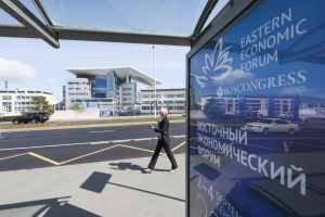
Photo: Roscongress
|
The discussion held by the Federal Service for State Registration,
Cadastre and Cartography (Rosreestr) focused on the role of spatial data
in land management - what government’s decisions on land resources are
required by the new trends, how can be land more effectively managed,
what tools and services can be used to increase the availability and
quality of real property?
|
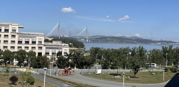
Vladivostok, Russia - Photo: Daria Svistunova
Land administration and geospatial information management
in a European context
Fredrik Zetterquist, Chair, UNECE Working Party on Land
Administration

Fredrik Zetterquist addressing online, Photo: Rosreestr
The Working Party recently launched a scenario study on future
national arrangements of land administration and geospatial information
management in the region. A survey among land administration authorities
suggests that the arrangements tend to move from the Conventional
scenario towards digitally enabled ecosystems and with more inclusion of
the private sector (figure 1).
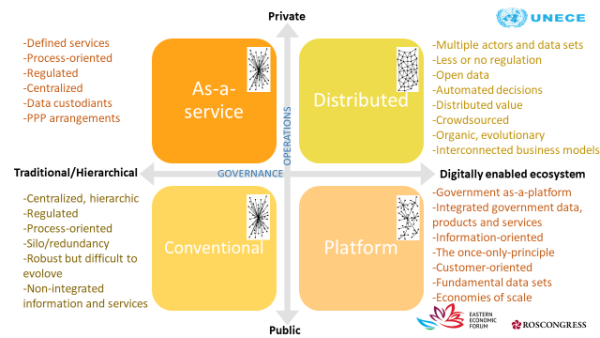
Figure 1. Four future scenarios based on global megatrends and
domain-specific drivers
The Conventional scenario is characterized by a process-oriented
hierarchical organization with the State in the driver’s seat and data
captured and updated in a controlled way, resulting in authoritative
data. Services, processes as well as conditions and performance of
professionals are strictly regulated. Often, the various data sets are
stored in several silos with a risk of work redundancy and overlap of
information. While national arrangements in this scenario often can be
considered as robust, they tend to be characterized by constraints to
evolve, develop new capabilities and meet new expectations.
In the Platform scenario, land administration and geospatial information
management is part of a federated system architecture, often referred to
as Government-as-a-platform. Typically, a range of key registers with
national data sets are included, sometimes within a government cloud.
The once-only principle is applied for data capture in order to avoid
work redundancy and data duplication and inconsistency. This arrangement
facilitates the provision of data-centric applications and has the
potential to provide economies of scale for the Government while, at the
same time, improve the sharing of integrated national data sets and
capabilities across organizations and sector boundaries.
The so-called Distributed scenario is the most visionary one. It
represents an environment with a highly automated and multi-stakeholder
arrangement, where the private sector has a large stake and where
governance is moving to an ecosystem of technologies, platforms and
diverse sets of stakeholders. The widened opportunities for the
integration of data from multiple providers, combined with an open data
policy, require a high degree of standardization and stringent policies
on compliance with data privacy and data security regulations. The
concept facilitates process automation and transparency, and enables a
wide spectra of user applications. It also provides for a built-in
evolutionary environment that, in a complex context, could transform and
adapt to new customer expectations over time. It has the potential to
trigger digital engagements and efficiently leverage digital trust.
The conducted survey indicates the position of the different national
arrangements today and the expected, as well as desired, position in
2030. A shift of the national arrangements towards a more digitally
enabled environment is expected. Even the short period prior and after
the pandemic indicate a shift of the current state.
The study will be used as a dialogue instrument to continuously refine
the scenarios and discuss appropriate actions to be made in order for
the responsible state authorities to remain relevant well into the
future.
The Role of the Geospatial Information in Responding to Crises and
Accelerating the Economic Development
Rumyana Tonchovska, UNFAO
Today’s challenges are many, complex and interlinked. To name just a
few: the global health crises; climate change and the increased
intensity and frequency of natural disasters; rapid urbanization; ever
increasing demand for natural resources; increased food, water and
energy insecurity; emerging violent conflicts; large migration, and the
list goes on.

Rumyana Tonchovska addressing online Photo:
Rosreestr
|
Most of data needed to respond to those challenges are location based
data. “Covid-19 pandemic not only created new social, economic and
health challenges, but reinforced the pre-existing obstacles, such as
lack of timely fundamental data and enabling technologies to measure and
monitor what is happening where, when, and how.” –UN-GGIM.
|
On a positive note:
- Covid-19 lead to accelerated
digital transformation and elevated digitalization to policy priority
across the board: New e-services, incl. mobile services - implemented
faster than ever; Increased used of e-services – In Croatia for
example the use of e-services for property registration went up from 5%
to above 60% during the pandemic; Governments recognised the benefits of
the Geospatial platforms and Geospatial data. In India, by liberalizing
and democratizing geospatial data early this year, a direct impact of
about $1 trillion is expected to be created by 2030.
- The 4th Industrial Revolution is
leading to an explosion in the volume of geospatially referenced data.
The evolving user demand and the dynamic business environment make it
necessary to integrate frontier technology including AI, ML, automatic
change detection, 5G, etc. with geospatial data and technology.
At the European level the EU INSPIRE Directive from 2003 makes it
mandatory for all EU MS to prepare a national legislation, to make all
34 data themes interoperable based on adoption of common International
standards and share them in a not restrictive way. Other countries from
the region are using the EU MS experience to advance the development of
their NSDIs. The process of data harmonization is going not as quickly
as expected and the EU is looking for collection of good practices and
innovations for facilitating data sharing, using AI and ML for example.
At the UN level, the First United Nations World Geospatial Information
Congress in China in 2018, substantively improved the understanding of
the role of geospatial information management, innovation and related
technologies. India is going to host the second United Nations World
Geospatial Information Congress (UNWGIC) in 2022.
UN-GGIM together with the World Bank and other partners developed the
Integrated Geospatial Information Framework an Implementing guide
covering GOVERNANCE, TECHNOLOGY and PEOPLE.
FAO together with the World Bank developed a methodology for development
of country level action plans, which includes several steps:
- Initial baseline assessment
- Geospatial alignment to the
government policy drivers
- Socio-economic and environmental
benefit analyses to help decision makers to decide on the top
priorities.
- Development of action and
investment plans with KPIs, risks, and risk mitigation measures.
In July 2021 a socio-economic benefit analyses in Serbia shows the rate
of return of investments in SDI 5:1 during the next 10 years. The
socio-economic benefits analyses Mongolia in 2020 provided a
justification for financing by the WB a new Digital Development
Project with a vision: Geo-driven eGovernment and innovation that
empowers efficient and effective use of geospatial information towards
national sustainable development and economic growth. – planned to start
in 2022.
The experience from the developed Action Plans shows that land data are
coming as a top priority data sets, no matter if government key focus is
on climate change mitigation; social and environmental protection;
health; infrastructure development; green growth or economic
development. This is not a surprise as out of the 14 Fundamental Data
Themes, identified by the UN-GGIM as critical for every nation to
survive, about 11 are maintained by the Cadastre and mapping
authorities.
The FAO currently is supporting the implementation of a large scale land
governance and SDI projects, funded by the World Bank with a total
amount of above 2+ billion USD. All those projects contribute to the
NSDI. For example in Viet Nam, we are supporting the establishment of
land database and a multi-purpose land administration system, which is
part of the NSDI and a wider e-Government program.
Geospatial Information Management for Land administration, the European
Way
Hartmut Müller, Chair, FIG Commission 3 Spatial Information Management

Hartmut Müller addressing online Photo: Roscongress
Place matters. Observing and communicating the role of geospatial data
in land administration and management, tools and services provided by
the underlying technologies of spatial information management, all this
is part of the mission of the International Association of Surveyors
(FIG). The following discuss some experiences from a specifically
European and German perspective.
The European level. In the European Community the so-called INSPIRE
directive is in place, where INSPIRE is an acronym of Infrastructure for
Spatial Information. The directive came into force back in 2007. INSPIRE
is based on the geospatial data infrastructures of all Member States of
the European Union. The Directive addresses 34 spatial data themes and
is, thus, a comprehensive use case of an integrated interoperable
Spatial Information System for the heterogeneous region of the European
Community. INSPIRE builds strictly on international standards, World
Wide Web (WWW), Open Geospatial Consortium (OGC), International
Standardization Organization (ISO). The pluralism in national solutions
was integrated at the European level into a data platform based on the
input from individual member states and their systems. Implementation is
not an easy task, but the concept is of very high value.
Numerous tools have been developed to support implementation of this
cross border geospatial information infrastructure. Sets of
implementation rules, clearly defined process steps for the entire data
specification cycle, code lists, and so forth are publicly available.
With these tools, INSPIRE supports conceptually its own extension while
preserving the conformance of the framework. Parts of the overall
approach could possibly be used and adapted to create a universal
spatial data system for other world regions such as the large Far East
countries.
Two of the 34 INSPIRE themes could be of particular interest to start
with. One is the Cadastral Parcel theme, where spatial objects are
defined as areas in cadastral registers, and the other is the Land Use
theme, that is itself split in two different types, the Existing Land
Use and the Planned Land Use. A List of land use categories is available
in INSPIRE, agreed at the European level, called Hierarchical INSPIRE
Land Use Classification System (HILUCS). The elements of the list,
starting with primary production and not ending with cultural
entertainment, cover almost 100 land use classes and should be both
applicable to existing land use and planned land use. Up to date and
accurate geospatial information can support the adequate use of land in
economic and other activities by appropriate service delivery via
Internet.
The German national level. Germany, one of the founding members of the
European Community, has established its own National Spatial Data
Infrastructure more or less simultaneously with the European
developments. The goal was and is to serve the specific needs of the
German society while maintaining compatibility with the European
framework. One example is the documentation of land property in the
German cadastral system. The European system INSPIRE focuses on the
geometrical aspects of land but does not address ownership and rights
related to the parcels. In the German national system there is a close
link between the geometric shape and the ownership of land. In addition,
data on purchase prices of land in Germany are publicly available.
Under
the German Building code all real estate transactions must be notorized,
and information from the notarized deeds must be provided to public
agencies. Purchase price data is regularly compiled by responsible
appraisal committees. Reports and detailed maps for standard land values
are available, which is a potential resource for a unified information
system on land and property. Harmonization of data bases held by various
public agencies and banks is still a wish, but the technical tools are
available. Progress is still needed towards the integration of the
information into the overarching common German National Strategy for
Geoinformation.
In conclusion, Europe and Germany are on their way to providing
interoperable digital geospatial information for many themes, including
but not limited to land and real estate, but have not yet reached the
end of this journey.
National Spatial Data System in the Russian Federation
Oleg Skufinskiy, Head of Rosreestr

Oleg Skufinskiy (in the middle) Photo: Rosreestr
|
Global trends in spatial development indicate the growing role of large
urban agglomerations. Agglomerations today concentrate the main
potential of the country's economic growth, and are large labor and real
property markets, centers of production and consumption. Russia is no
exception in this regard.
The steady growth in the proportion of urban residents and the
development of new lands require new approaches to land management.
|
Rosreestr is faced with the ambitious task of consolidating spatial
data, which is aimed at increasing the efficiency of land use and
involving land in turnover, accelerating procedures in the field of land
management, appraisal, provision and registration of land plots, and
much more.
Currently, Russia has approved the state program "National Spatial Data
System", which should become a development tool, increase the
capitalization of the country's territory and improve the quality of
real property transactions. The state program involves the creation of a
unified geospatial data platform that will serve as a digital basis for
all future transformations and modernization of the industry.
The first step towards a unified spatial data system has already been
taken - in 2021, we implemented a pilot project to create a Unified
Information Resource on Land and Real Estate. In addition to Rosreestr,
10 more government agencies are involved in the experiment. Within the
framework of the project, 21 information systems are being integrated,
86 information layers are being formed with data on land and real
property, new digital services are being developed in the interests of
people: "Land Simple", "Land for construction", "Analysis of the state
and use of land", analytical service based on pre-trained neural
networks and spatial analysis algorithms "Smart Cadastre", 3D terrain
models, geocoding of address register objects and a service for
assessing the economic potential of a territory.
This will provide citizens, the state and business with access to the
most complete information about each specific land plot, including
information on the construction of housing and the provision of land
plots, as well as involve unused land into economic turnover.
Rosreestr has extensive experience in the technological support of
information systems containing spatial data.
Since 2016, the agency has been maintaining the information system of
the “Far Eastern Hectare” program, which allows interested citizens to
obtain land in the Far East for free in order to develop territories and
foster entrepreneurship. The system ensures electronic exchange of
documents between citizens and authorities.
The system is integrated with the Public Cadastral Map of Rosreestr,
which allows quick recording of up-to-date information about lands.
Conclusion: Rosreestr is changing and becoming a service provider and a
source of complete, reliable and relevant spatial data for citizens,
business and professional communities, government bodies, a center of
competence for land and real property. Our key principles are customer
focus, ecosystem approach, technological effectiveness and velocity.
Louise Friis-Hansen
28 December 2021