Article of the Month -
March 2010
|
Rapid Urbanization and Mega Cities: The
Need for
Spatial Information Management
Chryssy POTSIOU, Greece (edit.), Yerach DOYTSHER, Israel, Paul
KELLY, Australia, Rafic KHOURI, France, Robin McLAREN, United Kingdom
and Hartmut MUELLER, Germany
 This article in .pdf-format
(25 pages and 2.88 MB)
This article in .pdf-format
(25 pages and 2.88 MB)
1) This paper has been prepared for XXIV FIG
International Congress in Sydney, Australia, 11-16 April, 2010 and will
be presented in the Commission 3 Key Note Session: SIM in Support of
Mega City Management. The paper gives an introduction to FIG publication
no. 48 – “Rapid Urbanization and Mega Cities: The Need for Spatial
Information Management” that will be launched in Sydney.
SUMMARY
This paper briefly presents the resolutions of a research made within
FIG Commission 3 on the topic. The extended research study is published
in FIG publication 48. The goal of this research is to investigate the
emerging needs, the current trends and the extent of using SDIs in
selected megacities, but also to identify the emerging possibilities for
using new technical tools for the governance of sustainable large urban
areas applied by the surveying- mapping- data processing community. The
methodology followed included experience gained through the general
current FIG Com 3 activity to improve management of expanding urban
areas, review of existing publications and other sources, Internet
research on specific problems of megacities and on existing SDIs, on
site visits to a selected number of megacities and interviews with
individual decision makers in city administrations, and review and
assessment of data received from questionnaires.
1. INTRODUCTION
Today there is an ever-increasing demand for the collection,
integration, management and sharing of reliable spatial information, and
the relevant education, experience sharing and development of best
practices. This growing demand is driven by some of the most important
changes in society which in turn are magnified by rapid urbanisation and
the conditions of the world’s megacities. It is the purpose of FIG and
its Commission 3 (Spatial Information Management) to assist the
profession in all aspects of spatial data management in respond to these
challenges and in support of society everywhere.
During the 2007–2010 term of office FIG Commission 3 has addressed
the phenomenon of rapid urbanization and its impacts. Its particular
focus has been on identifying spatial tools and general principles,
norms and standards for good governance using reliable and accessible
spatial information and providing guidance to interested countries to
successfully address the problem of rapid urbanization. A central theme
has been the formal access to land, property and housing for all.
Further research will focus on climate change and disaster prevention
and response, and other security issues that emerge due to rapid
urbanization and accelerated development.
FIG Commission 3 has cooperated closely with agencies of the United
Nations (UN-ECE, WPLA, UN-HABITAT and GLTN), the World Bank, ISPRS and
other sister associations.
FIG publication 48 is a further contribution of FIG and FIG Commission 3
in this field. This paper briefly presents the recommendations presented
in this publication, which should help governments, decision makers and
professionals to deal with the major challenges of rapid urbanisation.
2. BACKGROUND TO STUDY
The International Federation of Surveyors (FIG) is an international,
non-government organisation whose purpose is to support international
collaboration for the progress of surveying in all fields and
applications. FIG Commission 3 (Spatial Information Management) has
undertaken a research study about trends in the use of spatial
information and technology in supporting the management of eight of the
world’s largest cities. The research has included:
- Management of spatial information about land, property and
marine data;
- Spatial Data Infrastructure, including policy, institutional and
technical frameworks;
- Management and transfer of knowledge and skills in using spatial
information;
- Impacts on organisational structure, business models and
public-private partnerships
- Spatial information management in the support of good city
governance.
This current research study is responsive to the aims of the
Commission 3 work plan and is a further contribution in this direction.
It investigates the current trends in using spatial information in
particular for the management of megacities, where needs are enlarged
and urgent.
Location, in the form of spatial data, is a key enabler to visualise
current situations, predict impacts and enhance service delivery.
Information about location is a natural integrator, capable of enabling
complex analysis of spatial distribution of places, events and services;
providing opportunities to link up government services, interact with
customers and optimise delivery options.
The value of spatial (location-referenced) data is growing in
recognition internationally. Many countries with developed economies now
have policies and strategies aimed at maximising the benefit from
spatial data held by government agencies in particular. A wealth of
existing map, image and measurement data can already be found in areas
such as land administration, natural resource management, marine
administration, transportation, defence, communications, utility
services and statistical collections. The challenge is for users, both
within and outside these areas of activity, to discover, access, and use
this information to improve decision-making, business outcomes and
customer services.
As cities get larger spatial information is becoming a key resource
in efficient delivery of e-government services, public safety, national
security and asset management. In this study, it is proposed that a
city-wide spatial data infrastructure linked to similar structures in
other levels of government, can provide a sustainable solution to many
problems of megacities. Despite all the progress made in spatial data
collection, modelling and dissemination, it is important to look for
ways and methods to improve e-government taking into account the needs
of citizens.
The goal of this research is to investigate the emerging needs, the
current trends and the extent of using SDIs in selected megacities, but
also to identify the emerging possibilities for using new technical
tools for the governance of sustainable large urban areas applied by the
surveying- mapping- data processing community. The study aims to
demonstrate these technical tools, not only to governmental policy
makers, but also to planners, economists, scientists, environmentalists,
sociologists and all others with an interest in the life of megacities.
However, it should be mentioned that each city should build its own
spatial data infrastructure, and should choose its own tools appropriate
to its own social, economic and cultural environment. The publication
suggests alternative ways to meet the current requirements and makes
general recommendations on best practice. It does not advocate the use
of any specific tools because each country has a different history and
experience.
The methodology followed for this study includes:
- Identification of experience gained through the general current
FIG Com 3 activity to improve management of expanding urban areas.
- Review of existing publications and other sources.
- Internet research on specific problems of megacities and on
existing SDIs.
- On site visits to a selected number of megacities and interviews
with individual decision makers in city administrations.
- Review and assessment of data received from questionnaires.
3. URBANISATION
Urbanisation is a major change taking
place globally. The urban global tipping point was reached in 2007 when
for the first time in history over half of the world’s population 3.3
billion people were living in urban areas (Figure 1). It is estimated
that a further 500 million people will be urbanised in the next five
years and projections indicate that 60% of the world’s population will
be urbanised by 2030.
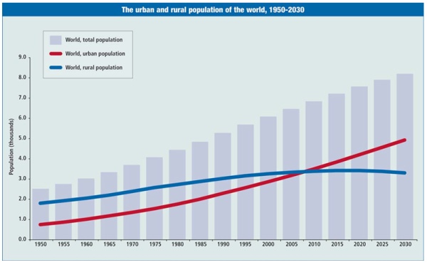
Figure 1. The urban and rural population of the world (source: UN
Population Division)
This rush to the cities, caused in part by the attraction of
opportunities for wealth generation and economic development, has
created the phenomenon of ’megacities’: urban areas with a population of
10 million or more. There are currently 19 megacities in the world and
there are expected to be 27 by 2020 (Figure 2). Over half of this growth
will be in Asia where the world’s economic geography is now shifting.
This incredibly rapid growth of megacities causes severe ecological,
economical and social problems. It is increasingly difficult to manage
this growth in a sustainable way. It is recognised that over 70% of the
growth currently takes place outside the formal planning process and
that 30% of urban populations in developing countries are living in
slums or informal settlements, i.e. where vacant state-owned or private
land is occupied illegally and is used for illegal slum housing. In
sub-Saharan Africa, 90% of new urban settlements are taking the form of
slums. These are especially vulnerable to climate change impacts as they
are usually built on hazardous sites in high-risk locations. Even in
developed countries unplanned or informal urban development is a major
issue.
Urbanisation is also contributing significantly to climate change.
The 20 largest cities consume 80% of the world’s energy and urban areas
generate 80% of greenhouse gas emissions worldwide (Figure 3). Cities
are where climate change measures will either succeed or fail.
Rapid urbanisation is presenting the greatest test for land
professionals in the application of land governance to support and
achieve the Millennium Development Goals (MDGs). The challenge is to
deal with the social, economic and environment consequences of this
development through more effective and comprehensive land administration
functions, supported by effective Spatial Data Infrastructures,
resolving issues such as climate change, insecurity, energy scarcity,
environmental pollution, infrastructure chaos and extreme poverty.
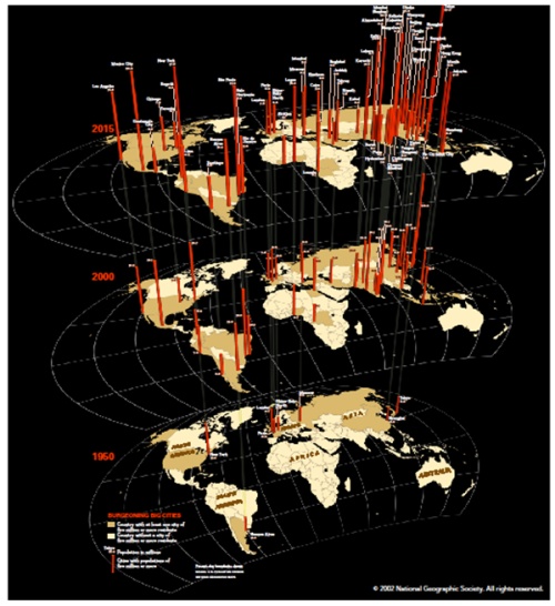
Figure 2. Growth of megacities and prediction for 2015 (source:
National Geographics)

Figure 3. Increase of greenhouse gas emissions (source: Wilbanks et
al, 2007)
4. PROBLEMS TO BE MANAGED WITHIN MEGACITIES
Administrations in large cities are often confronted with a multitude
of key problems, like high urban densities, transport, traffic
congestion, energy inadequacy, unplanned development and lack of basic
services, illegal construction both within the city and in the
periphery, informal real estate markets, creation of slums, poor natural
hazards management in overpopulated areas, crime, water, soil and air
pollution leading to environmental degradation, climate change and poor
governance arrangements (Figures 4, 5).
The inevitability of further population growth is a common issue.
Some cities reported that their administrations have little control over
population growth; it was a regional or national issue and must be
addressed at that level. However, monitoring population change
effectively and being able to respond through planning and
infrastructure development will be major challenges.
Informal settlements are a problem in many cities. An increasing
number of citizens do not have either permanent or temporary access to
land and adequate shelter. This exclusion is caused, in many cases, by
structural social inequalities, inheritance constraints, conflicts, non
pro-poor or pro-gender land policies and land administration systems
that are ineffective and expensive for the end user. Without a range of
appropriate interventions being applied within the broader context of
economic growth and poverty reduction policies, social exclusion and
poverty will continue to spiral out of control; already 90% of new
settlements in sub-Sahara Africa are slums.
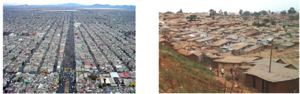
Figure 4. Informal settlements. Slum in Mexico City (left) (source:
Valenzuela),
Kibera, Kenya (right) (source:
http://www.mojamoja.org/kibera.htm)
Natural hazards and emergency management are major
issues in most cities. Risk profiles from floods, fires, earthquakes and
other hazards differ among cities, but capacity to plan, prepare,
respond and recover from disasters is a common need.
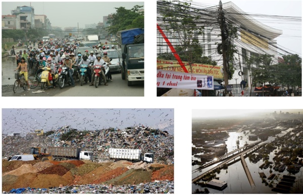
Figure 5. Examples of problems in large cities: traffic congestion,
energy inadequacy (top);
Garbage management (bottom left); floods (bottom right)
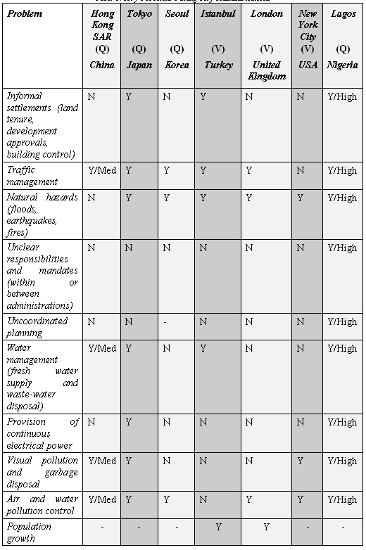
During 2007–8 for the purposes of this research study, initial data
about problems facing city administrators were obtained from seven
cities (Hong Kong, Tokyo, Seoul, Istanbul, London, New York and Lagos)
either by their direct response to the questionnaire (Q) or by personal
visits (V) and interviews by the authors and contributors. Table 1 shows
the information derived from that stage of research.
Table 1: Key Problems Facing City Administrations
5. CITY GOVERNANCE
Many cities appear to have problems with unclear and overlapping
responsibilities amongst internal and external agencies, leading to
operational dysfunction such as a multitude of agencies holding
non-accessible spatial information. For example, Sao Paulo comprises
component cities all with their own governance arrangements. It is clear
that solutions to problems facing megacities require concerted response
from many internal units and regional and national agencies in areas
such as planning, infrastructure, development and land use controls,
transportation, environmental management and water management. Mandates
might be clear, but rationalisation of functions and more effective
levels of cooperation and information sharing are needed.
Even if city planning is centrally coordinated, city administrations
often have little control over the implementation (i.e. land use and
building controls) of their policies and plans. For example, in France
the greater Paris region, Île de France, has a regional planning
authority that sets planning policies for the highly decentralised 1,280
communes (fig.6). Political differences create tensions in the
consistent implementation of these planning policies.
The influence of megacities reaches well outside their administrative
boundaries to the peri-urban and regions beyond. It is essential that
the greater region be managed holistically to maximise the economic
benefits of the city. Regional planning places even greater emphasis on
effective governance of the larger region, even across international
boundaries, with cooperation in planning, development control and
sharing information being essential.
In many cases, infrastructure providers are not a direct part of the
city administration’s planning and development process, some are private
enterprises while others may be located at another level of government.
This causes problems with the proactive planning and strengthening of
utility services.
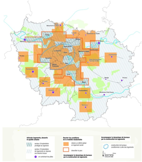
Figure 6. The greater Paris master plan project-housing (source:
SDRIF, 2008)
Most megacities support some level of civil society participation in
the planning and design of their services, such as citizen involvement
in the urban planning process. However, spatially enabled web based
services are providing new opportunities to more closely involve
citizens in consultations and land administration functions.
6. SPATIAL INFORMATION TO MANAGE MEGACITIES
The rapid growth of megacities causes severe social, economical and
ecological problems. How can this growth be nurtured in a sustainable
way? The challenge for land professionals is to provide the megacity
‘managers’, both political and professional, with appropriate
‘actionable intelligence’ that is up-to-date, citywide and in a timely
manner to support more proactive decision making that encourages more
effective sustainable development.
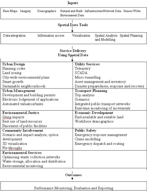
Spatial information has become indispensable for numerous aspects of
urban development, planning and management. The increasing importance of
spatial information has been due to recent strides in spatial
information capture (especially satellite remote sensing and
positioning), management (utilising geographic information systems and
database tools) and access (witness the growth in web mapping services),
as well as the development of analytical techniques such as high
resolution mapping of urban environments (Table 2). These more efficient
techniques can lead to a wider diversity of information that is more
up-to-date.
In some circumstances, a wealth of existing map, image and
measurement data can already be found in areas such as land
administration, natural resource management, marine administration,
transportation, defence, communications, utility services and
statistical collections. The challenge is for users both within and
outside these areas of activity to break down the information silos and
to discover, to access and to use the shared information to improve
decision-making, business outcomes and customer services.
The study has found that spatial information technology is being
recognised widely as one of the tools needed to understand and address
the big urban problems, but there is still a general lack of knowledge
amongst communities of practice about what spatial solutions exist and
how they can used and prioritised.
Information to support the management of cities is traditionally
channelled and aggregated up the vertical information highway from a
local, operational level to a policy level. In developed countries,
urban growth and its characteristics can normally be measured through
information derived from the land administration functions. However, in
the megacities of the developing countries, informal settlements are the
norm, growth is rampant and administrative structures are limited. The
traditional source of change information is not readily available there.
Table 2: Use of Spatial Data in
City Administration (source: Spatial Strategies Pty Ltd Australia)
Inputs
7. SPATIAL DATA INFRASTRUCTURES (SDI) FOR MEGACITIES
The concept of using SDI to more efficiently manage, access and use
spatial information across megacities is evolving and megacities are at
different stages of their implementation. The EC INSPIRE Directive has
provided welcome impetus across Europe and beyond. However, most cities
have no strategic framework to guide and create their SDI. This reflects
the difficulty of the task to create an SDI within megacities that are
organisationally complex and involve a large number of stakeholders with
diverse sets of spatial information; a microcosm of the national
problem.
City administrations have different interpretations of what
constitutes an SDI, but most reported that they had at least some
elements of an SDI already in place. Cities like Paris and New York have
a more mature and comprehensive implementation of a megacity SDI,
managed by dedicated resources. However, most cities reported that they
had only small “central GIS units”, under-resourced and generally
incapable of providing a comprehensive citywide SDI. Missing
capabilities included no spatial data policies and standards, common
metadata, formal data sharing arrangements between units or agencies, or
shared data access mechanisms. It could be many years before mature and
fully populated SDI emerge in megacities. However, it is important for
megacities, especially in developing countries, to develop SDI
capabilities in areas that will deliver the most benefits to their
current pressing needs.
Most do not have a formal “spatial information strategy” across the
whole administration. However, most countries covered by this project
have national (and in some cases regional) SDI strategies. At this stage
it is not clear what connection there is between national and local
strategies or how national strategies will meet the needs of cities.
Some cities, for example New York, have developed an intranet that
could be used to access spatial data held across multiple units. Other
cities, such as Buenos Aires (Figure 7), have invested in providing
access to spatial data as part of their public websites, reporting
information about aspects of city administration such as land tenure,
use, planning, environmental and disaster management information.
Approaches like these should be used as exemplars by other cities.
Although Norway does not have megacities, the Norwegian SDI provides
a model for an application of spatial data infrastructure in a
democratic society enabling citizen participation in policy and
decision-making for city management (Figure 8).
Table 3: Application of SDI in the
world’s megacities (source: Boos and Mueller, 2009)
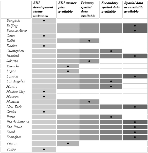
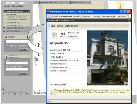
Figure 7: Public access to parcel information of the City of Buenos
Aires, Argentina
(source:
http://mapa.buenosaires.gov.ar/sig/index.phtml)

Figure 8: Citizen Services on Norwegian MyPage Geoportal (source:
Strande, 2009)
8. INNOVATIVE USES OF SPATIAL INFORMATION TOOLS TO MANAGE
MEGACITIES
New tools, techniques and policies are required to baseline and
integrate the social, economic and environmental factors associated with
megacities, to monitor growth and change across the megacity and to
forecast areas of risk – all within shorter timeframes than previously
accepted. Moreover, they must be flexible enough to meet traditional
needs such as land development, tenure and value applications, but be
designed to be interoperable and integrate within the city wide SDI as
it evolves. Access to integrated spatial information from the SDI will
lead to more joined-up, proactive decision making allowing the
prioritising of scarce resources to tackle the most sensitive and risk
prone areas within a megacity.
These tools must support the operation of land administration
functions, but should also support the management of key problems such
as disaster management, flooding control, environmental management,
health and transportation, for example, but also encourage economic
development and reduce social inequalities.
These spatial information tools include:
- Data collection (Figure 9) & maintenance – high resolution
satellite imagery (< 0.5m) is now commercially available at an
affordable rate from a number of sources with repeat coverage at a
frequency greater than required for this application. This opens up
the possibility to efficiently generate topographic and thematic
mapping (at a scale of at least 1:5,000) and to better understand
changes across the city, such as sporadic creation of informal
settlements (Figure 10, 11).
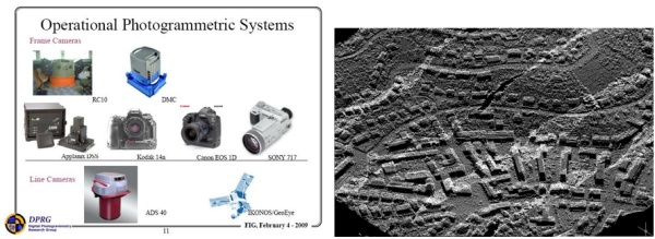
Figure 9. Operational Photogrammetric Systems (left) (source: Habib,
2009);
Sample of LiDAR data – a 3D view of urban neighborhood (right)
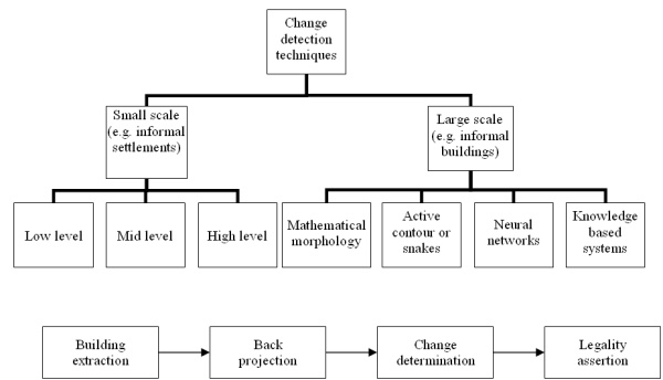
Figure 10. Change detection techniques categorized by scale (top);
Phases of informal building monitoring (bottom) (source: Ioannidis et
al, 2009)
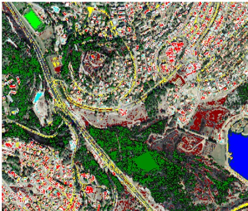
Figure 11: Change detection results – a comparison of satellite
imagery and aerial photograph (source: Beit-Yaakov, 2003)
- Data integration and access – international interoperable
information and services standards allow the possibility of the
real-time merging of data and services (plug and play) from a
variety of sources across the city. This will be achieved through
the creation of shared, web information services to allow users
access to the wide range of information held by different agencies
across the city. This will be instrumental in breaking down
information silos and will lead to the innovative re-use of spatial
information.
- Data analysis - data mining and knowledge discovery techniques
allow the integration of a wide range of spatial information and
associated attribute information. This creates the opportunity to
perform more effective forms of analysis and decision-making,
leading to more cost effective solutions such as targeting of
limited city resources for health care and maximising the economic
benefits of investments in transportation.
- 3-D city modelling (Figures 12, 13, 14) - many applications are
enhanced by the use of 3-D spatial information, such as
visualisation of planning development proposals, flood predictions,
modelling population growth, tourist visit simulations and the
design of transportation networks. 3-D spatial information of the
natural and built environments is increasingly available, e.g.
through LiDAR and terrestrial laser scanning, making many of these
applications operationally viable.
- Citizen centric urban sensing – The new generation of urban
sensors, including cellular phones (Figure 15), has potential for
providing managers with access to a range of current spatial and
environmental information about the evolving activities of their
megacities. By these means peoples’ movements can be monitored;
their use and modes of transport determined and people could
voluntarily provide information about changes to their environment.
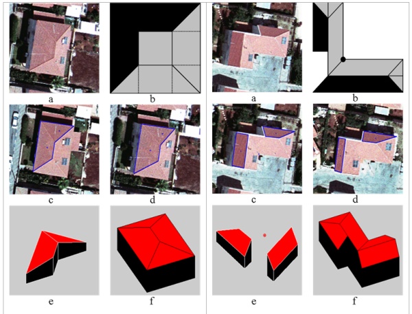
Figure 12: Steps in automatic extraction process of 3D building from
aerial photographs
(G-Model roof – left; L-Model roof – right) (source: Avrahami et al.,
2008)
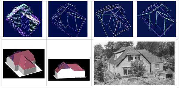
Figure 13: Steps in automatic extraction process of 3D building from
LiDAR data –segmentation 4 segments
handling 4 topological analysis
4 line and vertices extraction (top from
left to right); the extracted 3D building and results verification
(source: Abo Akel et al., 2006)
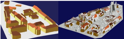
Figure 14: A 3D view of an urban neighborhood showing the original
LiDAR data (right) and the complete reconstruction results (left)
(source: Abo Akel et al., 2006)
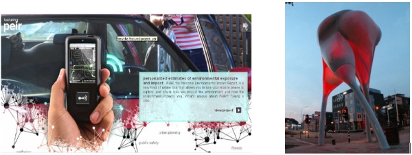
Figure 15: Personalized estimates of environmental exposure (source:
http://urban.cens.ucla.edu/) (left);
Interactive D-Tower in the Netherlands (Photo: Henk Vlasblom) (right)
However a number of prerequisites are indicated:
- Legislative and policy frameworks;
- A system of quality analysis of information and data voluntarily
submitted from unofficial sources.
- Agreement on what information can be captured and how it can be
used. Citizens can choose to opt out; to volunteer information; or
to participate in incentive schemes;
- Appeals for crowdsourcing should focused on topics to help
manage the city more effectively, e.g. environmental damage;
- An information infrastructure to manage, analyse and distribute
urban sensed information to facilitate its widespread use in solving
urban problems; and
- A communication strategy to provide transparency and to ensure
that citizens understand the benefits.
It is probable that people will participate when provided with smooth
and ubiquitous access to information and the ease of providing
information through m-government applications, for example. The
increased levels and quality of participation will most likely take time
to evolve as citizens gradually realise tangible evidence of urban
improvements related to their participation. One initial consequence may
be that city authorities just receive hundreds of trivial requests for
services. This traffic must be managed effectively and acted upon in a
beneficial manner by city authorities to build trust with the citizens.
The successful introduction of urban sensing will involve
considerable cultural and behavioural change of politicians, government
officials, the business community and citizens and develop incrementally
as policies and legislation evolve. It has great potential to fill the
current gaps in urban information needed to understand the dynamics of
megacities.
At the national level, no country has so far generated data management
policies that truly integrate and utilise this new approach. In
Doetinchem in the Netherlands, a 12 metre tall tower (Figure 13 right)
maps emotions of the inhabitants. The tower changes the lights according
to emotions reflected from the D-tower website (www.d-toren.nl).
Devices as citizen-activated sensors, RFID and LBS may provide
government with efficient and practical means of data collection in
support of urban management and environmental monitoring. However, these
devices are also potential tools for citizen control by totalitarian
governments. What may begin as traffic control may be adapted to crowd
and demonstration control. The D-Tower of the Netherlands could easily
become a device designed to give a repressive government of some other
country a means of early detection and suppression of popular dissent.
All such “urban sensing” devices must be subject to full public
awareness and acceptance. There must be an enactment of enabling
legislation. Due process must be available to the citizenry of any
democracy, including judicial challenge and final adjudication.
As these devices are currently in experimental stages primarily in
countries with developed economies and long established democratic
processes, there may be concerns that there would be a major risk in
introducing such systems in unstable governments in developing
economies. Citizen participation in data collection must be
voluntary and data collection methods must be transparent and open to
public understanding.
9. SPATIAL INFORMATION POLICY CONSTRAINTS
Advances in developing megacity SDI will only occur when senior
management are convinced of the benefits through experience derived from
business case studies and only when SDI implementation is guided by a
supportive megacity information strategy. However, it is difficult to
achieve this type of strategy in the complex multi-layer governance
structures of the megacities.
As spatial information is used more commonly with more citizen
awareness, there is a risk of popular mistrust concerning privacy
issues. It is therefore essential that policy frameworks are established
legally for the appropriate use of spatial information. It is also
important to raise public awareness about the benefits citizens will
enjoy through SDI, mainly due to increased transparency in city
governance; and the opportunity for public participation in
decision-making.
It must be recognised that citizen participation in information
gathering suggests certain risks like the concern for privacy;
suspicion of governmental intrusion and loss of public support; the
issue of quality of data collected by non professionals and the need for
quality analysis; the danger of miss-use of citizen-provided information
by repressive governments; and the question of the capacity of
governmental agencies to monitor, evaluate, and interpret the volumes of
data collected in certain urban sensing systems.
ACKNOWLEDGEMENTS
Special thanks go to the correspondents in the seven megacities used
as case studies, to Prof Rahmi Nurhan CELIK, Istanbul Technical
University and Anthony ADEOYE, Lagos city administrator. To Gerasimos
APOSTOLATOS, FIG Com3 vice chair of Administration and all FIG
Commission 3 delegates who have participated and prepared coordinated
research papers in the three annual workshops is gratefully
acknowledged. To the Technical Chamber of Greece for its continous
four-year support of FIG Commission 3 relevant activities and for
hosting the annual 2007 Comission 3 Workshop; to the Spanish Association
of Surveyors and to DVW German Association of ¬Geodesy, Geoinformation
and Land Management for hosting the annual Commission 3 workshops; and
to the French Order of Surveyors for hosting the final expert group
meeting in Paris.
Special thanks to Prof Stig ENEMARK, President of FIG, for providing
strategic guidance in identifying urbanisation as a key global issue in
supporting the Millennium Development Goals.
REFERENCES
- Abo Akel N., Filin S., Doytsher Y., 2009. "Reconstruction of
Complex Shape Buildings from LiDAR Data Using Free Form Surfaces".
Photogrammetric Engineering and Remote Sensing, 75(3):271-280.
- Albrecht K. 2008. "RFID Tag – You’re It". Scientific American,
299(3): 48-53.
- Albrecht K., McIntyre L., 2006. "Spychips: How Major
Corporations and Governments Plan to Track Your Every Move".
Published by Plume (Penguin), Oct. 2006, ISBN 0452287669.
Altan O., 2009. "Role of Geospatial Professionals in Risk and
Disaster Management and Preventing Natural Catastrophies".
Proceedings of the FIG Working Week 2009, Eilat, Israel,
http://www.ortra.com/fig/
- Avrahami Y., Raizman Y., Doytsher Y., 2008. "A Polygonal
Approach for Automation in Extraction of Serial Modular Roofs",
Photogrammetric Engineering and Remote Sensing, 74(11):1365-1378.
Baltsavias E.P., 2004. "Object Extraction and Revision by Image
Analysis Using Existing Geodata and Knowledge: Current Status and
Steps towards Operational Systems". ISPRS Journal of Photogrammetry
& Remote Sensing, 58(3-4):129-151.
- Boos S, Müller H., 2009. "SDI Developments in the World’s
Currently Existing Mega Cities".
http://www.fig.net/pub/monthly_articles/april_2009/april_2009_boos_mueller.html,
FIG Article of the Month, April 2009.
- Clinton W., 1994. "Coordinating Geographic Data Acquisition and
Access: The National Spatial Data Infrastructure", Executive Order
12906, April 13, 1994, Federal Register, 59 (71): 17671-17674.
- Cuff D., Hansen M., King J., 2008. "Urban Sensing: Out of the
Woods". Communications of the ACM, 51(3): 24-33.
- Doytsher Y., Dalyot S., 2009. "Producing Seamless Multi-Source
Quality-Dependent Digital Terrain Models". Proceedings of the 7th
FIG Regional Conference, Hanoi, Vietnam,
http://www.fig.net/pub/vietnam/papers/ts02e/ts02e_doytsher_dalyot_3590.pdf
- Doytsher Y., Dalyot S., Katzil Y., 2009. "Digital Terrain
Models: a Tool for Establishing Reliable and Qualitative
Environmental Control Processes". GeoSpatial Visual Analytics:
Geographical Information Processing and Visual Analytics for
Environmental Security, Raffaele De Amicis, Radovan Stojanovic,
Giuseppe Conti (Eds.), Springer Science and Business Media, pp.
215-234, ISBN 978-90-481-2897-6
- Enemark S., 2007. "Integrated Land-Use Management for
Sustainable Development". Proceedings of the Joint FIG Commission 3,
UN/ECE Working Party on Land Administration and UN/ECE Committee on
Housing and Land Management Workshop, Sounio, Greece.
Enemark S., 2009. "Facing the Global Agenda-Focus on Land
Governance". Proceedings of the FIG Working Week 2009, Eilat,
Israel,
http://www.ortra.com/fig/
- Enemark S., McLaren R., 2008. "Preventing Informal Development -
through Means of Sustainable Land Use Control". Proceedings of the
FIG Working Week, Stockholm,
http://www.fig.net/pub/fig2008/papers/ts08a/ts08a_01_enemark_mclaren_2734.pdf
European Union, 2007. "Directive 2007/2/EC of the European
Parliament and of the Council of 14 March 2007 Establishing an
Infrastructure for Spatial Information in the European Community
(INSPIRE)". Official Journal of the European Union, L108:1-14.
- Habib A., 2009. "Integration of Photogrammetric and LIDAR Data
for Accurate Reconstruction/Visualization of Urban Environments".
Proceedings of the FIG Com3 Workshop on Spatial Information for
Sustainable Management of Urban Areas, Mainz, Germany.
Hofmann P., Strobl J., Blaschke T., Kux H., 2006. "Detecting
Informal Settlements from Quickbird Data in Rio De Janeiro Using an
Object Based Approach". International Archives of the
Photogrammetry, Remote Sensing and Spatial Information Sciences,
Salzburg, Austria, XXXVI(4/C42), unpaginated CD-ROM.
- Hurskainen P., Pellikka P., 2004. "Change Detection of Informal
Settlements Using Multi-Temporal Aerial Photographs - The Case of
Voi, SE-Kenya", Proceedings of the 5th African Association of Remote
Sensing of the Environment conference, Nairobi, Kenya, unpaginated
CD-ROM.
- Ioannidis C., Psaltis C., Potsiou C., 2009. ”Towards a strategy
for control of suburban informal building through automatic change
detection”. Journal of Computers, Environment and Urban Systems
(CEUS), 33(1): 64-74.
- Kelly P., 2007. “Role of Spatial Data Infrastructures in
Managing Our Cities”. Proceedings of the FIG Commission 3 Annual
Meeting, Sounion, Greece.
- Kelly P., 2008. "Commission 3 at the 9th Congress of
Metropolis". URL:
http://www.fig.net/news/news_2008/ sydney_oct_2008.htm
- Kelly P., 2008. "Current Problems and Issues in Using SDI in
Mega cities", Report of FIG Working Group 3.2: Spatial Data
Infrastructures in Megacities, unpublished.
- Kötter T. 2004. "Risks and Opportunities of Urbanisation and
Megacities". Proceedings of the FIG Working Week, Athens, Greece,
http://www.fig.net/pub/athens/papers/ps02/ps02_2_kotter.pdf
- Lavedan P., 1926. "Histoire de l’ Architecture Urbaine", t.1, H.
Laurence, Paris.
- Leobet M., 2009. "Implementing INSPIRE in Real Life: the French
Case", Spatial Informational Council Meeting, GSDI, June 2009,
CNIG/LBT
- Leading Edge Forum 2008, 2008. "Digital Disruptions, Technology
Innovations Powering the 21st Century Business”, URL:
http://www.csc.com/features/stories
- McLaren R., Mahoney R., 2000. "NSDI in the UK - Quo Vadis".
Proceedings of the FIG Working Week 2000, Prague, Czech Republic
http://www.fig.net/pub/proceedings/prague-final-papers/mclaren.htm
- McLaren R.A., Coleman D., Mayunga S., 2005. "Sustainable
Management of Mega Growth in Megacities". Proceedings of the FIG
Working Week, Cairo, Egypt,
http://www.fig.net/pub/cairo/papers/ts_19/ts19_01_mclaren_etal.pdf
- Nebert D.D. (Ed.), 2004. "The SDI Cookbook – Developing Spatial
Data Infrastructures", Version 2.0, GSDI – Global Spatial Data
Infrastructure, http://gsdi.org/docs2004/ Cookbook/cookbookV2.0.pdf
- Potsiou C., 2008. "Unplanned Urban Development and the Need for
Good Spatial Information Infrastructure". Proceedings of the FIG
Commission 3 Workshop on ‘Spatial Information Management toward
Environmental Management of Mega Cities’, Valencia, Spain,
unpaginated CD-ROM..
- Potsiou C., 2009. "Tools for Legal Integration and Provision of
Environmental Improvements in Informal Settlements in Europe – A
case study from Albania and Greece". Global Land Tool Network, UN
HABITAT, (to be published).
- Potsiou C., Ioannidis C., 2006. "Informal Settlements in Greece:
The Mystery of Missing Information and the Difficulty of Their
Integration into A Legal Framework". Proceedings of the 5th FIG
Regional Conference, Accra, Ghana,
http://www.fig.net/pub/accra/papers/ts03/ts03_04_potsiou_ioannidis.pdf
- Potsiou C., Doytsher Y., 2009. “Technical Tools for
Environmental Urban Management ”, Proceedings of the 7th FIG
Regional Conference, Hanoi, Vietnam,
http://www.fig.net/pub/vietnam/papers/ts01d/ts01d_strande_3595.pdf
Ramírez J.O., 2005. "The Spatial Data Infrastructure of México
'IDEMex'". Proceedings of the FIG Working Week 2005 and GSDI-8,
Cairo, Egypt,
http://www.fig.net/pub/cairo/papers/ts_31/ts31_05_olvera.pdf
- Sester M., 2009. "The Potential of Geosensor Networks for
Sustainable Management of Urban Areas". Proceedings of the FIG Com3
Workshop on Spatial Information for Sustainable Management of Urban
Areas, Mainz, Germany.
- Steven A.R., 2005. "The US National Spatial Data Infrastructure:
What is new?", Proceedings of the ISPRS Workshop on Service and
Application of Spatial Data Infrastructure, Hangzhou, China,
XXXVI(4/W6).
- Strande K., 2009. "Spatial Data Infrastructure as Tools in
Environment and Geohazard Management Examples from Norway".
Proceedings of the 7th FIG Regional Conference, Hanoi, Vietnam,
http://www.fig.net/pub/vietnam/papers/ts01d/ts01d_strande_3595.pdf
Trimi S., Sheng H., 2008. "Emerging Trends in M-Government".
Communications of the ACM, 51(5): 53-58.
- Tsenkova S., Potsiou C., Badyina A., 2009. "Self-Made Cities –
In Search of Sustainable Solutions for Informal Settlements in the
United Nations Economic Commissions for Europe region". United
Nations Economic Commission for Europe (UNECE), United Nations
Publications, ISBN 978-92-1-117005-4, Geneva, p. 113.
UN-Habitat, 2006. "State of the World’s Cities 2006/7", UN-Habitat,
Nairobi. ISBN 92/1/131811-4,
http://www.unhabitat.org/pmss/getPage.asp?page=bookView&book=2101
- United Nations Population Division, 2006. "World Urbanisation
Prospects: The 2005 Revision", New York.
- Williamson I., Enemark S., Wallace J., Rajabifard A., 2009.
“Land Administration for Sustainable Development”. ESRI press, ISBN
9781589480414, United States, p. 512.
- Williamson I., Rajabifard A., Binns, 2006. "The Role of Spatial
Data Infrastructures in Establishing an Enabling Platform for
Decision Making in Australia". Proceedings of the GSDI-9 Conference,
Santiago, Chile.
- World Bank, 2009. "World Development Report 2009, Reshaping
Economic Geography", The International Bank for Reconstruction and
Development / The World Bank, ISBN 978-0-8213-7607-2.
- Zhao J., Coleman D.J., 2006. "GeoDF: Towards a SDI-based PPGIS
Application for E-Governance". Proceedings of the GSDI 9 Conference,
Santiago, Chile,
http://www.gsdi9.cl/english/papers/TS9.3paper.pdf
BIOGRAPHICAL NOTES
Prof Dr Yerach DOYTSHER, Dean of the Faculty of Architecture
and Town Planning, Technion Israel Institute of Technology, vice chair
of FIG Com3, Israel
Paul KELLY, Director, Spatial Strategies Pty Ltd, chair of FIG
WG 3.2, Australia
Rafic KHOURI, Senior International, Relations Officer, Ordre
Des Geometres Experts, France
Robin McLAREN, Director of Independent GIS Consulting Company
KNOW EDGE LTD, United Kingdom
Prof Dr Hartmut MUELLER, Mainz University of Applied Sciences,
co-chair of FIG WG 3.2, Germany
Dr Chryssy A POTSIOU, Lecturer at the School of Rural and
Surveying Engineering of the National Technical University of Athens,
Chair of FIG Commission 3, Greece
CONTACTS
Dr. Chryssy Potsiou
Lecturer at the School of Rural and Surveying Engineering of the
National Technical University of Athens,
Chair of FIG Commission 3,
Greece
+30 210 7722 688
chryssy.potsiou@gmail.com
 |


