Article of the Month -
April 2008
|
Using Cadastres to Support Sustainable Development
Professor Ian WILLIAMSON, Centre for Spatial Data
Infrastructures and Land Administration, The University of Melbourne,
Australia

 This article in .pdf-format (236
kB)
This article in .pdf-format (236
kB)
1) This paper was presented for the
first time at the Spanish IX National Congress of Surveying Engineers
TOP-CART 2008 in Valencia, Spain 18-21 February 2008.
ABSTRACT
An important government activity for all nation states is building
and maintaining a land administration system (LAS) with the primary
objective of supporting an efficient and effective land market. This
usually includes cadastral surveys to identify and subdivide land, land
registry systems to support simple land trading (buying, selling,
mortgaging and leasing land) and land information systems to facilitate
access to the relevant information, increasingly through an Internet
enabled e-government environment. For most countries a cadastre is at
the core of the LAS providing spatial integrity and unique land parcel
identification in support of security of tenure and effective land
trading. For many cadastral and land administration officials and for
much of society, these are the primary, and in many cases the only roles
of the cadastre and LAS. However the role, and particularly the
potential of LAS and their core cadastres, have rapidly expanded over
the last couple of decades and will continue to change in the future.
Cadastres provide the location or place for many activities in the
built environment through the cadastral map. This in turn provides the
spatial enablement of the broader land administration system. Cadastres
permit geocoding of property identifiers and particularly street
addresses that then facilitate spatially enablement government and wider
society. While the land market function of cadastres is essential, the
ability to spatially enable society is proving to be just as important
as or even more important than the land market function. In particular
spatial enablement allows governments to more easily deliver sustainable
development (economic, environmental, social and governance dimensions),
increasingly the over-arching objectives of government.
This paper describes the role that cadastres play in land
administration systems and also the provision of the spatial dimension
of the built environment in national spatial data infrastructures
(NSDI). The paper then explores how the cadastre supports spatial
enablement of government and wider society to pursue sustainable
development goals. It concludes by challenging land administration
officials to capitalize on the potential of LAS and cadastres to improve
the achievement of these goals.
ACKNOWLEDGEMENTS
This article draws on the collegiate creative efforts of colleagues
in the Centre for Spatial Data Infrastructures and Land Administration,
Department of Geomatics, University of Melbourne, Australia and
particularly joint research with Associate Professor Abbas Rajabifard
and Ms Jude Wallace. However any errors are entirely the author’s
responsibility.
1. INTRODUCTION
Land surveyors, lawyers and land administrators are experts in
designing, building and managing cadastral systems as core components of
our land administration systems (LAS). They are experienced in creating,
describing and defining land parcels and associated rights.
Historically, society required these skills to support an efficient and
effective land market in which these rights in land are traded to
promote economic development. By the mid nineteenth century, trading
involved buying, selling, mortgaging and leasing of rights in land. By
the mid twentieth century, land administration and cadastral officials,
and associated legal and surveying professionals, assumed that they
understood land markets, and that they had developed appropriate
professional skills to serve the needs of those markets.
Unfortunately these professionals were involved in supporting the
land trading activities, not designing them. Simply there is little
documentation in the literature on how to design and build a land market
or even on the development and growth of land markets (however, see
Wallace and Williamson, 2006a).
It is ironic that surveyors, for example, pride themselves on working
from the “whole to the part”, yet they gave little effort to designing
land markets, and then designing the cadastre, a LAS, and supporting
technical and administrative skills to support them. Historically, as
professionals we went the other way round: we often designed LAS and
then hoped that they would support efficient and effective land markets.
Experience around the world shows that the results in many countries are
less than satisfactory.
In general existing land administration (LA) skills are appropriate
for simple land markets which focus on traditional land development and
simple land trading; however land markets have evolved dramatically in
the last 50 years and have become very complicated, with the major
wealth creation mechanisms in the most developed countries focused on
the trading of complex commodities.
While the expansion of our LAS to support the trading of complex
commodities offers many opportunities for LA administrators, one
particular commodity - land information and particularly its spatial
dimension – has the potential to significantly change the way societies
operate, and how governments and the private sector do business.
The growth of markets in complex commodities is a logical evolution
of our people to land relationships, and our evolving cadastral and LAS.
The changing people to land relationships, the need to pursue
sustainable development and the increasing need to administer complex
commodities within an ICT (information and communications technologies)
enabled virtual world, offer new opportunities for our land
administration systems as they increasingly play a key role in spatially
enabling governments and wider society. However many challenges need to
be overcome before these opportunities can be achieved. For an overview
of trends in spatially enabling government and society see Rajabifard
(2007), PCGIAP (2007) and OSDM (2007).
Research aimed at understanding and meeting these challenges is
undertaken within the Centre for Spatial Data Infrastructures and Land
Administration, Department of Geomatics, University of Melbourne (
http://www.geom.unimelb.edu.au/research/SDI_research/ ). The over
arching focus of these projects is on spatially enabling government in
support of sustainable development. The Centre’s initiatives involve
developing a new vision for managing land information called iLand.
The components of the vision include:
- a collaborative whole of government approach to managing spatial
information using spatial data infrastructure (SDI) principles,
- better understanding of the role that LAS plays in integrated
land management (land markets, land use planning, land taxation
etc),
- seamless integration of built and environmental spatial data in
order to deliver sustainable development objectives,
- improved interoperability between our land information silos
through e-land administration,
- more flexible technology and models to support cadastres,
especially to introduce a third dimension of height, and a forth
dimension of time,
- better management of the complex issues in our expanding
multi-unit developments and vertical villages,
- better management of the ever increasing restrictions and
responsibilities relating to land,
- better support for the creation and trading in complex
commodities, and
- incorporation of a marine dimension into both our cadastres and
land administration systems.
The fundamental idea is to re-engineer LAS to support emerging needs
of government, business and society to deliver more integrated and
effective information, and to use this information throughout government
and non-government processes by organizing technical systems in the
virtual environment around place or location.
2. CADASTRES AND THEIR ROLE IN LAND ADMINISTRATION SYSTEMS
An understanding of LAS and the core cadastral component, and their
evolution can help predict how they will develop.
The Importance of the Cadastre
Digital information about land is central to the policy framework of
modern land administration and sustainability accounting (Williamson,
Enemark and Wallace, 2006a). The cadastre, or the large scale, land
parcel map related to parcel indices, is the vital information layer of
an integrated land management system, and, in future, will underpin
information systems of modern governments.
While some developed countries do without a formal “cadastre”, most
generate digital parcel maps (or digital cadastral data base or DCDB)
reflecting land allocation patterns, uses and subdivision patterns, and
even addresses and photographs. A country’s DCDB is its core information
layer that reflects the use and occupation of land by society – the
built environment. Critically it provides the spatial component for LAS
and more particularly the location and place dimension with the most
useful output being a geocoded street address of each property. Simply
the cadastre is the central component in spatially enabling government.
It is destined for a much broader role as fundamental government
infrastructure equivalent to a major highway or railway, though it was
originally created on behalf of taxpayers merely for better internal
administration of taxation, and, more recently, titling of land in
support of more efficient and effective land markets. Without these
digital facilities, modern governments cannot understand the built
environment of cities, manage land competently, utilise computer
capacity to assist policy making, or retrieve significant value out of
land.
The greatest potential of the DCDB lies with the information industry
at large, as the principal means of translating geographic coordinates
and spatial descriptors of land parcels into meaningful descriptions of
places that everybody can understand. Land parcels describe the way
people physically use and think about their land. The familiar
configuration of parcel based descriptions in the DCDB ensures
people-friendly identification of precise locations of impact of private
ownership and, more vitally, of government, business and community
policies, regulations and actions. In cadastres supported by
professional surveyors, the descriptions have the added advantage of
being legally authoritative.
While having a cadastre is not mandatory for a LAS, all modern
economies recognize its importance, and either incorporate a cadastre or
its key components in their LAS. For example, Australian LAS did not
evolve from a traditional cadastral focus as did many of their European
counterparts, but their cadastres are equal to, and sometimes improve
upon, the classic European approach.
The cadastral concept shown in Figure 1 (FIG, 1995) is simple and
clearly shows the textual and spatial components, which are the focus of
land surveyors, land registry and cadastral officials. The cadastre
provides a spatial integrity and unique identification for land parcels
within LAS. However, while the cadastral concept is simple,
implementation is difficult and complex. After ten years, the model
still remains a useful depiction of a cadastre. However it needs to be
extended to incorporate the evolving and complex rights, restrictions
and responsibilities operating in a modern society concerned with
delivering sustainable development as well as the social context of
people to land relationships. It also does not show the important roles
for the cadastre in supporting integrated land management, or in
providing critically important land information to enable the creation
of a virtual environment, and, at a more practical level, e-government.
However, other initiatives of the International Federation of Surveyors
(FIG) do highlight the changing roles of the cadastre, such as CADASTRE
2014 (FIG, 1998) and the UN-FIG Bathurst Declaration on Land
Administration for Sustainable Development (FIG, 1999).
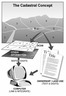
Figure 1. The Cadastral Concept. (FIG, 1995)
The Evolution of Land Administration Systems
The evolution of LAS is influenced by the changing people to land
relationships over the centuries. Even though Figure 2 depicts a Western
example of this evolving relationship, a similar evolution can be
plotted for most societies. This diagram highlights the evolution from
feudal tenures, to individual ownership, the growth of land markets
driven by the Industrial Revolution, the impact of a greater
consciousness about managing land with land use planning being a key
outcome, and, in recent times, the environmental dimension and the
social dimension in land (Ting and others, 1999). Historically, an
economic paradigm drove land markets; however this has now been
significantly tempered by environmental and more recently social
paradigms. Simply, the people to land relationships in any society are
not stable, but are continually evolving.
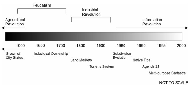
Figure 2. Evolution of people to land
relationship. (Ting and others, 1999)
In turn most civilisations developed a land administration or
cadastral response to these evolving people to land relationships.
Figure 3 depicts the evolution of these responses over the last 300
years or so in a Western context. The original focus on land taxation
expanded to support land markets, then land use planning, and, over the
last decade or so, to provide a multi-purpose role supporting
sustainable development objectives (Ting and Williamson, 1999).
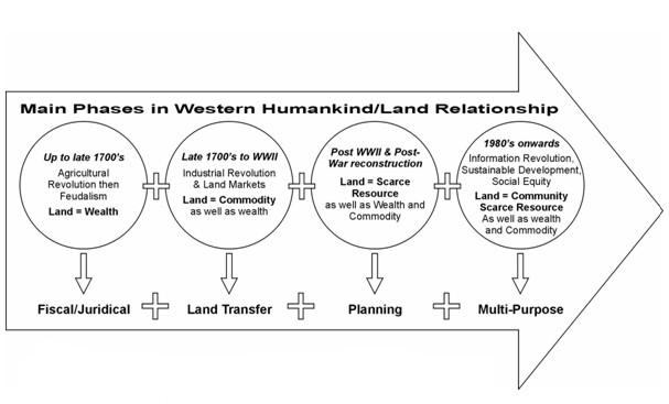
Figure 3. The Land Administration Response.
(Ting and Williamson, 1999)
Even within this evolution, current LAS must continue to service the
19th century economic paradigm by defining simple land commodities and
supporting simple trading patterns (buying, selling, leasing and
mortgaging), particularly by providing a remarkably secure parcel
titling system, an easy and relatively cheap land transfer system, and
reliable parcel definition through attainable surveying standards.
Arguably, Australia was a world leader in adapting its LASs to
support land parcel marketing. Major innovations of the Torrens system
of land registration and strata titles are copied in many other
countries. However, because of the pace of change, the capacity of LAS
to meet market needs has diminished. The land market of say 1940, is
unrecognisable in today’s modern market. After WW II, new trading
opportunities and new products were invented. Vertical villages, time
shares, mortgage backed certificates used in the secondary mortgage
market, insurance based products (including deposit bonds), land
information, property and unit trusts, and many more commodities, now
offer investment and participation opportunities to millions, either
directly or through investment or superannuation schemes. The controls
and restrictions over land have become multi-purpose, and aim at
ensuring safety standards, durable building structures, adequate service
provision, business standards, social and land use planning, and
sustainable development. The replication of land related systems in
resource and water contexts is demanding new flexibilities in our
approaches to land administration (Wallace and Williamson, 2006a).
In Australia the combination of new management styles,
computerization of activities, creation of data bases containing a
wealth of land information, and improved interoperability of valuation,
planning, address, spatial and registration information allowed much
more flexibility. However, Australian LASs remain creatures of their
history of state and territory formation. They do not service national
level trading and are especially inept in servicing trading in new
commodities. Moreover, modern societies, which are responding to the
needs of sustainable development, are now required to administer a
complex system of overlapping rights, restrictions and responsibilities
relating to land – our current land administration and cadastral systems
do not service this need. A diagrammatic representation of the
development of land administration (and cadastral) systems from a policy
focus is shown in Figure 4. Unfortunately many Australian LAS still do
not appreciate the central role they play in spatially enabling
government and as such are not achieving their full potential.
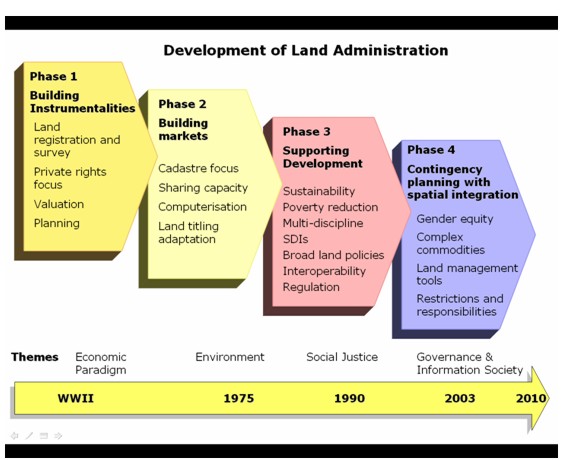
Figure 4. Development of Land Administration
(after Wallace and Williamson, 2005)
The Formalization of Tenures
Modern societies are also now realising that many rights,
restrictions and responsibilities relating to land exist without
formalisation by governments for various policy or political reasons.
This does not mean these rights, restrictions and responsibilities do
not exist, but that they have not been formalized in recognizable land
administration or equivalent frameworks. A good example is the
recognition of indigenous aboriginal rights in land in Australia in the
1980s. Prior to the Mabo and Wik High Court decisions and the resulting
legislation in Australia, indigenous rights did not formally exist.
Their existence was informal but strongly evidenced by song lines,
cultural norms and other indigenous systems, a situation still familiar
in the developing world where indigenous titles await more formal
construction.
The process of formalising tenure and rights, restrictions and
responsibilities in land is depicted in Figure 5 (Dalrymple and others,
2004 and 2005; Dalrymple, 2006). An understanding of both formal and
informal rights is important as we move to develop land administration
and cadastral systems that are sensitive to sustainable development
objectives. Additionally, we need to recognize that change management
processes and adaptation of formal systems always lag behind reality:
all mature systems will simultaneously sustain both informal and highly
formalized rights because the systems are not yet ready for emerging
interests. Frequently, some rights will be deliberately held in informal
systems: one of the largest and most significant management tools in
Australia, the trust, remains beyond the land administration
infrastructure and involves utilization of paperwork generated by
lawyers and accountants and held in their filing drawers.

Figure 5. Formalisation of tenures.
(Dalrymple, Wallace and Williamson, 2004)
Other rights involve minimal formalization for different reasons.
Residential leases, too common and too short term to warrant much
administrative action, are traditionally organized outside LAS. These
land rent-based distribution systems nevertheless remain potentially
within the purview of modern LAS, policy makers and administrators, as
illustrated by Australia’s development of a geo-referenced national
address file (GNAF) produced by PSMA Australia (PSMA, 2007). Indeed the
development of spatial, as distinct from survey, information provides
the timeliest reminder that information about land is potentially one of
the most remarkable commodities in the modern land market. Certainly
this commodity of information is of core interest to LA administrators.
Implementing and Understanding Regulations and Restrictions
While many rights, restrictions and responsibilities in land have not
been formalized, many are established by statute or regulation but are
not recorded in land registries, or any other form of register. Land
uses over time must be managed to mitigate long term deleterious impacts
and support sustainable development.
As an example, Australian problems of erosion, salinity and acidity
are well documented. Over time, attempts to manage these shared impacts
by regulating tree clearance, water access, chemical use, building
standards, and more, led to very great increases in the number of laws,
regulations and standards applying to land based activities. The lack of
coherent management of restrictions and the information they generate is
now apparent.
The problem of increasing complexity of social and environmental
restrictions over land is now straining our systems, and in some cases
failing. For example, the State of Victoria, Australia now has over 600
pieces of legislation that relate to land, and the national Australian
Government has a similar amount. Most of these are administered outside
our land administration systems. This is a world wide experience. Calls
for inclusion of restrictions on land in traditionally organised LAS are
common and international.
The idea of including “all restrictions in the land register” was a
first-grab solution that is now recognized as impractical. Society needs
a more transparent and consistent approach in dealing with these
restrictions. While modern registries are adapting to manage those
restrictions compatible with their traditional functions, spatial
enablement of governments and businesses offer different solutions
(Bennett and others, 2005, 2008a and 2008b). The management of these
many rights, restrictions and responsibilities (RRR) has introduced the
concept of adding RRR either “above or below” the land register. That is
if it is “above the register”, it is included on the register with all
the government guarantees and controls that are associated with
registered interests. If it is “below the register” the RRR are not
included on the register but use the integrity of the register or
information flowing from the register such as a geocoded street address
to reference the information.
The Changing Nature of Ownership
The rapid growth of restrictions on land in modern societies is
paralleled by a change in the nature of land ownership. Nations are
building genuine partnerships between communities and land owners, so
that environmental and business controls are more mutual endeavors.
Rather than approach controls as restrictions, the nature of ownership
is redesigned to define opportunities of owners within a framework of
responsible land uses for delivery of environmental and other gains.
This stewardship concept is familiar to many Europeans long used to the
historical, social and environmental importance of land. For these
Europeans, the social responsibilities of land owners have a much longer
heritage, with the exemplar provision in the German Constitution
insisting on the land owner’s social role. The nature of land use in The
Netherlands, given much of the land mass is below sea level, presupposes
high levels of community cooperation, and integrates land ownership
responsibilities into the broader common good. The long history of rural
villages in Denmark and public support for the Danes who live in rural
areas also encourages collaboration. (Williamson and others, 2006b)
The Australian mining industry provides typical examples of
collaborative engagement of local people, aboriginal owners and the
broader public. The Australian National Water Initiative and the
National Land and Water Resources Audit reinforce the realisation that
activities of one land owner affect others. The development of market
based instruments (MBI), such as EcoTenders and BushTenders, is an
Australian attempt to build environmental consequences into land
management. Australia’s initiatives in “unbundling” of land to create
separate, tradable commodities, including water titles, are now
established and are built into existing land administration systems as
far as possible. As yet a comprehensive analysis of the impact of
unbundling land interests on property theory and comprehensive land
management is not available.
Whatever the mechanism, modern land ownership has taken on social and
environmental consequences, at odds with the idea of an absolute
property owner. Australia and European approaches to land management are
inherently different. While Europe is generally approaching land
management as a comprehensive and holistic challenge requiring strong
government information and administration systems, Australia is creating
layers of separate commodities out of land and adapting existing LAS as
much as possible to accommodate this trading without a national
approach. In these varying national contexts, the one commonality, the
need for land information to drive land management in support of
sustainable development, will remain the universal land administration
driver of the future. (Williamson and others, 2006b)
3. LAND MARKETS
As previously stated, the land market of 1940 is unrecognisable in
today’s modern market (Figure 6). Modern land markets evolved from
systems for simple land trading to trading complex commodities. New
trading opportunities and new products were, and continue to be,
invented. The controls and restrictions over land became multi-purpose
with an increasing focus on achieving sustainable development
objectives.
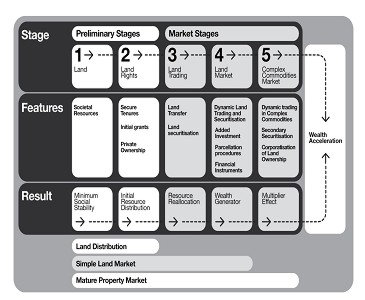
Figure 6. Evolution Of Land Markets. (Wallace
and Williamson, 2006a)
As with simple commodities such as land parcels, all commodities
require quantification and precise definition (de Soto, 2000). While LAS
have not yet incorporated the administration of complex commodities to a
significant degree, these modern complex land markets offer many
opportunities for LA administrators and associated professionals, if
they are prepared to think laterally and capitalise on their traditional
measurement, legal, technical and land management skills.
This complexity is compounded by the “unbundling of rights in land”
(ie water, biota etc) thereby adding to the range of complex commodities
available for trading. For example, the replication of land related
systems in resource and water contexts is demanding new flexibilities in
our approaches to land administration (Wallace and Williamson, 2006a).
These emerging demands will stimulate different approaches to using
cadastral information.
Our understanding of the evolution of land markets is limited, but it
must be developed if LA administrators are going to maximise the
potential of trading in complex commodities by developing appropriate
land administration systems (Wallace and Williamson, 2006a). Figure 6
shows the various stages in the evolution of land markets from simple
land trading to markets in complex commodities. The growth of a complex
commodities market showing examples of complex commodities is presented
diagrammatically in Figure 7.
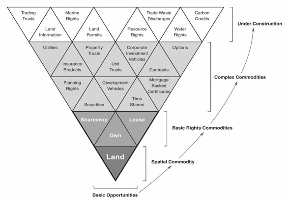
Figure 7. Complex commodities market. (Wallace
and Williamson, 2006a)
4. THE IMPORTANCE OF SPATIAL DATA INFRASTRUCTURES
All LAS require some form of spatial data infrastructure (SDI) to
provide the spatial integrity for rights, restrictions and
responsibilities relating to land, and the resulting land information.
However SDI is an evolving concept. In simple terms, it is as an
enabling platform linking data producers, providers and value adders to
data users. SDIs are crucial tools in facilitating use of spatial data
and spatial information systems. They allow the sharing of data, which
enables users to save resources, time and effort when acquiring new
datasets. Many nations and jurisdictions are investing in developing
these platforms and infrastructures to enable their stakeholders to
adopt compatible approaches to creation of distributed virtual systems
to support better decision-making. The success of these systems depends
on collaboration between all parties and their design to support
efficient access, retrieval and delivery of spatial information
(Williamson and others, 2003).
The steps to develop an SDI model vary, depending on a country’s
background and needs. However, it is important that countries develop
and follow a roadmap for SDI implementation. Aspects identified in the
roadmap include the development of an SDI vision, the required
improvements in national capacity, integration of different spatial
datasets, the establishment of partnerships, and the financial support
for an SDI. A vision within the SDI initiative is essential for sectors
involved within an SDI project and for the general public. The SDI
vision helps people to understand the government’s objectives and work
towards them. Unfortunately many land administrators under-estimate the
importance of SDIs in building efficient and effective LAS. They focus
on the immediate administrative needs and tasks to provide security of
tenure and the support for simple land trading, a narrow focus that
restricts the ability of LAS organizations to contribute to the whole of
government and wider society through spatial enablement.
SDI as an enabling platform
Effective use of spatial information requires the optimisation of
SDIs to support spatial information system design and applications, and
subsequent business uses. Initially SDIs were implemented as a mechanism
to facilitate access and sharing of spatial data hosted in distributed
GISs. Users, however, now require precise spatial information in real
time about real world objects, and the ability to develop and implement
cross-jurisdictional and inter-agency solutions to meet priorities, such
as emergency management, natural resource management, water rights
trading, and animal, pest and disease control.
To achieve this, the concept of an SDI is moving to a new business
model, in which the SDI promotes partnerships of spatial information
organisations (public/private), allowing access to a wider scope of data
and services, of greater size and complexity than they could
individually provide. SDI as an enabling platform can be viewed as an
infrastructure linking people to data (Rajabifard and others, 2006)
through linking data users and providers on the basis of the common goal
of data sharing (Figure 8). However, there is a need to move beyond a
simple understanding of SDI, and to create a common rail gauge to
support initiatives aimed at solving cross-jurisdictional and national
issues. This SDI will be the main gateway through which to discover,
access and communicate spatially enabled data and information about the
jurisdiction.
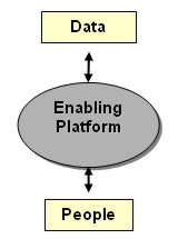
Figure 8. SDI connecting people to data.
According to Masser et al (2007), the development of SDIs over the
last 15 years, and the vision of spatially enabled government, have many
parallels, but there are also important differences. The challenge is to
develop an effective SDI that will support the vast majority of society,
who are not spatially aware, in a transparent manner. All types of
participating organisations (including governments, industries, and
academia) can thus gain access to a wider share of the information
market. This is done by organisations providing access to their own
spatial data and services, and in return, becoming contributors, and
hence gaining access to the next generation of different and more
complex services. The vision is to facilitate the integration of
existing government spatial data initiatives for access and delivery of
data and information. This environment will be more than just the
representation of feature based structures of the world. It will also
include the administration and institutional aspects of these features,
enabling both technical and institutional aspects to be incorporated
into decision-making. Following this direction, in Australia for
example, researchers have defined an enabling platform called Virtual
Australia (Rajabifard and others, 2006). The concept and delivery of
Virtual Australia aim to enable government and other users from all
industries and information sectors to access both spatial information
(generally held by governments) and applications which utilise spatial
information (developed by the private sector and governments). The next
step in the evolution of SDIs is their role as an enabling platform in
support of a spatially enabled society (Rajabifard, 2007).
SDI and Sustainable Development
While SDIs play an essential role in supporting LAS, they also have a
wider role in supporting sustainable development objectives. Achievement
of sustainable development is not possible without a comprehensive
understanding of the changing natural environment, and monitoring the
impact of human activities by integrating both the virtual
representations of the built and natural environments. Despite the
significance of data integration however, many jurisdictions have
fragmented institutional arrangements and data custodianship in the
built and natural information areas. For example, the land
administration, cadastral or land titles office (which has a key role in
providing built environment, people relevant, data) is often separated
from state or national mapping organizations which have the
responsibility of managing the natural environment data. This
fragmentation among data custodians has brought about a diversity of
approaches in data acquisition, data models, maintenance and sharing.
Many countries are attempting to address these inconsistencies through
development of national SDIs. However, further steps of a framework and
associated tools to facilitate integration of multi-sourced data, are
also needed. (Mohammadi and others, 2006 and 2007). An SDI can provide
the institutional, administrative, and technical basis to ensure the
national consistency of content to meet user needs in the context of
sustainable development.
5. THE CONTRIBUTION OF LAND ADMINISTRATION SYSTEMS TO iLand
This brief review of the evolution of cadastres, land administration
systems, SDIs and land markets shows that the traditional concept of
cadastral parcels representing the built environmental landscape is
being replaced by a complex arrangement of over-lapping tenures
reflecting a wide range of rights, restrictions and responsibilities,
and that a new range of complex commodities, building on this trend, has
emerged. To a large extent these developments are driven by the desire
of societies to better meet sustainable development objectives. There is
no reason to believe that this trend will not continue as all societies
better appreciate the needs to manage the environment for future
generations and deliver stable tenure and equity in land distribution.
While the growth of complex commodities offers huge potential for
cadastral systems to play a greater role in delivering sustainable
development objectives and supporting the trading of these complex
commodities in particular, one complex commodity, land information, is
capable of transforming the way government and the private sector do
business. The potential offered by land information in a virtual world
in spatially enabling government is so large, it is difficult to
contemplate. We are starting to glimpse this potential in such
initiatives as Google Earth and Microsoft’s Virtual Earth, but this is
barely a start. These predictions of the importance of spatial
information are also recognized in many influential forums including in
the prestigious journal NATURE, and in the Australian Prime Minister’s
statement on frontier technologies for building and transforming
Australia’s industries (December, 2002) – both these examples place the
growth and importance of the geosciences alongside nanotechnology and
biotechnology as transformational technologies in the decade ahead.
With regard to the importance and growth in land administration and
its cadastral core as shown in Figure 4, Figure 9 (Williamson, 2006)
uses a a technology focus to show the transformation of land
administration and cadastral systems over the last three decades or so.
The figure shows five stages in the evolution of our cadastral systems
from a technology perspective. The first stage recognizes that
historically cadastral systems were manually operated with all maps and
indexes hard copy. At this stage, the cadastre focused on security of
tenure and simple land trading. The 1980s saw the computersiation of
these cadastral records with the creation of digital cadastral data
bases (DCDBs) and computerized indexes. While this computerization did
not change the role of the land registry or cadastre, it was a catalyst
felt world wide, initiating institutional change to start bringing the
traditionally separate functions of surveying and mapping, cadastre and
land registration together.
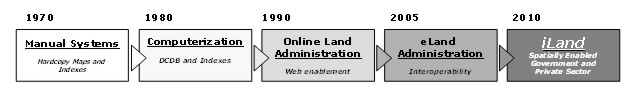
Figure 9. Technical evolution of land
administration
With the growth of the Internet, the 1990s saw governments start to
web enable their land administration systems as they became more service
oriented. As a result, access over the Internet to cadastral maps and
data was possible. This facilitated digital lodgment of cadastral data
and opened up the era of e-conveyancing. However, the focus on security
of tenure and simple land trading within separate institutional data
silos still continued. At the same time, this era also saw the
establishment of the spatial data infrastructure (SDI) concept (see
Williamson and others, 2003 and Rajabifard and others, 2005). The SDI
concept, together with web enablement, stimulated the integration of
different data sets (and particularly the natural and built
environmental data sets) with these integrated data sets now considered
critical infrastructure for any nation state.
Now a significant refinement of web enabled land administration
systems aims to achieve interoperability between disparate data sets,
facilitated by the partnership business model. This marks the start of
an era where basic land, property and cadastral information can form an
integrating technology between many different businesses in government,
such as planning, taxation, land development and local government. An
example is the new Shared Land Information Platform (SLIP) being
developed by the state Government of Western Australia (Searle and
Britton, 2005). A key catalyst for interoperability is also the
development of high integrity geocoded national street address files,
such as the Australian GNAF (Paull and Marwick, 2005 and PSMA, 2007).
Similarly, “mesh blocks”, small aggregations of land parcels, are
revolutionizing the way census and demographic data is collected,
managed and used (Toole and Blanchfield, 2005). These refinements
potentially extend to better management of the complex arrangement of
rights, restrictions and responsibilities relating to land that are
essential to achieving sustainable development objectives (Bennett and
others, 2005, 2008a and 2008b). They also stimulate re-engineering of
cadastral data models to facilitate interoperability between the
cadastre, land use planning and land taxation for example (Kalantari and
others, 2005, 2006 and 2008).
The future focus will be on realising the potential of land and
cadastral information. The use and potential of cadastral data as an
enabling technology or infrastructure will outweigh its value to
government from supporting simple land trading and security of tenure.
Cadastres will not stop at the water’s edge; they will include a marine
dimension where there is a continuum between the land and marine
environments. Without this basic infrastructure the management of the
exceptionally sensitive coastal zone is very difficult, if not
impossible (Strain et al, 2006; Wallace and Williamson, 2006b, Vaez and
others, 2007).
However this is not the end of the story – researchers,
practitioners, big business and government see the potential from
linking “location” or the “where” to most activities, polices and
strategies, just over the horizon. Companies like Google and Microsoft
are actively negotiating to gain access to the world’s large scale built
and natural environmental data bases. In Australia, they are negotiating
to get access to the national cadastral and property maps as well as to
GNAF. At the same time, new technologies are being built on top of these
enabling infrastructures such as the Spatial Smart Tag which is a joint
initiative in Australia between government, the private sector and
Microsoft (McKenzie, 2005). We are starting to realise that cadastral
and land related information will dramatically spatially enable both
government and the private sectors, and society in general. In the near
future, spatially enabled systems will underpin health delivery, all
forms of taxation, counter-terrorism, environmental management, most
business processes, elections and emergency response, for example (see
for example and Rajabifard, 2007 and OSDM, 2007).
In the future, cadastral data will be seen as information and a new
concept called iLand will become the paradigm for the next
decade. iLand is a vision of integrated, spatially enabled, land
information available on the Internet. iLand enables the “where”
in government policies and information. The vision as shown
diagrammatically in Figure 10 is based on the engineering paradigm where
hard questions receive “design, construct, implement and manage”
solutions. In iLand all major government information systems are
spatially enabled, and the “where” or location provided by spatial
information is regarded as a common good made available to citizens and
businesses to encourage creativity, efficiency and product development.
The LAS and cadastre is even more significant in iLand. Modern
land administration demands LA infrastructure as fundamental if land
information is to be capable of supporting those “relative” information
attributes about people, interests, prices, and transactions, so vital
for land registries and taxation.
All these initiatives come together to support a new vision for
managing land information - iLand. (Williamson, Wallace and
Rajabifard, 2006)
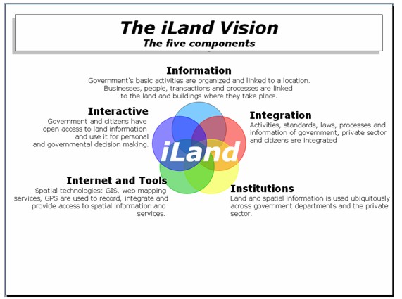
Figure 10. The iLand Vision.
(Williamson and Wallace, 2006)
While future markets of complex commodities will continue to rely on
the underlying cadastre and land administration system, will LA
administrators embrace the definition and management of complex
commodities that do not rely on traditional cadastral boundaries and
that require merging of value, building purpose, land use and personal
owner information? How many LA administrators are capable of seeing the
international context of land information and its importance to their
national government in presentation of its investment face to the world?
Will they embrace iLand?
6. THE ROLE OF CADASTRES AND LAND ADMINISTRATION IN SPATIALLY
ENABLING GOVERNMENT
Governments can be regarded as spatially enabled when they treat
location and spatial information as common goods made available to
citizens and businesses to encourage creativity and product development.
The vision of a spatially enabled government involves establishing an
enabling infrastructure to facilitate use of place or location to
organise information about activities of people and businesses, and
about government actions, decisions and polices. Once the infrastructure
is built, spatial enablement allows government information and services,
business transactions and community activities to be linked to places or
locations. Given the potential of new technologies, use of place or
location will facilitate the evaluation and analysis of both spatial and
non-spatial relationships between people, business transactions and
government. (Williamson and Wallace, 2006; Rajabifard, 2007; OSDM, 2007;
and PCGIAP, 2007)
Most governments already have considerable infrastructure and
administrative systems for better management of land and resources.
Basic information creating processes are cadastral surveying that
identifies land; its supporting digital cadastral database (DCDB) that
provides the spatial integrity and unique land parcel identification;
registering land that supports simple land trading (buying, selling,
mortgaging and leasing land); running land information systems (LIS) for
land development, valuation and land use planning; and geographic
information systems (GIS) that provide mapping and resource information.
For modern governments at all stages of development, one question is how
best to integrate these processes, especially to offer them in an
Internet enabled eGovernment environment.
Twenty years ago, each process and collection of information, was
distinct and separate. Two changes in the world at large challenged this
silo approach. First, thanks to improvements in technology, the
infrastructure available to support modern land and resource management
now spans three distinct environments: the natural, the built and the
virtual environments. Second, the pressures on managers created by
increased populations, environmental degradation, water scarcity and
climate change, require governments to have more accurate and
comprehensive information than ever before.
How governments treat their land information will define their
transformation of internal and external processes. The eLand
administration concept as part of eGovernment initiatives is now
moving to a wider use of spatially enabled land information, expressed
in the concept of iLand - integrated, interactive spatial
information available on the Internet. The conversion of processes to
spatially enabled systems will increase useability, access and
visualisation of information.
7. THE ROLE OF THE CADASTRE IN SUPPORTING SUSTAINABLE DEVELOPMENT
These developments and drivers will introduce complexity into the
design of LAS as they adapt to assist delivery of a broader range of
public policy and economic goals, the most important of which is
sustainable development. However re-engineering land administration
systems to support sustainable development objectives is a major change
in direction for traditional LAS and is a significant challenge (Enemark
and others, 2005).
In the proceeding sections this paper has described how cadastres,
SDIs and LAS interact to spatially enable government and wider society
in pursuit of sustainable development objectives. These relationships
are shown diagrammatically in Figure 11 below. The diagram shows the
critical role that the cadastre plays in providing built environmental
data in a national SDI and how the integrated SDI can then contribute to
a LAS that supports effective land management. It is only by bringing
together the SDI and the LAS that an integrated land policy can be
implemented to support sustainable development. This integration also
provides the key role of spatial enablement of the LAS, as well as
government and wider society. Ironically only a relatively small number
of countries, the “developed countries” have the ability at the present
of achieving this objective. However the model does provide a road map
for less developed countries to move down this path.
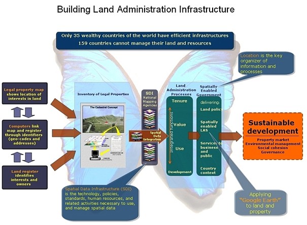
Figure 11. The role of the cadastre in
building land administration infrastructures.
These global trends to move LAS down this path, and the national and
historical methods used to incorporate sustainable development
objectives into national LAS were examined in an Expert Group Meeting
(EGM) in Melbourne in December, 2006 with leading stakeholders and land
policy experts from Australia and Europe. (Williamson and others,
2006a). Distinctions between approaches used in modern European
democracies and in Australia were identified. The European approach
showed more integration between the standard LAS activities and measures
of sustainability. Australian policy was more fractured, partly due to
federation and the constitutional distribution of powers. In contrast,
pioneering in Australian LAS lay in incorporating market based
instruments (MBI) and complex commodities into LAS, and revitalization
of land information through inventive Web based initiatives.
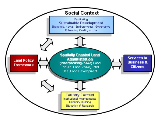
Figure 12. Land management vision. (Williamson
and others, 2006b)
The EGM developed a vision for future LAS sufficiently flexible to
adapt to this changing world of new technology, novel market demands,
and sustainable development, as shown in Figure 12. This vision
incorporates and builds upon the above vision of iLand and can be
considered an infrastructure or enabling platform to support spatial
enablement of government. (Wallace and others, 2006; Williamson and
others, 2006a and 2006b). This vision is explained at a more practical
level in Figure 11 above.
8. CONCLUSION
People to land relationships are dynamic. The land administration and
cadastral responses to managing these relationships are also dynamic and
continually evolving. A central objective of the resulting land
administration systems is to serve efficient and effective land markets.
Because of sustainable development and technology drivers, modern land
markets now trade in complex commodities, however our current land
administration systems and the majority of the skills of land surveyors,
lawyers and LA administrators are focused on the more traditional
processes supporting simple land trading. The growth in complex
commodities offers many opportunities for LA administrators if they are
prepared to think laterally and more strategically.
Land information has grown in importance over the last few decades,
and is considered by many to be more important and useful to government
than in its traditional role of supporting security of tenure and simple
land trading. Land administration systems and their core cadastral
components are evolving into a new vision and essential infrastructure
called iLand that spatially enables government and provides the
“where” for all government decisions, polices and implementation
strategies. This vision requires a clear understanding and institutional
and legal structures that link the cadastre to the SDI and the wider
LAS. Without this understanding and interaction delivering the vision is
very difficult if not impossible. Ultimately, spatially enabled land
information will provide the essential link between land administration
and sustainable development.
This brief account of the future delivers a challenge to land
administration officials to design and build modern land administration
and cadastral systems capable of supporting the creation, administration
and trading of complex commodities, and particularly to use land
information to spatially enable government and society in general.
Unfortunately, unless land administration systems are refocused on
delivering transparent and vital land information and enabling
platforms, modern economies will have difficulty meeting sustainable
development objectives and achieving their economic potential.
REFERENCES
NOTE: Most referenced articles that have been authored or co-authored
by the author (Ian Williamson) are available at
http://www.geom.unimelb.edu.au/people/ipw.html
Bennett, R., Wallace, J. and Williamson, I.P. 2005. Integrated land
administration in Australia. Proceedings of the Spatial Sciences
Institute Biennial Conference, Melbourne, Australia, 12-16 September,
2005. CD ROM.
Bennett, R., Wallace J. and Williamson, I.P.2008a, Organising
property information for sustainable land administration. Journal of
Land Use Policy, Vol. 25, No. 1, 126-138.
Bennett, R., Wallace, J. and I. P. Williamson 2008b. A toolbox for
mapping and managing new interests over land. The Survey Review, 40, 307
pp.43-53 (January 2008)
Dalrymple, K, Wallace, J. and Williamson, I.P., 2004. Innovations in
Land Policy and Rural Tenures. 3rd FIG Regional Conference, Jakarata,
Indonesia, October 4-7.
http://www.fig.net/pub/jakarta/papers/ts_10/ts_10_1_dalrymple_etal.pdf
Dalrymple, K, Wallace, J. and Williamson, I.P. 2005. Transferring our
knowledge and systems – tenure formalisation. Proceedings of the Spatial
Sciences Institute Biennial Conference, Melbourne, Australia, 12-16
September, 2005. CD ROM.
Dalrymple, K. 2006. Expanding rural land tenures to alleviate
poverty. PhD thesis. University of Melbourne. See
http://www.geom.unimelb.edu.au/research/SDI_research/publications/Dalrymple%20PhD%20Thesis.pdf
Accessed 15 December, 2007.
De Soto, Hernando, 2000, The Mystery of Capital: Why Capitalism
Triumphs in the West and Fails Everywhere Else, Bantam Press, London,
235 pp
Enemark, S, Williamson, I.P and J. Wallace, 2005, Building modern
land administration systems in developed economies, Spatial Science
Journal, 2/50, 51-68
FIG, 1995. The FIG Statement on the Cadastre. International
Federation of Surveyors, FIG Publication No 11.
http://www.fig7.org.uk/publications/cadastre/statement_on_cadastre.html
FIG, 1998. CADASTRE 2014. International Federation of Surveyors. (http://www.fig.net/commission7/reports/cad2014/)
FIG, 1999. Bathurst Declaration on Land Administration for
Sustainable Development. International Federation of Surveyors (http://www.fig.net/pub/figpub/pub21/figpub21.htm)
Kalantari, M., Rajabifard, A., Wallace, J. and Williamson, I.P. 2005.
Towards e-land Administration – Australian on-line land information
services. Proceedings of the Spatial Sciences Institute Biennial
Conference, Melbourne, Australia, 12-16 September, 2005. CD ROM.
Kalantari, M., Rajabifard, A., Wallace, J. and Williamson, I.P. 2006.
A new vision on cadastral data models. FIG Congress Proceedings, Munich,
Germany, 8-13 October, 2006. See
http://www.fig.net/pub/fig2006/index.htm Accessed 14 December, 2007.
Kalantari, M. , Rajabifard, A., Wallace, J. & Williamson, I., 2008.
Spatially Referenced Legal Property Objects, Journal of Land Use Policy
(in press). See
http://dx.doi.org/10.1016/j.landusepol.2007.04.004. Accessed 14
December, 2007.
Masser, I., Rajabifard, A., Binns, A., and Williamson, I. 2007,
Spatially Enabling Governments through SDI implementation, International
Journal of Geographical Information Science Vol. 21, July, 1-16.
Mohammadi, H., Rajabifard, A., Binns, A. and Williamson, I.P. 2006,
Bridging SDI Design Gaps with Facilitating Multi-source Data
Integration, Coordinates, Vol II, Issue 5, May 2006.
Mohammadi, H., Rajabifard, A., Binns, A. and Williamson, I.P. 2007,
Spatial Data Integration Challenges: Australian Case Studies,
Proceedings of SSC 2007, The national biennial Conference of the Spatial
Sciences Institute, 14-18 May, Hobart, Australia.
McKenzie, D. 2005. Victorian Spatial Smart Tag – How to bring spatial
information to government’s non technical users. Proceedings of the
Spatial Sciences Institute Biennial Conference, Melbourne, Australia,
12-16 September, 2005. CD ROM.
OSDM, 2007. Spatially Enabling Government. Office of Spatial Data
Management (OSDM), Australian Government.
http://www.osdm.gov.au/seg/
Accessed 14 December, 2007.
PSMA, 2007. GNAF. PSMA Australia,
http://www.psma.com.au/ Accessed 14 December, 2007
PCGIAP, 2007. Working Group 3 (Spatially Enabling Government).
Permanent Committee for GIS Infrastructure for Asia and the Pacific
(PCGIAP). See
http://219.238.166.217/pcgiap/98wg/wg3_index.htm Accessed 14
December, 2007.
Paull, D. and Marwick, B. 2005. Maintaining Australia’s Geocoded
National Address File (GNAF). Proceedings of the Spatial Sciences
Institute Biennial Conference, Melbourne, Australia, 12-16 September,
2005. CD ROM.
Rajabifard, A., Binns, A. and Williamson, I. 2005, Development of a
Virtual Australia Utilising an SDI Enabled Platform, Global Spatial Data
Infrastructure 8 and FIG Working Week Conference, 14-18 April, Cairo
Egypt.
Rajabifard, A., Binns, A. and Williamson, I. 2006, Virtual Australia
– an enabling platform to improve opportunities in the spatial
information industry, Journal of Spatial Science, Special Edition, Vol.
51, No. 1.
Rajabifard, A. (Editor) 2007, Towards a spatially enabled society.
Department of Geomatics, University of Melbourne, Australia, 399 pages.
(also see
http://www.ianwilliamson.net/SEG_flash.htm Accessed 14 December,
2007)
Searle, G. and Britton, DM. 2005. Government working together through
a shared land information platform (SLIP). Proceedings of the Spatial
Sciences Institute Biennial Conference, Melbourne, Australia, 12-16
September, 2005. CD ROM.
Strain, L., Rajabifard, A. and Williamson, I.P. 2006. Marine
Administration and Spatial Data Infrastructures. Marine Policy. 30
(2006):431-441.
Ting, L., Williamson, I.P. Grant, D. and Parker, J. 1999.
Understanding the Evolution of Land Administration Systems in Some
Common Law Countries. The Survey Review Vol. 35, No. 272, 83-102.
Ting, L. and Williamson, I.P. 1999. Cadastral trends: A synthesis.
The Australian Surveyor Vol. 4, No. 1, 46-54.
Toole, M and Blanchfield, F. 2005. Mesh blocks – from theory to
practice. Proceedings of the Spatial Sciences Institute Biennial
Conference, Melbourne, Australia, 12-16 September, 2005. CD ROM.
Vaez, S., Rajabifard, A., Binns, A. & Williamson, I. (2007), Seamless
SDI Model to Facilitate Spatially Enabled Land Sea Interface,
Proceedings of SSC 2007 ,The national biennial Conference of the Spatial
Sciences Institute, May, Hobart, Australia. See
http://www.geom.unimelb.edu.au/research/SDI_research/publications/ianpubli.htm
Accessed 15 December, 2007.
Wallace, J. and Williamson, I.P. 2005. A vision for spatially
informed land administration in Australia. Proceedings of the Spatial
Sciences Institute Biennial Conference, Melbourne, Australia, 12-16
September, 2005. CD ROM.
Wallace, J. and I.P. Williamson, 2006a. “Building Land Markets”,
Journal of Land Use Policy, Vol 23/2 pp 123-135
Wallace, J. and Williamson, I.P. 2006b. Registration of Marine
Interests in Asia-Pacific Region. Marine Policy. 30(3):207-219.
Wallace, J., Williamson, I.P. and S. Enemark, 2006. “Building a
national vision for spatially enabled land administration in Australia”,
In Sustainability and Land Administration Systems, Department of
Geomatics, Melbourne, 237-250.
Williamson, I.P. 2006. A Land Administration Vision. In
Sustainability and Land Administration Systems, Department of Geomatics,
Melbourne, 3-16.
Williamson, I.P., Rajabifard, A. and Feeney, M-E.F. (Editors). 2003.
Developing Spatial Data Infrastructures – From concept to reality.
Taylor and Francis. 316p.
Williamson, I.P., Enemark, S. and J.Wallace (eds), 2006a.
Sustainability and Land Administration Systems, Department of Geomatics,
Melbourne, 271p.
Williamson, I.P., Enemark, S. and J. Wallace, 2006b, “Incorporating
sustainable development objectives into land administration”,
Proceedings of the XXIII FIG Congress, Shaping the Change, TS 22.
Munich, Germany, October 8-13, 2006.
Williamson, I.P. and J. Wallace, 2006, “Spatially enabling
governments: A new direction for land administration systems”,
Proceedings of the XXIII FIG Congress, Shaping the Change, TS 23.
Munich, Germany, October 8-13, 2006.
Williamson, I.P., Wallace, J. and A. Rajabifard, 2006. Spatially
enabling governments: A new vision for spatial information. 17th
UNRCC-AP Conference and 12th Meeting of the PCGIAP, Bangkok, Thailand.
18-22 September 2006.
Williamson, I.P., Rajabifard, A. and J. Wallace, 2007. Spatially
enabling government – an international challenge. International Workshop
on “Spatial Enablement of Government and NSDI – Policy Implications.
Permanent Committee for GIS Infrastructure for Asia and the Pacific,
Seoul, Korea, 12 June 2007.
CONTACTS
Professor Ian Williamson
Professor of Surveying and Land Information
Department of Geomatics
Centre for Spatial Data Infrastructures and Land Administration
The University of Melbourne, Parkville, Victoria, Australia 3010
Email: ianpw@unimelb.edu.au
http://www.geom.unimelb.edu.au/people/ipw.html
 |


