Article of the Month - January 2019
|
The Future of Authoritative
Geospatial Data in the Big Data World – Trends, Opportunities and
Challenges
Kevin
Mcdougall and Saman Koswatte, Australia
Kevin
Mcdougall and Saman Koswatte, Australia
This article in .pdf-format
(16 pages)
This paper was presented at the FIG Commission 3 meeting in Naples,
Italy and was chosen by commission 3 as paper of the month. This paper
examines the drivers of the “Big Data” phenomena and look to
identify how authoritative and big data may co-exist.
SUMMARY
The volume of data and its availability through the internet
is impacting us all. The traditional geospatial industries
and users have been early adopters of technology, initially
through the early development of geographic information systems
and more recently via information and communication technology
(ICT) advances in data sharing and the internet. Mobile
technology and the rapid adoption of social media applications
has further accelerated the accessibility, sharing and
distribution of all forms of data including geospatial data. The
popularity of crowd-sourced data (CSD) now provides users with a
high degree of information currency and availability but this
must also be balanced with a level of quality such as spatial
accuracy, reliability, credibility and relevance. National
and sub-national mapping agencies have traditionally been the
custodians of authoritative geospatial data, but the lack of
currency of some authoritative data sets has been questioned.
To this end, mapping agencies are transitioning from inwardly
focussed and closed agencies to outwardly looking and accessible
infrastructures of spatial data. The Internet of Things
(IoT) and the ability to inter-connect and link data provides
the opportunity to leverage the vast data, information and
knowledge sources across the globe. This paper will examine the
drivers of the “Big Data” phenomena and look to identify how
authoritative and big data may co-exist.
1. INTRODUCTION
There is no doubt that advances in technology is impacting
significantly across society. In particular, the
connectivity provided through advances in information and
communication technology (ICT) have enabled citizens, businesses
and governments to connect and exchange data with increasing
regularity and volume. With the exponential growth of data
sensors and their connectivity through the internet, the volume,
frequency and variety of data has changed dramatically in the
past decade. The connectivity of devices such as home
appliances, vehicles, surveillance cameras and environmental
sensors is often termed the Internet of things (IoT). In
addition, the capability of cloud computing platforms to store,
organise and distribute this data has created massive
inter-connected repositories of data that is commonly termed
“Big Data”.
In many instances, the digital exchange of data has replaced
direct human interaction through the automation of processes and
the use of artificial intelligence. The geospatial industries
and users have been early adopters of this technology, initially
through the early development of geographic information systems
(GIS) and more recently via ICT advances in data sharing and the
internet. Mobile technology and the rapid adoption of
social media and applications have further accelerated the
accessibility, sharing and distribution of all forms of data,
particularly geospatial data. Crowd-sourced data (CSD) now
enables users to collect and distribute information that has a
high degree of information currency. However, the availability
of CSD must also be balanced with an understanding of data
quality including spatial accuracy, reliability, credibility and
relevance.
The rate of change of technology has been extremely rapid
when considered in the context of the operations of traditional
geospatial mapping agencies. This paper will examine the
developments of the “Big Data” phenomena in the context of the
trends, opportunities and challenges in respect to the
traditional geospatial custodian and authoritative data
environments. The transition of mapping agencies from
inwardly focussed organisations to increasing outwardly looking
and accessible data infrastructures has been achieved in a
relatively short period of time. This has been
accomplished through not only the developments in ICT and
positioning technology, but through changes in government
policies and the realisation that existing systems were not
servicing the key stakeholders – the citizens.
This paper will firstly cover the progress of the digital
geospatial data repositories and their transition towards
spatial data infrastructures (SDIs). The development of more
open data frameworks and policies, and the rapid increase in the
quantity and variability of data, have created a number of
challenges and opportunities for mapping agencies. The
ability to inter-connect and link data has provided the
opportunity to leverage the vast data, information and knowledge
sources across the globe. However, the geospatial data
collection and management approaches of the past may not be
optimal in the current big data environment. Data veracity,
volume, accessibility and the rate of change means that new
approaches are required to understand, analyse, consume and
visualise geospatial data solutions. Data mining, data analytics
and artificial intelligence are now common practice within our
search engines, but how can these approaches be utilised to
improve the value and reliability of our authoritative data
sources?
2. Authoritative Geospatial Data and Spatial Data
Infrastructures
The term ‘authoritative geospatial data’ is used to describe a
data set that is officially recognized data that can be
certified and is provided by an authoritative source. An
authoritative source is an entity (usually a government agency)
that is given authority to manage or develop data for a
particular business purpose. Trusted data, or a trusted source,
is often a term associated with authoritative data, however, it
can also refer to a subsidiary source or subset of an
authoritative data set. The data may be considered to be trusted
if there is an official process for compiling the data to
produce the data subset or a new data set.
In most countries, authoritative geospatial data is generally
the responsibility of National Mapping Agencies (NMAs). Lower
levels of government such as state and local government may also
assume responsibility for the acquisition and maintenance of
authoritative geospatial data sets. Traditionally these data
sets have included foundational geospatial data themes that have
supported core government and business operations. In Australia
and New Zealand the Foundation Spatial Data Framework
(http://fsdf.org.au) identifies ten key authoritative geospatial
themes including:
- Street address for a home or business
- Administrative boundaries
- Geodetic framework
- Place names and gazetteer
- Cadastre and land parcels
- Water including rivers, stream, aquifers and lakes
- Imagery from satellite and airborne platforms
- Transport networks including roads, streets, highways,
railways, airports, ports
- Land use and land cover
- Elevation data including topography and depth
In addition to the foundational geospatial data detailed above,
other geospatial data sets may also be considered to be
authoritative by particular government agencies.
When exploring the evolution of SDIs, it can be seen that the
majority of SDIs have been led by national mapping agencies of
various countries (McDougall 2006) and have considered users as
passive recipients of this data (Budhathoki & Nedovic-Budic
2008). However, users are now active users of vast quantities of
data and can also potentially contribute towards the development
of SDI. In addressing this issue Budhathoki and Nedovic-Budic
(2008) suggest we should reconceptualise the role of the ‘user’
of spatial data infrastructures to be a ‘producer’ and to
include crowd-sourced spatial data in the SDI-related
processes.
Traditionally, SDIs have a top down structure in which
organisations govern all the processes and the user generally
receives the final product. This is a mismatch with the new
concepts of the interactive web and the notion of crowd-sourced
data. Hence, Bishr and Kuhn (2007) suggest to invert the process
from top-down to bottom-up which clears the path for the next
generation SDIs. In the 1990s, the accepted spatial data model
was in pyramid style (Figure 1) which was based on government
data sources, but in more recent years, this pyramid is
increasingly inverted (Bishr & Kuhn 2007). Related Application
Programming Interfaces (APIs) can make SDIs more user-friendly
and therefore ‘it is likely that SDIs and data stores will need
to be retro-fashioned into API interrogation systems to ease the
integration of past and future data sets’ (Harris & Lafone
2012). Bakri and Fairbairn (2011) developed a semantic
similarity testing model for connecting user generated content
and formal data sources as connecting disparate data models
requires the generation of a common domain language.
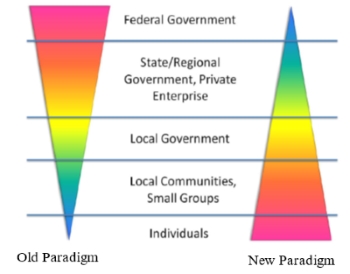
Figure 1: The spatial data sources old
and new paradigms (Harris and Lafone, 2012)
3. SDI and crowd-sourced geospatial data
A key issue with respect to SDIs is the maintenance of their
spatial data currency. There are thousands of SDIs throughout
the world from regional, state and local levels (Budhathoki &
Nedovic-Budic 2008). In the meantime, the seven billion humans
‘constantly moving about the planet collectively possess an
incredibly rich store of knowledge about the surface of the
earth and its properties’ (Goodchild 2007). The popularity of
using location sensor enabled (GNSS – Global Navigation
Satellite Systems) mobile devices along with interactive web
services like Google Maps or Open Street Maps (OSM), have
created marvellous platforms for citizens to engage in mapping
related activities (Elwood 2008). These platforms can
support and encourage crowd-sourced geospatial data.
The voluntarily engagement of creating geographic information
is not new (Goodchild 2007). However, researchers are still
struggling to figure out the motivation of volunteers to
generate geographic related information. Additionally,
sensor-enabled devices ‘can collect data and report phenomena
more easily and cheaply than through official sources’
(Diaz et al. 2012). The information infrastructures, via the
IoTs, and easily accessible positioning devices (GNSS) has
enabled ‘users from many differing and diverse backgrounds’
(McDougall, 2009) to ‘share and learn from their
experiences through text (blogs), photos (Flickr, Picasa,
Panoramio) and maps (GoogleMaps, GoogleEarth, OSM) not only
seeking but also providing information’ (Spinsanti & Ostermann
2010).
SDIs are generally considered as more formal infrastructures,
being highly institutionalised and having more traditional
architectures. In line with the SDI framework, each dataset
usually undergoes thorough standardisation procedures and SDI
data is generally handled by skilled and qualified people.
Therefore, the cost of creation and management is high. SDIs are
mainly held by governments and are mostly standards centric as
this is important for structuring and communicating data. The
standardisation is by means of structure (syntax) as well as
meaning (semantic) (Hart & Dolbear 2013). Generally, the
crowd-sourced geospatial data comes from citizens and hence the
information is often unstructured, improperly documented and
loosely coupled with metadata. However, crowd generated
geospatial data is more current and diverse in contrast to SDI.
Jackson et al. (2010) studied the synergistic use of
authoritative government and crowd-sourced data for emergency
response. They critically compared the clash of two paradigms of
crowd-sourced data and authoritative data as identified in Table
1.
Table1: A comparison of two paradigms: Crowd-sourcing and
Authoritative Data (Jackson et al., 2010)
| Crowd-sourcing
|
|
Authoritative
Government Data |
| ‘Simple’ consumer
driven Web services for data collection and processing.
|
Vs. |
‘Complex’ institutional survey and GIS applications.
|
|
Near ‘real-time’ data collection and continuing data
input allowing trend analysis.
|
Vs. |
‘Historic’ and ‘snap-shot’ map data.
|
|
Free ‘un-calibrated’ data but often at high
resolution and up-to-the minute.
|
Vs. |
Quality assured ‘expensive’ data. |
|
‘Unstructured’ and mass consumer driven metadata and
mashups.
|
Vs. |
‘Structured’ and
institutional metadata in defined but often rigid
ontologies. |
|
Unconstrained capture and distribution of spatial data
from ‘ubiquitous’ mobile devices with high resolution
cameras and positioning capabilities.
|
Vs. |
‘Controlled’ licensing, access policies and digital
rights.
|
|
Non-systematic and incomplete coverage.
|
|
Systematic and comprehensive coverage.
|
As can be noted in this table the two forms of data may seem
as if they are diametrically opposed.
Often a major deficiency with authoritative data held in SDIs is
their lack of currency which is often the result of the time
consuming data collection, checking and management by government
agencies. Processes to capture, compile, generate and
update authoritative geospatial data have been developed by
agencies over long periods of time and were commonly aligned to
traditional map production operations. Although technologies
have dramatically improved the performance and processes to
update many of the data themes, bottlenecks still exist in a
number of the processes. These bottlenecks have been
further exacerbated through the downsizing of mapping
authorities as many of the existing production processes are
either no longer required or can be more efficiently undertaken
by commercial organisations. The reluctance of mapping
agencies to use crowd-sourced data is slowly changing and many
organisations are now adapting their processes to use current
data user generated data to improve their authoritative data
sets.
4. Big Geospatial Data
Geospatial data has always been considered to have more
complex and larger data sets relative to many other
applications. The graphical and visual context of
geospatial data, particularly imagery, has to some extent,
prepared surveyors and geospatial professionals for the data
centric future that now exists. The term “big data” was coined
over 20 years ago although it has only developed a much clearer
focus in the past decade as a result of technological
developments, increased use of sensors and the proliferation of
mobile communication technologies. Li et al. (2016)
identified that big data can be classified as either
unstructured or structured data sets with massive volumes that
cannot be easily captured, stored, manipulated, analysed,
managed or presented by traditional hardware, software and
database technologies.
Big data characteristics have been described via a range of
characteristics which seek to differentiate it from other forms
of data (Evans et al. 2014; Li et al. 2016). The six Vs provide
a useful starting position in understanding the challenges that
geospatial scientists, surveyors and users are facing when big
geospatial data is considered (Li et al. 2016). These
characteristics include:
- Volume
- Variety
- Velocity
- Veracity
- Visualisation, and
- Visibility
The volume of data is perhaps the most obvious characteristic
of big data. Large geospatial data sets that are now commonly
acquired and used in the form of remotely sensed imagery, point
cloud data, location sensors and social media are creating data
in the petabytes. The data sets are not only of a much
higher resolution but they are also being captured more
regularly by more sensors. This presents not only challenges
with storage but challenges with integrating, resourcing and
analysing the data.
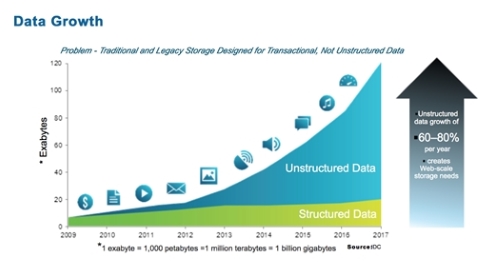
Figure 2: Big data
growth has been exponential (Source: www.dlctt.com)
The variety of data is also ever increasing and changing.
Data is being captured in traditional vector and raster formats
as well as point clouds, text, geo-tagged imagery, building
information models (BIM) and sensors of various forms.
With the variety of data comes a variety of data formats, some
structured and many unstructured, which further complicates the
analysis of the data. Many data sets have proprietary formats
that do not readily comply with data exchange protocols. The
recent data breaches by a number of large corporations has
highlighted the need to also remove personal identifiers that
are often incorporated within these data sets.
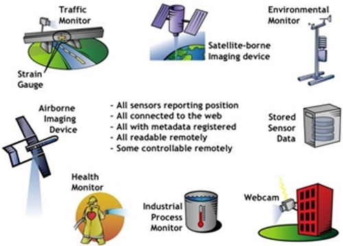
Figure 3: Increasing variety of sensors
(Source: www.opengeospatial.org)
The rate of capture or
velocity of data collection is directly related to the number of
sensors and their capability to collect data more frequently,
the ability to transmit data through wider data bandwidth, and
increased levels on connectivity through the internet. User
expectations and behaviour are also driving increased demand for
real-time data, particularly the social media platforms.
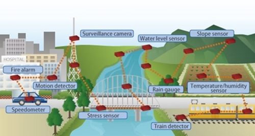
Figure 4: Increasing number and rate of
data capture from sensor networks
(Source: Fujitsu Intelligent Society Solution – Smart Grid
Communications)
The veracity or quality of geospatial data varies
dramatically. Many large geospatial data sets acquired
from sources such as satellite imagery generally have well known
data quality characteristics. However, there are many sources of
data where the quality is unknown or where the data provided on
quality may not be accurate. This continues to be a major
challenge in utilising the emerging data sources with
traditional or authoritative data sources. Research
continues on approaches and methods to validate the quality of
data to ensure it is “fit for purpose”.
Geospatial data is multi-dimensional and has traditionally
been presented as charts, tables, drawings, maps and imagery.
The ability to reorganise data using a geospatial framework
provides a powerful tool for decision makers to interpret
complex data quickly through visualisation tools such as 3D
models, animations and change detection.
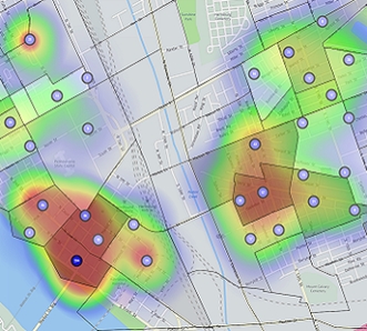
Figure 5: Pattern
analysis (Source: www.hexagongeospatial.com)
The improved inter-connectivity of sensors and the
repositories where the data is stored has now enabled data to be
readily integrated like never before. Personal and closed
repositories are now being replaced by cloud storage technology
which allows not only secure storage but also the ability to
make the data discoverable and visible to other users. Sharing
of data with specific individuals or everyone is now possible
and easily achieved.
5. Trends and Drivers in Big Geospatial Data Growth
Many of the current systems and institutional processes for
managing geospatial data were not designed for the current
dynamic and demanding information environment. The focus
for national and sub-national mapping agencies has been to
provide reliable and trusted data for their primary business or
to meet legislative requirements. These environments are
generally restrictive in their data sharing arrangements and
most data is held within institutional repositories within
government agencies, which often brings a high degree of
institutional inertia. Due to the time and costs to
implement new data models and strategies, these organisations
are also often slow to respond to new information management
approaches and conservative in their data sharing due to
government restrictions and legislation.
The development of spatial data infrastructures has followed
the approach of capturing the data once and then using the data
many times. The continual improvement in spatial data
infrastructures has relied on the fact that many of the
authoritative data sets will remain largely stable in their
format, structures and business needs. This has enabled
these data sets to be continually maintained and improved using
traditional approaches but may not encourage innovation or
change.
However, the big data approaches are now challenging this
paradigm (Figure 6). The continuous capture and re-capture
of data from multiple sensors has provided new opportunities and
approaches to be considered. Integrating and analysing
multiple data sets has allowed new data sets to be built and
customised for the users. Being able to share and re-share
this data through multiple platforms including social media has
created expectations that all data should be available in a
user-friendly and timely manner
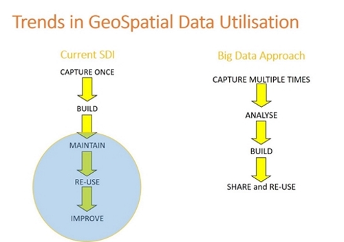
Figure 6: Changing trends in geospatial
data utilisation
The drivers for growth in geospatial data demand and
utilisation are due to a number reasons including:
- Advances in information technology and communication
- Smartphone technology
- New sensor technologies, and
- Mobile user applications and business opportunities
The improvement in the communication technologies and data
infrastructure has been a fundamental driver for increased
growth and utilisation. High quality broadband
infrastructure and high speed mobile phone and data technologies
has enabled developing, emerging and developed societies to
rapidly utilise the new mobile technologies. Smartphones
and tablets are now the technology of choice for accessing and
communicating data for the majority of users. Just as the growth
in laptop devices recently overtook the growth in desktop
computers, smartphone utilisation by adults in the UK has now
overtaken the utilisation of laptops (Figure 7). This trend
continues to support the preference for mobile technology, not
just with teenagers but also by adults. Smartphones and tablet
technologies now provide the benefit of mobility with the data
capabilities of many laptops and desktops through the mobile
applications and tools for both business and private usage.
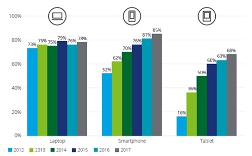
Figure 7: Smartphone, laptop and tablet
penetration among UK adults, 2012-17
(Source: Deloitte Mobile Consumer Survey, 2017)
The dramatic impact that has been made on society by the
mobile phone technology and data communication has been
supported by the development of mobile software applications.
These applications range from simple web search tools and
utilities, to complex business tools and social media. Social
media applications such as Twitter, Facebook and Instagram now
have billions of users and followers generating massive volumes
of data including text messages, images and videos. The
connectivity to other data sources via the internet has created
an incredible network of data linkages and forms the foundation
of the business model for these platforms to monetise their user
interactions.
6. Challenges and Opportunities to Link Big Data and
Authoritative Geospatial Data
An enormous amount of data is now created and utilised, not
only by commercial organisations and governments, but also by
the billions of individual users on ICT technologies. In recent
times, there has been an increased interest in the use of big
data and crowd-sourced data (CSD) for both research and
commercial applications. Volunteered Geographic Information
(VGI) (Goodchild 2007), with its geographic context, can be
considered a subset of Crowd-sourced Data (CSD) (Goodchild
& Glennon 2010; Heipke 2010; Howe 2006; Koswatte et al. 2016).
VGI production and use have also become simpler than ever before
with technological developments in mobile communication,
positioning technologies, smart phone applications and other
infrastructure developments which support easy to use mobile
applications.
However, data quality issues such as credibility, relevance,
reliability, data structures, incomplete location information,
missing metadata and validity continue to be one of big data’s
major challenges and can limit its usage and potential benefits
(De Longueville et al. 2010; Flanagin & Metzger 2008; Koswatte
et al. 2016). Research in extracting useful geospatial
information from large social media data sets to support
disaster management (de Albuquerque et al. 2015; Koswatte et al.
2015) and the update of authoritative sets from other
non-authoritative data such as Open Street Maps (Zhang et al.
2018) has identified the potential of data geospatial data
analytics.
Data analytics and machine learning are already widely
utilised in the analysis of large volumes of data collected by
the search engine and social media companies. Similarly,
opportunities exist within areas of big geospatial data where
improvements in the quality and currency of existing
authoritative data sets could be achieved. Although
authoritative geospatial data is generally of a very high
quality, errors in quality geospatial data sets are not
uncommon. For example, in the early data versions of
Google Maps, much of the data was originally acquired from
authoritative geospatial sources. However, the data was not
originally designed for navigational purposes and therefore some
roads that existed as roads in a database were not yet built and
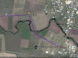
hence could not be used for navigation. As figure 8 (a)
illustrates, the 2009 version of Google Maps of an area in
Queensland, Australia, provided incorrect navigation data that
would have directed the driver through a farm and into a river.
However, nine years later, and with improved data provided
through geospatial data analytics, the correct navigational
route has been identified (figure 8b).
 |
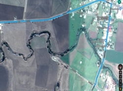 |
Figure 8: (a) 2009 incorrect directions Google Maps
directions with road passing through a river and (b) 2018
updated and correct directions based on driver information
One of the major challenges for mapping agencies is to
identify changes in their data themes when new development or
changes occur, for example if a new property is constructed or
changes to a building footprint is undertaken. In these
instances, it would be beneficial to periodically analyse high
resolution satellite imagery to identify these temporal changes
to alert the data editors that potential changes have occurred.
Geospatial data analytics of big data can facilitate this change
detection through temporal analysis of high resolution imagery
at regular intervals.
Artificial intelligence (AI) can encompass a range of
approaches that can lead to the automated analysis of large data
sets. Rules based approaches provide a framework for analysing
data based on defined requirements or rules. These approaches
may be suitable for analysing geospatial data held in regulatory
environments where certain conditions are required for
compliance. For example, minimum distance clearances or offsets
from the boundaries of a property may be required under planning
regulations. On the other hand, machine learning analyses data
to identify patterns, learns from these patterns and then can
self-improve once the system is trained. It is used widely in
analysing patterns of internet searching and social media which
can help predict the needs and preferences of users in order to
better customise searches and also market products. A hybrid
approach that draws on a combination of machine learning and
existing rule sets, such as geographic placename gazetteers, may
provide a suitable platform for improving geospatial databases.
Importantly, to integrate disparate data sets and models,
special domain terminology and language needs to be established
through the development of geospatial semantics and ontologies.
Finally, the improvements in the locational accuracy of
mobile sensors, particularly smartphones, will provide
opportunities to improve the quality of a range of geospatial
data sets. The recent release of a dual frequency GNSS chipset
for smartphones now provides the opportunity to capture improved
2D and 3D positional data. Potential applications may include
the collection of positional data for transport or
infrastructure that may improve the locational accuracy of low
spatial quality data sets. The improved 3D accuracy of the
spatial location of devices may provide better information to
support emergency services in cases of search and rescue.
7. Conclusions
We are now living in a highly data driven and data centric
society where the expectations of the data users are ever
increasing. The geospatial industry has continued to lead
in the development of innovative solutions that provide improved
outcomes for citizens and communities. The big data environment
presents a range of challenges for the custodians of
authoritative geospatial data sets and opportunities for
industries that are seeking to embrace the new big data
opportunities.
References
Bakri, A & Fairbairn, D 2011, 'User Generated Content and
Formal Data Sources for Integrating Geospatial Data', in
Proceedings of the 25th International Cartographic Conference:
proceedings of theProceedings of the 25th International
Cartographic Conference, A Ruas (ed.), Paris, France.
Bishr, M & Kuhn, W 2007, 'Geospatial information bottom-up: A
matter of trust and semantics', in S Fabrikant & M Wachowicz
(eds), The European information society: Leading the way with
geo-information, Springer, Berlin, pp. 365-87.
Budhathoki, NR & Nedovic-Budic, Z 2008, 'Reconceptualizing
the role of the user of spatial data infrastructure',
GeoJournal, vol. 72, no. 3-4, pp. 149-60.
de Albuquerque, JP, Herfort, B, Brenning, A & Zipf, A 2015,
'A geographic approach for combining social media and
authoritative data towards identifying useful information for
disaster management', International Journal of Geographical
Information Science, vol. 29, no. 4, pp. 667-89.
De Longueville, B, Ostlander, N & Keskitalo, C 2010,
'Addressing vagueness in Volunteered Geographic Information
(VGI)–A case study', International Journal of Spatial Data
Infrastructures Research, vol. 5, pp. 1725-0463.
Diaz, L, Remke, A, Kauppinien, T, Degbelo, A, Foerster, T,
Stasch, C, Rieke, M, Baranski, B, Broring, A & Wytzisk, A 2012,
'Future SDI – Impulses from Geoinformatics Research and IT
Trends', International Journal of Spatial Data Infrastructures
Research, vol. 07, pp. 378-410.
Elwood, S 2008, 'Volunteered geographic information: future
research directions motivated by critical, participatory, and
feminist GIS', GeoJournal, vol. 72, no. 3-4, pp. 173-83.
Evans, MR, Oliver, D, Zhou, X & Shekhar, S 2014, 'Spatial Big
Data: Case Studies on Volume, Velocity, and Variety', in HA
Karimi (ed.), Big Data: Techniques and Tecnologies in
Geoinformatics, CRC Press, pp. 149-76.
Flanagin, AJ & Metzger, MJ 2008, 'The credibility of
volunteered geographic information', GeoJournal, vol. 72, no.
3-4, pp. 137-48.
Goodchild, MF 2007, 'Citizens as sensors: the world of
volunteered geography', GeoJournal, vol. 69, no. 4, pp. 211-21.
Goodchild, MF & Glennon, JA 2010, 'Crowdsourcing geographic
information for disaster response: a research frontier',
International Journal of Digital Earth, vol. 3, no. 3, pp.
231-41.
Harris, TM & Lafone, HF 2012, 'Toward an informal Spatial
Data Infrastructure: Voluntary Geographic Information,
Neogeography, and the role of citizen sensors', in K Cerbova & O
Cerba (eds), SDI, Communities and Social Media, Czech Centre for
Science and Society, Prague, Czech Republic, pp. 8-21.
Hart, G & Dolbear, C 2013, Linked Data: A Geographic
Perspective, CRC Press, NW, USA.
Heipke, C 2010, 'Crowdsourcing geospatial data', ISPRS
Journal of Photogrammetry and Remote Sensing, vol. 65, no. 6,
pp. 550-7.
Howe, J 2006, 'The rise of crowdsourcing', Wired magazine,
vol. 14, no. 6, June 2006, pp. 1-4.
Jackson, M, Rahemtulla, H & Morley, J 2010, 'The synergistic
use of authenticated and crowd-sourced data for emergency
response', in Proceedings of the 2nd International Workshop on
Validation of Geo-Information Products for Crisis Management
(VAL-gEO): proceedings of theProceedings of the 2nd
International Workshop on Validation of Geo-Information Products
for Crisis Management (VAL-gEO) Ispra, Italy.
Koswatte, S, McDougall, K & Liu, X 2015, 'SDI and
crowdsourced spatial information management automation for
disaster management', Survey Review, vol. 47, no. 344, pp.
307-15.
Koswatte, S, McDougall, K & Liu, X 2016, 'Semantic Location
Extraction from Crowdsourced Data', ISPRS-International Archives
of the Photogrammetry, Remote Sensing and Spatial Information
Sciences, pp. 543-7.
Li, S, Dragicevic, S, Castro, F, Sester, M, Winter, S,
Coltekin, A, Pettit, C, Jiang, B, Haworth, J, Stein, A & Cheng,
T 2016, 'Geospatial big data handling theory and methods: A
review and research challenges', ISPRS Journal of Photogrammetry
and Remote Sensing, vol. 115, pp. 119-33.
McDougall, K 2006, 'A Local-State Government Spatial Data
Sharing Partnership Model to Facilitate SDI Development', The
University of Melbourne, Melbourne.
Spinsanti, L & Ostermann, F 2010, 'Validation and relevance
assessment of volunteered geographic information in the case of
forest fires', in Proceedings of Validation of geo-information
products for crisis management workshop (ValGeo 2010):
proceedings of theProceedings of Validation of geo-information
products for crisis management workshop (ValGeo 2010) JRC Ispra.
Zhang, X, Yin, W, Yang, M, Ai, T & Stoter, J 2018, 'Updating
authoritative spatial data from timely sources: A multiple
representation approach', International Journal of Applied Earth
Observation and Geoinformation, vol. 72, pp. 42-56.
Bibliographical notes

Professor Kevin McDougall is currently the Head of the School
of Civil Engineering and Surveying at the University of Southern
Queensland (USQ). He holds a Bachelor of Surveying (First
Class Honours) and Master of Surveying and Mapping Science from
the University of Queensland, and a PhD from the University of
Melbourne. Prior to his current position Kevin has held
appointments as Deputy Dean, Associate Dean (Academic) and the
Head of Department of Surveying and Spatial Science at USQ. He
has served on a range of industry bodies and positions including
the Queensland Board of Surveyors, President of the
Australasian Spatial Information Education and Research
Association (ASIERA) from 2002-2008 and the Board of Trustees
for the Queensland Surveying Education Foundation. Kevin
is a Fellow of Spatial Sciences Institute and a Member of The
Institution of Surveyors Australia.

Dr Saman Koswatte
obtained his PhD from the School of Civil Engineering
and Surveying, Faculty of Health Engineering and Science, University of
Southern Queensland, Australia. He is undertakes research in the fields
of Crowdsoursed geospatial data, Geospatial Semantics and Spatial Data
Infrastructures. He is holding MPhil degree in Remote Sensing and GIS
from University of Peradeniya, Sri Lanka and a BSc degrees in Surveying
Sciences from Sabaragamuwa University of Sri Lanka. He is a Senior
Lecturer in the Faculty of Geomatics, Sabaragmauwa University of Sri
Lanka and has over ten years of undergraduate teaching experience in the
field of Geomatics
Contacts
Professor Kevin McDougall
School of Civil Engineering and Surveying
University of Southern Queensland
West Street, Toowoomba Qld 4350, AUSTRALIA
Tel. +617 4631 2545
Email: mcdougak[at]usq.edu.au
Dr Saman Koswatte
Department of Remote Sensing and GIS
Faculty of Geomatics,
Sabaragamuwa University of Sri Lanka,
P.O. Box 02, Belihuloya, 70140, SRI LANKA
Tel. +944 5345 3019
Email: sam[at]geo.sab.ac.lk


