Bridging the Gap between Surveyors and the Geo-Spatial Society
by Hartmut Müller, Germany

Hartmut Müller
1)
The paper was presented in a joint FIG/ISPRS session at the ISPRS
Congress July 2016 in Prague. The author discusses the role of surveyors
today in a complex and technologic advanced world and the requirements
of the surveyor of tomorrow.
KEY WORDS: Geospatial Information, Information Technology,
Management, Surveyor, Geo-data Manager
ABSTRACT
For many years FIG, the International Association of Surveyors, has
been trying to bridge the gap between surveyors and the geospatial
society as a whole, with the geospatial industries in particular.
Traditionally the surveying profession contributed to the good of
society by creating and maintaining highly precise and accurate
geospatial data bases, based on an in-depth knowledge of spatial
reference frameworks. Furthermore in many countries surveyors may be
entitled to make decisions about land divisions and boundaries. By
managing information spatially surveyors today develop into the role of
geo-data managers, the longer the more. Job assignments in this context
include data entry management, data and process quality management,
design of formal and informal systems, information management,
consultancy, land management, all that in close cooperation with many
different stakeholders. Future tasks will include the integration of
geospatial information into e-government and e-commerce systems. The
list of professional tasks underpins the capabilities of surveyors to
contribute to a high quality geospatial data and information management.
In that way modern surveyors support the needs of a geo-spatial society.
The paper discusses several approaches to define the role of the
surveyor within the modern geospatial society.
1. INTRODUCTION
Surveying is a profession with a long history. Since ancient times
surveyors were involved in measuring and depicting the earth’s surface
with the natural, built and planned environments. Driven by the advances
of technologies including computing, communications and geospatial data
processing, the recent decades have shown increased demand and
importance on accurate, timely and user-friendly geospatial information
(Fosburgh, 2011, see also Seedat, 2014). As a result, the surveyor’s
role today includes communication with various stakeholders including
engineers, architects, planners, local government, landowners, utility
service providers and others. The surveyor’s new function has
transformed to that of geo-data manager, creating, verifying or
modifying digital data sources and design models of various kind.
Surveyors have to play an active part in GIS activities, such as
creating, filling and maintaining a GIS, and using it as a tool to
manage the natural and built environment as well as the cadastre. The
surveyor’s activities in GIS data collection are measurements, but also
collection and management of attributes about the elements they
geo-locate.
Most likely technology will play an even greater role in the future.
Field systems can be coupled with mobile phone and Internet access,
cloud computing and web-based geodatabases. In that way information and
techniques can be combined to an extent never before thought.
Traditionally, surveyors are well educated in terms of theory,
mathematics, principles of redundancy and quality assurance. The
opportunity for the surveyor to provide services that enable best
practices in data collection and quality assurance is still present
today. More than that, the deeper understanding of processes is even
more important in times where the surveying equipment has become so
user-friendly that the technology in most cases can be used by
non-surveyors. The ability to plan with a GIS and to use it to
understand ongoing processes is a huge opportunity for a geo-data
manager.
The surveyor of the future is able to extract new information and
knowledge from existing datasets and to provide it to land managers. The
society insists on speedier data collection and generation of useful
information. Therefore, it becomes imperative to use analysis tools for
managing, verifying and interpreting vast data volumes, data collection
for populating and updating the GIS, quality assurance and data
management and analysis. Communicating the information to the users will
be another key challenge. Surveyors should be prepared to present
information using a variety of media including static and dynamic
visualizations.
The surveyor of the future must demonstrate a broad set of
multidisciplinary skills. He or she must have the skills to navigate
various cultural and technical barriers as well as to communicate across
different knowledge areas, disciplines and customary local processes.
The world today has evolved from data collection into geo-data
management and information and knowledge extraction. Individual
surveyors, and the societies they belong to, must collaborate with
academia, government and industry to achieve common goals and benefits.
Fosburgh, 2011 states that surveyors are the geo-data managers of the
future--and that tomorrow’s professionals are prepared for the challenge
through education, training and professional development. In the
following sections the positions of FIG, the International Federation of
Surveyors and of DVW, German Society of Geodesy, Geoinformation and Land
Management in this debate will be reported.
2. FIG DEFINITION OF THE FUNCTIONS OF THE SURVEYOR
FIG is a federation of national associations and represents the
surveying disciplines. Its aim is to ensure that the disciplines of
surveying and all who practise them meet the needs of the markets and
communities that they serve. It realises its aim to ensure that the
disciplines of surveying meet the needs of markets and communities by
promoting the practice of the profession and encouraging the development
of professional standards. In 2004, the FIG General Assembly adopted its
own definition of the functions of the surveyor (FIG, 2004).
2.1 The official FIG definition
2.1.1 Executive summary: A surveyor is a
professional person with the academic qualifications and technical
expertise to conduct one, or more, of the following activities;
- to determine, measure and represent land, three-dimensional objects,
point-fields and trajectories;
- to assemble and interpret land and geographically related information,
- to use that information for the planning and efficient administration
of the land, the sea and any structures thereon; and,
- to conduct research into the above practices and to develop them.
2.1.2 Detailed
functions: The surveyor’s professional tasks may involve one or more of
the following activities which may occur either on, above or below the
surface of the land or the sea and may be carried out in association
with other professionals.
- The determination of the size and shape of the earth and the
measurement of all data needed to define the size, position, shape and
contour of any part of the earth and monitoring any change therein.
- The positioning of objects in space and time as well as the
positioning and monitoring of physical features, structures and
engineering works on, above or below the surface of the earth.
- The development, testing and calibration of sensors, instruments and
systems for the above-mentioned purposes and for other surveying
purposes.
- The acquisition and use of spatial information from close range,
aerial and satellite imagery and the automation of these processes.
- The determination of the position of the boundaries of public or
private land, including national and international boundaries, and the
registration of those lands with the appropriate authorities.
- The design, establishment and administration of geographic
information systems (GIS) and the collection, storage, analysis,
management, display and dissemination of data.
- The analysis, interpretation and integration of spatial objects and
phenomena in GIS, including the visualisation and communication of such
data in maps, models and mobile digital devices.
- The study of the natural and social environment, the measurement of
land and marine resources and the use of such data in the planning of
development in urban, rural and regional areas.
- The planning, development and redevelopment of property, whether
urban or rural and whether land or buildings.
- The assessment of value and the management of property, whether
urban or rural and whether land or buildings.
- The planning, measurement and management of construction works,
including the estimation of costs.
In the application of the foregoing activities surveyors take into
account the relevant legal, economic, environmental and social aspects
affecting each project.
2.2 Recent developments in FIG
The definition reported in Section 2.1 reflects to a great extent the
traditional professional field of surveyors. At the FIG Working Week in
Rome, Italy, (May 6-10, 2012) FIG started to broaden its view towards a
wider definition, described by the term ‘Surveyor 2.0’ (Schennach et
al., 2012). Teo CheeHai, past president of FIG, has noticed that ‘the
role of the surveyor is evolving from a professional who used to be
viewed as a “measurer” to a professional who measures, models, and
manages’.
ACSM, 2012 notes rapid technological changes are taking place in a
challenging economic and political landscape. Online and mobile
services, such as online maps and smartphone apps, are stimulating an
increasing interest and use of geospatial information. Citizen-centric
service delivery is crucial. In this interview the president argues,
that surveyors ‘will be required to embrace open standards; be
inclusive, learn to incorporate volunteered information; ensure
interoperability of systems, institutions and legislation; have a
culture of collaboration and sharing to avoid duplication; develop
enabling platforms in order to deliver knowledge derived from data of
different scales and origins in the form of “actionable” information’.
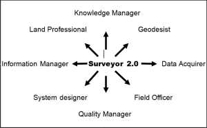
In an ongoing discussion FIG now promotes the ‘Surveyor 2.0 model’ (Fig.
1).
 |
 |
Figure 1. The Surveyor 2.0 Model,
adapted from G. Schennach et al. (2012)
Here, the surveyor is described in the triad Manage-Model-Measure. Such
a definition seems to largely overlap with the definition of a geo-data
manager (see the following section).
3. THE PROFILE OF A GEO-DATA MANAGER
Recently, in an ongoing process the Working Group ‘Geoinformation and
Geo-data Management’ of the German DVW, Society for Geodesy,
Geoinformation and Land Management worked on the definition of a
geo-data manager’s functions. In the following sections some
intermediate results of the work will be reported.
3.1 The framework of geo-data management
Geo-data management is a cross-cutting task of Geodesy and
Geoinformatics comprising three core areas of expertise (Fig. 2):
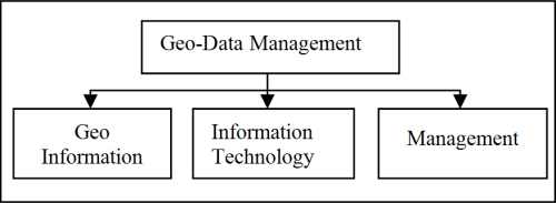
Figure 2. The triad of Geo-data Management,
(German DVW Working Group, 2016, unpublished)
1. Geoinformation; in particular application-specific recording, quality
assurance, analysis and presentation of spatial objects based on the
geodetic spatial reference of position, height and gravity (Geo skills),
2. Information technology; in particular technology of data and systems,
design and implementation of technical solutions, development of
service-oriented architectures and systems, modeling, coding and
automation of data exploration, by methods of information and
communication technology (IT skills)
3. Management; in particular strategic development, structuring,
coordination and control of processes, by communication with all
involved parties (management skills)
3.2 The individual profile of a geo-data manager
Depending on the individual field of work a geo-data manager may face a
considerable range of required skills in the three core areas of
expertise Geoinformation, Information technology, Management. The full
requirements profile of a geo-data manager comprises the following
components
3.2.1 Professional
skills: the following section describes the full list of currently
identified professional skills of a geo-data Manager.
- Establishment of a framework for the comprehensive use of geospatial
data. The geo-data manager coordinates development and operation of
spatial data infrastructures to provide spatial data from different
sources by interoperable spatial data services. He or she moderates the
interests of providers and users and develops the legal, professional,
technical and organizational framework for the comprehensive use of
spatial data. He or she develops application-driven specifications for
data provision via standard based services. He or she monitors
compliance with the specifications to ensure the multidisciplinary
usability of spatial data (interoperability).
- Identification of spatial data needs, as-is analysis and data
collection. The geo-data Manager identifies and analyzes the user
requirements (internal vs. external users) in the context of specific
applications. He or she gets an overview of available data (inventory
analysis of in-house offers against third party offers) and evaluates
the potential benefit of spatial data sets for specific application
areas, in cooperation with experts from other disciplines. He or she
procures appropriate spatial data obtained by third parties and
clarifies access, usage and pricing conditions.
- Data processing, administration, management and updating. The geo-data
Manager collects existing data, transforms them into consistent data
formats, integrates them geometrically and semantically into a
Geographic Information System (GIS), prepares them to meet individual
professional requirements, updates and maintains them. He or she
accomplishes these tasks within an established framework and provides
the necessary transformation rules, exchange formats and meta data.
- Application-specific exploration of spatial data, process integration
and information management. By analyzing and redesigning processes and
by developing an adapted role model the geo-data manager supports the
integration of data products into an existing environment of
administrative and business processes. To generate new information he or
she designs and implements automated analysis of combinations of spatial
data from different sources (exploration of Big Geo-Data). He or she
prepares the results clearly. He or she is involved in collaboration
processes with other disciplines to interpret spatial data
appropriately. He or she ensures that the necessary information is
generated in a user-centric form.
- Design of new data products. On the basis of needs assessment and
inventory analysis the geo-data manager designs new data products for
specific applications while also taking into account future demands of
stakeholders. To achieve that, he or she creates conceptual application
schemes in communication with other specialists and IT experts data.
Following his or her professional expertise the coding for the data
transfer in appropriate data formats will be performed (external
schema). He or she provides support for the implementation of the data
management policy
- Development of production methods. The geo-data manager identifies
appropriate methods for the geodetic collection of the product data
(initial recording vs. updating, such as terrestrial surveying, remote
sensing, crowdsourcing, mobile mapping) and adapts them to the technical
requirements. He or she coordinates the interaction of different
partners to create novel data products. He or she develops quality
assurance procedures to guarantee for the long-term professional and
technical product quality which meets the user requirements.
- Definition of the general data production environment, particularly
for marketing and sales activities. The geo-data manager determines the
framework for spatial data marketing and sales. He or she determines
product names and product specifications, takes into consideration any
access restrictions (copyright, security, privacy) and other obligations
determined by legal regulations. He or she defines the usage and payment
terms, targeted markets, distribution channels, product availability,
performance and provided capacity of the data production process. He or
she creates the documentation of product specification, for in house use
and for publication in metadata catalogs provided within spatial data
infrastructures.
- Implementation and operation of an IT infrastructure to manage spatial
data (GeoIT infrastructure). The geo-data manager identifies data
volumes, access rights, facades and role models for the use of spatial
data in an organization. Following the trends of the mainstream IT he or
she designs a standards based architecture of an appropriate GeoIT
infrastructure. The design of such architecture includes the system
design of network, servers, database management system, application
technology, referring to modern IT concepts (SOA, ROA, etc.) including
operation and safety concepts (ITSM). He or she makes decisions on the
necessary components of the GeoIT infrastructure, such as GIS, software
/ hardware and other technical core components (geo portals, geo
catalogues, etc.).
- Design and development of services and applications. Following the
identified and adopted user requirements the geo-data manager develops
spatial data processing services to facilitate the implementation of
user-specific applications (desktop, web, mobile) such as specialized
geographic information systems vs. mainstream e-government applications
and other procedures.
- Quality management and quality control. The geo-data manager designs
and implements the user oriented framework for quality assurance of the
spatial data and of the derived products. He installs mechanisms to
monitor the entire process chain in order to ensure the spatial data
product quality.
- Basic, advanced and further training.
The geo-data manager provides basic, advanced and further user training.
3.2.2 Methodological and social skills: the
following section describes the most important identified methodological
and social skills of a geo-data Manager
1 Project management. The geo-data manager is involved in award
procedures, support, monitoring, controlling, resource management
(human, technical, financial), process documentation, reporting,
profitability analysis, decision management, and operational management
of spatial data projects and products.
2 Coordination. The geo-data manager coordinates and controls all
spatial data related processes in cooperation with all stakeholders. He
or she is the link between the technical and administrative management
levels. He or she moderates and supports the cooperation of different
stakeholders and ensures transparency in the project consortium
(information sharing).
3 Moderation. The geo-data manager moderates complex processes in a
highly interdisciplinary context. Fast-moving developments in the
digital world continuously generate processes of change. Different
understanding of the same topics across different professional
disciplines has to be considered. Reservations with regard to Geo-IT
infrastructures are still present. In this environment the geo-data
manager has to be a conflict manager who has pronounced negotiation
skills.
4. CONCLUSIONS
In the previous sections it was shown in which ways today’s surveyors
can take action for the benefit of a modern geospatial society. Job
assignments in this context include technical tasks such as data entry
management of highly heterogeneous spatial data created by classical
surveying activities, mobile mapping, aerial and satellite imagery,
crowdsourcing activities, and others; information management, consisting
of data integration and transformation, of data integration from
different sources, general IT, web technologies; quality management,
including responsibility for the accuracy of attributes and
relationships of data, for accuracy assessment, for completeness and
reliability of data, for certification; system design of formal and
informal systems for security of land tenure, for creation and
maintenance of code lists, for spatial data infrastructures, for 2D and
3D data management, workflows, business processes. In such a highly
interdisciplinary working environment non-technical skills are required
for interpersonal communication, including responsibility for
participation management, handling of appeal procedures, and conflict
resolution. Consultancy for urban and rural development, reorganization,
real estate issues, spatial planning may be further components of the
professional work. Future tasks include the integration of geospatial
information into e-government and e-commerce systems. Surveyors have the
potential to perform high quality geospatial data and information
management. If the surveying profession takes the plunge into the new
fields the gap between surveyors and the geospatial society can be
closed.
Acknowledgements
Decisive contributions of the members of the German Working Group André
Caffier, Dieter Heß, Martin Scheu, Markus Seifert, Robert Seuß to this
work are well acknowledged.
References
- Schennach, G., Lemmen, C., Villikka, M., 2012.
Be part of the solution,
not the problem! FIG Working Week, Rome, Italy. GIM International, July
2012, pp 33-35.
(10 May 2016).
- FIG, 2004.
FIG Definition of the functions of the surveyor
(10 May
2016).
- ACSM, 2012. FIG looks to surveyor 2.0, ACSM Bulletin June 2012, pp
31-32. 10 May
2016).
- Sass, J., 2012.
The surveyor’s role as geo-data manager, Machine Control
Magazine, Vol. 2 No. 3, 2012, Spatial Media, pp 45-47, (10 May 2016).
- Seedat, M., 2014.
The surveyor’s role as geo-data manager,
(10 May 2016)
- Fosburgh, B., 2011.
The evolution of the geo-data Manager,
(10 May 2016).
Contact
Hartmut Müller
Mainz University of Applied Sciences,
Institute for Spatial Information and Surveying Technology (i3mainz),
Lucy-Hillebrand-Str. 2,
D-55128 Mainz, Germany
hartmut.mueller@hs-mainz.de
|


